Friday, June 26, 2015

Nigeria signs deal for Synthetic-Aperture Satellite with UK firm

Synthetic-Aperture Satellite: FG signs N49.7 trillion deal with UK firm
FG, UK firm sign $250m satellite deal
Selected Interpretation Results: NIGERIA
Reports reveal that the Federal Government on Friday in Abuja signed a $250 million joint venture/partnership agreement with a United Kingdom-based company, Menasat Gulf Group Plc., to provide Synthetic-Aperture Radar satellites in the country.
Sources say when operational, the SAR satellite technology will be the first in Nigeria, while images generated from it will benefit, particularly, the oil and gas operators, farmers, ocean monitoring, tracking of oil pipelines and also assist the military.
According to Punch.ng the Director-General of the National Space Research and Development Agency, Dr. Seidu Mohammed, while signing the contract, said the SAR technology was necessary for Nigeria because of the challenges the agency have had in acquiring images in, mostly, the southern part of the country.
“We have always had this constraint that even though we are the national  repository for satellite images, we are not able to provide completely all the required images in this country. In the light of that, we have specially taken this opportunity to satisfy the Nigerian market,” he said.

Related/Background

NASA FAA GA-ASI and Honeywell commence Third UAS sense-and-avoid tests

UAS Magazine – The Latest News on Unmanned Aerial Systems - NASA commences UAS sense-and-avoid tests
From mid-June through July, the agency’s project on UAS Integration in the National Airspace System (NAS) will conduct flight testing of sense-and-avoid technology at the NASA Armstrong Fight Research Center in California. These flights will conduct the first full test of an automatic collision avoidance capability on autonomous aircraft. Participating in the tests are the U.S. Federal Aviation Administration (FAA), General Atomics Aeronautical Systems Inc. and Honeywell International Inc.
 ::::
The sense-and-avoid flight tests at Armstrong are the third in a series of tests building on similar experiments conducted late last year to demonstrate a proof-of-concept sense-and-avoid system. The tests engage the core air traffic infrastructure and supporting software components through a live and virtual environment to demonstrate how an autonomous aircraft interacts with air traffic controllers and other air traffic.

Ikhana aircraft, based at Armstrong, equipped
with an updated sense-and-avoid system
NASA, Partners Test Unmanned Aircraft Systems -- WASHINGTON, June 23, 2015 /PRNewswire-USNewswire/ --
This series of tests is made up of two phases. The first is focused on validation of sensor, trajectory and other simulation models using live data. Some of the tests will be flown with an Ikhana aircraft, based at Armstrong, that has been equipped with an updated sense-and-avoid system. The system includes a new traffic collision avoidance program and other advanced software from Honeywell.
Other tests will involve an S-3B plane from NASA's Glenn Research Center in Cleveland, serving as a high-speed piloted surrogate aircraft. Both tests will use other aircraft following scripted flight paths to intrude on the flight path the autonomous craft is flying, prompting it to either issue an alert or maneuver out of the other aircraft's path. These flights will also conduct the first full test of an automatic collision avoidance capability on autonomous aircraft.
During the June 17 test, which lasted a little more than five hours, the team accomplished 14 encounters using the Ikhana aircraft and a Honeywell-owned Beech C90 King Air acting as the intruder. A second test was flown the following day, with a total of 23 encounters. The project team plans to fly more than 200 encounters throughout the first phase of the test series.
"Our researchers and project engineers will be gathering a substantial amount of data to validate their pilot maneuver guidance and alerting logic that has previously been evaluated in simulations," said Heather Maliska, Armstrong's UAS-NAS deputy project manager.
The second phase of the third test series will begin in August and will include a T-34 plane equipped with a proof-of concept control and non-payload communications system. It will evaluate how well the systems work together so that the aircraft pilots itself, interacts with air traffic controllers and remains well clear of other aircraft while executing its operational mission. The aircraft, which will have an onboard safety pilot, will fly an operationally representative mission in a virtual airspace sector complete with air traffic control and live and virtual traffic.
For more information about NASA's aeronautics research, visit:
For more information on the UAS-NAS project, visit:


Previously/Background:

When Smart Bombs loose their magic it's back to WWII

We Can’t Always Count On Smart Bombs: CSBA « Breaking Defense
The U.S. military has enjoyed an enormous advantage in precision strike over the past 25 years. The success of America’s precision strike operations has not gone unnoticed, however. Potential enemies have invested in active and passive defenses that could force the U.S. military to fly more strike sorties and expend larger numbers of precision-guided munitions (PGMs) in future wars. In Sustaining America’s Precision Strike AdvantageMark Gunzinger and Bryan Clark assess the implications of a “salvo competition” between two adversaries that are both equipped with PGMs and capabilities to defend against precision strikes. The report concludes that attempting to compensate for an enemy’s defenses by using much larger numbers of the kinds of PGMs DoD has procured over the last 14 years may be infeasible. Instead of a “simply more” approach, the authors propose the Defense Department adopt operational concepts and field a new generation of offensive PGMs that will maintain its precision strike advantage in future salvo competitions.

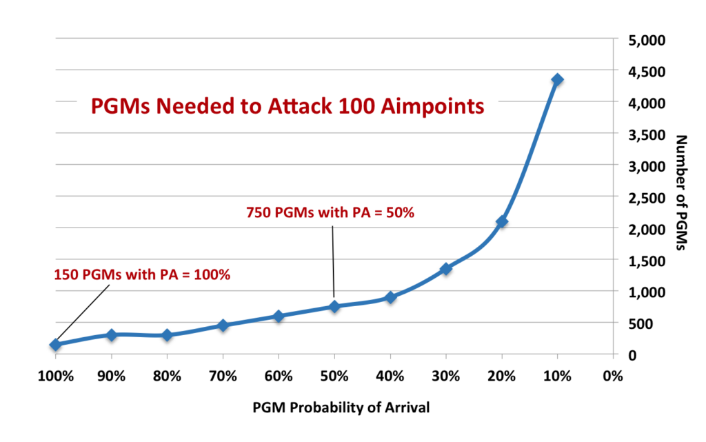
[Sustaining America’s Precision Strike Advantage | CSBA] a new study from the influential Center for Strategic and Budgetary Assessments says Countermeasures are growing more sophisticated and more common. Advanced anti-aircraft missiles can snipe a single smart bomb out of the sky, let alone the US aircraft carrying it. Jammers can scramble radar and GPS. Lasers and high-powered microwaves are becoming practical weapons against incoming missiles. So the smart bomb won’t always get through. Worse, as the odds of any single weapon hitting go down, the number of weapons required to assure a hit goes up exponentially, say CSBA authors Mark Gunzinger and Bryan Clark

Guided munitions try to counteract countermeasures
Guided munitions are not as sure as they used to be, given the increasing effectiveness of jammers and spoofing equipment that interfere with global positioning systems.
To counteract the defenses, the military and its industry partners use techniques such as redundant targeting systems like seekers that target GPS jammers, laser-guidance systems or camera-aided navigation, according to a report in Defense News.
Jammers can interfere with weak GPS signals and causes a guided weapon to lose its satellite connection, which could lead to a complete miss or a hit on an undesired target.

Foreign Military Studies Office Publications - Desert Defense and Surviving PGMs: the New Russian View


For a static defense the unresolved problem is how to move on a PGM-dominated battlefield, particularly in the desert, and survive. The Iraqis had no solution during the Gulf War. The Russians have published some tentative articles about mounting various ageometric-shaped screens above vehicles and moving behind minature robot vehicles which mimic the shape and signature of primary weapon systems, but there seems to be no present, effective solution. Currently, the only realistic solution appears to be to ride out the initial period of the war. Future conventional war, in the Russian view, would be fought in two phases. The first is the defensive, counter-PGM phase, during which border troops, air forces, defensive forces dug in and concealed in key points, limited-scale forces optimized for nonlinear combat, Spetsnaz, and forces equipped with high-technology weapon systems would attempt to gain the advantage. Meeting battles and meeting engagements, combat for point defenses and tactical-scale counterattacks would be the main forms of ground combat. Each side would target the other's PGMs and supporting systems to destroy enemy combat power, defeat/suppress enemy troop control and force him to deplete his PGM munitions. Once the PGM stocks were depleted to the point where they lacked operational impact, phase two (counteroffensive) would be launched and the war would develop along conventional lines.9
Clearly, the PGM threat cannot be disregarded when facing a foe with modern weaponry. PGM weaponry is most effective in the desert, but even in this open country, effective, inexpensive countermeasures can be devised. The Russian Army is just one of many armies looking for such countermeasures. 


Related/Background:


EA-6B to Prowl no more


Navy to Retire EA-6B Prowler at Week’s End
ARLINGTON, Va. – The Navy will formally retire the Northrop Grumman EA-6B Prowler electronic attack aircraft on June 27 following a three-day commemoration of the long-serving aircraft.
EA-6B veterans are expected to gather at Naval Air Station Whidbey Island, Wash., for a commemoration of the Prowler’s history and anecdotes from some of the pilots and electronic countermeasures officers who provided electronic attack for the U.S. Navy from aircraft carriers and for joint forces in the aircraft’s expeditionary role. 

Navy's EA-6B Prowler Takes Last Active Duty Flight Before Sunset Ceremony - USNI News
The Navy’s EA-6B Prowler electronic warfare jet flew its last active duty flight on Wednesday and officially decommissioned at the Museum of Flight in Seattle.
The Navy will host a formal sunset ceremony at Naval Air Station Whidbey Island on June 27, where the final jets from Electronic Attack Squadron VAQ-134 will fly away from their home station for the last time.
- See more at: http://news.usni.org/2015/05/28/navys-ea-6b-prowler-takes-last-active-duty-flight-before-sunset-ceremony#sthash.YCh36bQI.dpuf
The Navy’s EA-6B Prowler electronic warfare jet flew its last active duty flight on Wednesday and officially decommissioned at the Museum of Flight in Seattle.

The Navy will host a formal sunset ceremony at Naval Air Station Whidbey Island on June 27, where the final jets from Electronic Attack Squadron VAQ-134 will fly away from their home station for the last time.

The End Of An Era: The Transition From The Prowler To The Growler - AirlineReporter.com

Guards have UAVs with Morning Coffee

Guard practices CAS with UAV and A-10 in New Jersey


New Jersey National Guard soldiers and airmen teamed up with Marine Corps reservists and air support from the Maryland Air National Guard for key leader engagement and close air support exercises at Warren Grove Gunnery Range, N.J., June 16-18, 2015.


Department of Defense Photo Essay

Guardsmen Conduct Unmanned Aerial Vehicle Training
New Jersey National Guard Soldiers from Detachment 1, 104th Brigade Engineer Battalion stand by before launching a RQ-7 Shadow unmanned aerial vehicle during day two of Operation Morning Coffee, a joint exercise with the New Jersey Army and Air National Guard, Maryland Air National Guard, and the Marine Corps Reserve on Warren Grove Gunnery Range, N.J. on June 17, 2015. (U.S. Air National Guard photo by Tech. Sgt. Matt Hecht/Released)

VIRIN: 150617-Z-NI803-011
http://www.defense.gov/dodcmsshare/photoessay/2015-06/hires_150617-Z-NI803-011A.jpg
2138
======================
VIRIN: 150617-Z-NI803-004
http://www.defense.gov/dodcmsshare/photoessay/2015-06/hires_150617-Z-NI803-004A.jpg
2065
======================
VIRIN: 150617-Z-NI803-025
http://www.defense.gov/dodcmsshare/photoessay/2015-06/hires_150617-Z-NI803-025A.jpg
2138
======================
VIRIN: 150617-Z-NI803-072
http://www.defense.gov/dodcmsshare/photoessay/2015-06/hires_150617-Z-NI803-072A.jpg
======================

A New Jersey National Guard Soldier from the 50th Infantry Brigade Combat Team launches a RQ-11 Raven unmanned aerial vehicle during day two of Operation Morning Coffee, a joint exercise with the New Jersey Army and Air National Guard, Maryland Air National Guard, and the Marine Corps Reserve on Warren Grove Gunnery Range, N.J. on June 17, 2015. (U.S. Air National Guard photo by Tech. Sgt. Matt Hecht/Released)

VIRIN: 150617-Z-NI803-165

Thursday, June 25, 2015

ExactEarth going public to fund expansion

ExactEarth going public to fund expansion
ExactEarth, which is owned by Com Dev (73 per cent) and Spanish company Hisdesat Servicios Estrategicos S.A. (27 per cent), tracks maritime ships using satellites and high frequency radio signals.
It recently announced an agreement with Florida-based Harris Corp. that will see ExactEarth's ship tracking technology go into payloads built by Harris for a constellation of 58 new satellites called Iridium Next.
"Broadly speaking the opportunities we are looking to develop, certainly what we've done with the Harris agreement, set the stage for that," Mabson said of the plans to go public.
"We put a growth plan in front of our shareholders because we see additional opportunities for the business and that growth plan required extra funding and capital in order to achieve it," he said. 
 ::::
ExactEarth was started by Com Dev six years ago. The company, which currently employs 60 people, has developed nine separate and distinct products serving about 250 customers, says the prospectus.
It recorded a net loss of $1.8 million on revenue of $11.4 million in the six months ended May 1, according to the prospectus. It lost $1.4 million on revenue of $7.7 million in the same period a year earlier.
The global market for maritime information was worth $880 million US last year and is expected to grow to $2.1 billion US by 2024, ExactEarth says in the prospectus. The company operates mainly in the automatic identification system sector of that market, which was worth $42.7 million US last year and is expected to grow to $163 million US by 2024.
In the prospectus, ExactEarth says it will continue to expand its service offering and it is looking to serve customers outside of the maritime market.


New revolutionary satellite AIS Constellation provides global real time ship tracking | Government Security News
Cambridge, Ontario, June 8 – Together with Harris Corporation, exactEarth unveiled their second generation Satellite AIS (S-AIS) constellation, exactView™ RT powered by Harris. This advanced maritime tracking capability will see AIS payloads being deployed on 58 satellites as part of the Iridium NEXT constellation, leveraging exactEarth’s patented, proven advanced AIS message processing capability alongside Harris’ leading programmable payload architecture. Additionally, this new capability will utilize the inter-satellite communications capabilities of the Iridium NEXT constellation to deliver vessel AIS positions in real time. As a result exactView RT will provide continuous global coverage and the most persistent and optimized Satellite AIS solution for global AIS maritime awareness.

exactView RT powered by Harris offers:
  • Global average revisit of less than 1 minute
  • Customer data latency of less than 1 minute
  • The highest detection performance for both Class A and Class B AIS messages
  • Tracking of large populations of small vessels with ABSEA™ equipped AIS transceivers
  • Support for the future evolution of AIS to support VDES and other initiatives in the maritime VHF band
For the full press release, click here.

Related/Background:

Wednesday, June 24, 2015

O3b Networks connects in U.S. Navy 7th Fleet Trident Warrior 2015 Exercises

O3b Networks Successfully Participates in U.S. Navy 7th Fleet Trident Warrior 2015 Exercises - Press Release - Digital Journal

ST. HELIER, Jersey--(Business Wire)--O3b Networks today announced the successful testing of its Medium Earth Orbit (MEO) satellite connectivity with the U.S. Navy’s 7th Fleet during a Limited Objective Experiment (LOE) during Trident Warrior 2015. Together with lead integrator Oceus Networks and partner TrustComm, Inc., O3b demonstrated, and the Navy officially evaluated, the advantages the O3b satellite constellation provides.


O3bMaritime - Connectivity at Sea - O3b Networks
GD Satcom Technologies O3B 2.4m Ka-Band Terminal Antenna Systems
O3b’s MEO satellites are in a unique orbit significantly closer to earth than Geostationary (GEO) satellites, vastly reducing network latency. The high throughput O3b satellites also offer much greater capacity, supporting up to 1.6 Gbps in a single 700km/450NM wide beam, enabling true broadband speeds even at sea.

Read more: http://www.digitaljournal.com/pr/2591070#ixzz3dq49uNUe

O3b Networks Successfully Participates in U.S. Navy 7th Fleet Trident Warrior 2015 Exercises | Business Wire
O3b Networks Successfully Participates in U.S. Navy 7th Fleet Trident Warrior 2015 Exercises - MarketWatch

The “Trident Warrior” experiments are designed to identify new and innovative technologies, which will enable more effective naval operational capabilities. A primary goal is to realize Network Centric Warfare capabilities; achieving a military advantage based on providing more usable information directly to operations in theater. This is enabled through robust technology amongst dispersed units, coupled with seamless communications that allow those forces to interact and share information as soon as it becomes available in an asymmetrical warfighting environment.
O3b is a unique enabler of Network Centric Warfare capabilities, which was demonstrated during “Trident Warrior.” For the exercises, O3b 1.2m maritime tracking antennas were placed on the USS Fort Worth Littoral Combat Ship (LCS-3), which achieved connectivity speeds of approximately 600Mbps (200Mbps uplink, 400Mbps downlink).
O3b, Oceus, and TrustComm were able to prove they could provide much higher broadband connectivity than Navy vessels currently receive, to a ship while in theater. This enables applications and technologies never available to the U.S. Navy including 4G/LTE, WiFi, HD video streaming and telemedicine—all of which were accomplished during “Trident Warrior.”


To watch a video tour of the USS Fort Worth (LCS-3) streamed live during “Trident Warrior” via the O3b satellite service, please visit: https://www.youtube.com/watch?v=svlf9_BM1fg
“O3b Networks is delighted to be allowed to participate in Commander, 7th Fleet’s Trident Warrior 2015 exercises,” said “D” D’Ambrosio, EVP Government Solutions for O3b Networks. “We’ve been actively testing O3b with the Navy at SPAWAR’s SSC PACIFIC Common Optical Distribution Architecture (CODA) lab, where 7th Fleet first saw the service, but it’s great to see it deployed on a naval vessel and perform as advertised at sea.”
“Providing Maritime LTE services has been a major focus for Oceus Networks, and our partnership with O3b combines two robust technologies,” said Randy Fuerst, President and CEO of Oceus Networks. “The U.S. Navy, through Trident Warrior, was able to see first-hand how to achieve a high data rate with low latency and at an affordable cost in an operational environment.”
“TrustComm prides itself on delivering the most innovative, state-of-the-art capabilities to our customers,” said Bob Roe, CEO of TrustComm, Inc. “During Trident Warrior, the O3b service performed impressively, facilitating multiple bandwidth hungry operations simultaneously and exceeding expectations."

Previously/Background:


Tuesday, June 23, 2015

Radar Monitors Blast Furnace


A Measuring System for Burden Surface Temperature Field of Blast Furnace
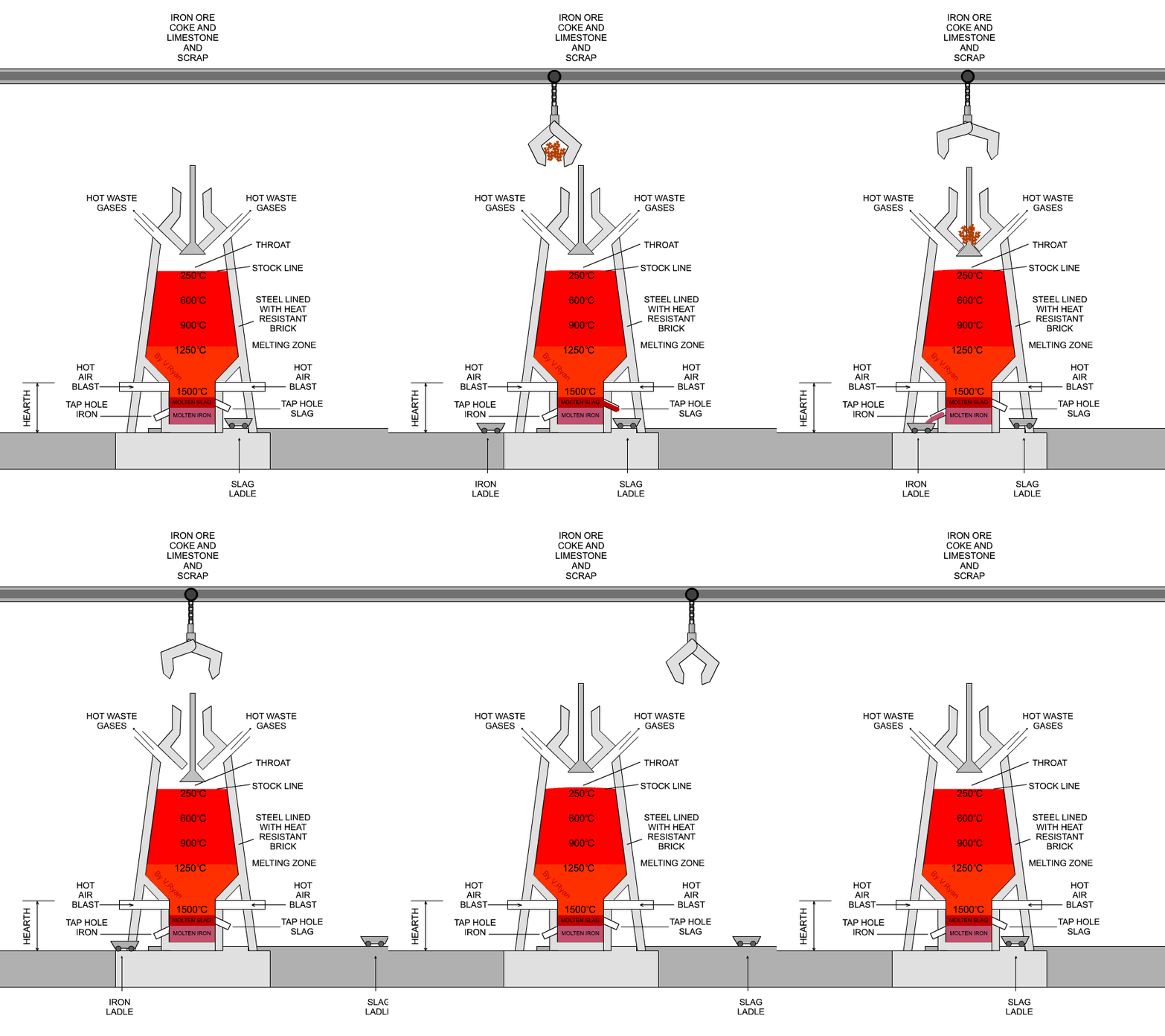
It is important to measure the burden surface temperature of blast furnace (BF) since it can be used to reflect the gas flow distribution and give instruction for BF operation.

Industrial high-temperature radar and imaging technology in blast furnace burden distribution monitoring process
Abstract -A new kind of industrial high temperature radar has been developed, which is used for real-time monitoring of the burden surface under the harsh environment inside blast furnace (BF) and observing the decline rate of the burden surface. This radar technology is also used for determination of the burden profile through multi-point arrangement of the radars. The 26GHz frequency radar is introduced with the FMSW structure of the hardware model, as well as the heat and dust resistant solid burden surface algorithm with the monitoring range of 0-100 meter and the measurement accuracy of 1%, a specially designed ceramic antenna with the temperature range of 0-600 degree, and the drift< 0.1%/year. Six industrial high temperature radars have been installed on the top of the BF at the industrial field, and optimized the radar installation location through electromagnetic simulation. The real-time image of the burden surface has been obtained by surface fitting and digital simulation of the data from the six-point radars. The effective application of this technology has improved significantly the fluctuation of burden surface, the production of BF, the energy saving and gas emission reduction.
  
3-Dimension Imaging System of Burden Surface with 6-radars Array in a Blast Furnace
Article in ISIJ International 52(11):2048-2054 · December 2011
Abstract - Harsh environment in Blast Furnace (BF) poses a big challenge for metallurgical industrial radar measurement of burden surface for ore and coke. The improved signal processing algorithm enhances the real-time performance. Antenna is specially designed for continuous stable signal acquirement, high temperature resistance and anti-dust ability. The experiment results illustrate that the single radar meets the accuracy requirement of solid bulk material. A new BF Burden Surface Measuring System is developed for real-time BE 3-D imaging. Distributed 6-radars array mounted on the top of 2 500 m(3) BF. A virtual 3-D imaging is achieved with a reconstruction algorithm of 6-radars array according to the actual shape of BF. 3-D imaging system with 6-radars array provides an improved technique for intelligent control of burden distribution during BE iron making process.

BLASTDAR- A Large Radar Sensor Array System for Blast Furnace Burden Surface Imaging
Zankl, D.; Schuster, S.; Feger, R.; Stelzer, A.; Scheiblhofer, S.; Schmid, C.; Ossberger, G.; Stegfellner, L.; Lengauer, G.; Feilmayr, C.; Lackner, B.; Burgler, T., "BLASTDAR – A Large Radar Sensor Array System for Blast Furnace Burden Surface Imaging," Sensors Journal, IEEE , vol.PP, no.99, pp.1,1
doi: 10.1109/JSEN.2015.2445494
Abstract: In this paper, we present a radar sensor system for real-time blast furnace burden surface imaging inside a fully operative blast furnace, called BLASTDAR, the blast furnace radar. The designed frequency-modulated continuous-wave (FMCW) radar sensor array operates in the frequency band around 77 GHz and consists of several non-uniformly spaced receive and transmit antennas, making it a multiple-input multiple-output (MIMO) radar system with large aperture. Mechanical steering is replaced by digital array processing techniques. Off-the-shelf automotive-qualified multi-channel monolithic microwave integrated circuits (MMICs) are used. By means of this configuration a virtual antenna array with 256 elements was developed that guarantees the desired angular resolution of better than 3 deg., and a range resolution of about 15 cm. Based on the single channel FMCW signal model this paper will derive a multichannel signal model in combination with a digital beamforming approach and further advanced signal processing algorithms. The implementation of a simulation tool covering the whole design process is shown. Based on these simulation results a system configuration is chosen and the obtained setup is defined and presented. A description of the manufactured cost-efficient radio frequency (RF) and baseband boards together with the housing design shows the practical implementation of the sensor. For the system calibration two different methods are listed and compared regarding their performance. Verification measurements confirm the predicted performance of the developed sensor. Several measurements inside a fully operational blast furnace demonstrate the proper long-term functionality of the system, to the best knowledge of the authors, for the first time worldwide. It is in continuous operation since about two years in blast furnace #5 of voestalpine Stahl GmbH, Linz.
keywords: {Antenna arrays;Arrays;Blast furnaces;Radar antennas;Radar imaging;Sensors;blast furnace;digital beamforming;radar imaging;sensor array;speckle effect},
URL: http://ieeexplore.ieee.org/stamp/stamp.jsp?tp=&arnumber=7123566&isnumber=4427201


USING MICROWAVE INTERFEROMETRY TO IMPROVE THE BLAST FURNACE OPERATION
Emil Nilsson - Halmstad University, Sweden; Donald Malmberg - MEFOS, Sweden
Abstract - There are many known technologies that can be used to monitor surfaces, but the most of them requires a transparent environment to be functional. In the Blast Furnace where the environment is full of dust and fume at high temperatures those technologies are not applicable. With a functional technology in such an environment the burden surface could be analysed and monitored, which in its extension would lead to a way to control the charging operation in the BF and thus a better use of raw material and also a better gas utilization. In this paper we will discuss the use of microwave technology as one technology with the potential to create a topographical image of the burden surface in the Blast Furnace during operation
INNOVATIVE MEASUREMENT TECHNIQUE FOR RACEWAY MONITORING ICSTI 2012 120530.pdf

Previously/Background:

  • x

SPAWAR seeks small business to install Maritime Radar for CBP in Buffalo NY

C -- Maritime Detection Project Crane and Rigging Services Support - Federal Business Opportunities: Opportunities
SSC Pacific provides systems engineering, development, integration, test, and life-cycle support for the Customs and Border Patrol Maritime Detection Project. As part of that effort, SSC Pacific is responsible for installing and testing this system in the Buffalo, New York area.

This is a performance based service acquisition to provide engineering services to support the Maritime Detection Project (MDP). The contractor shall install radar and microwave mounts and antennas at three sites in the Buffalo, New York area on three towers (BUN-010, BUN-011, and BUN-013). The contractor shall: Fabricate, integrate, assemble, and install mechanical hardware required in the development, test, and deployment of maritime and littoral area surveillance, and autonomous and non-autonomous systems and subsystems.

Previously/Background:

Great Lakes & Seaway Shipping Online AIS Passage Maps
NWS radar image from Buffalo, NY
CBP wants radar to track vessels on Lake Erie and snowmobilers crossing the ice | Government Security News


Snowmobilers on
frozen Lake Erie
Customs and Border Protection is developing a plan to install maritime radar systems in at least four different locations along the shores of Lake Erie, near Buffalo, NY, to be able to detect and identify vessels moving through the water as well as snowmobiles, jet skis and other personal vehicles that can travel across the ice when Lake Erie freezes.
The goal is to improve the “marine domain awareness” that the U.S. Border Patrol tries to maintain in its Buffalo area of responsibility, which includes the western part of New York State, extending from the international border with Canada in the north to the State of Pennsylvania in the south.
Maritime Radar_Northern Border - RFI_AMDA_MarRad - Federal Business Opportunities: Opportunities

Three primary threats along the Northern Border are terrorism, drug trafficking, and illegal immigration. The Operational Integration and Analysis Directorate (OIAD), within CBP's Office of Technology Innovation and Acquisition (OTIA), sponsored a number of user workshops to identify and prioritize Northern Border capability gaps. Mission needs were gathered through an iterative process during user workshops with operators from the Office of Field Operations (OFO), the Office of Air and Marine (OAM), the Office of Border Patrol (OBP) and the Office of Intelligence and Operations Coordination (OIOC) that directly support the Buffalo Area of Responsibility (http://www.cbp.gov/xp/cgov/border_security/border_patrol/border_patrol_sectors/). CBP designated experienced users to support the mission needs and requirements generation process. The Northern Border Air and Marine Domain Awareness (AMDA) Project was created as a result of this process. The AMDA Project includes a portfolio of sub-projects. One of the sub-projects is the Maritime Detection Sub-Project. This Maritime Detection Sub-Project will provide an initial operational capability, as well as an opportunity to assess available technologies, refine operational requirements and further develop concepts of operation for Maritime Domain Awareness (MDA).


Ehresmann Engineering Monopole
For the purposes of this RFI, the maritime detection capability should ensure coverage at the locations identified in Table 1, with priority on the eastern part of Lake Erie and the western part of Lake Ontario.  This prioritized area that extends from the United States coastline to the international boundary line is referred to as the AoR throughout the requirements section of this document.  As previously mentioned, the AoI includes areas from the United States coastline to the Canadian coastline.  Three locations will involve deployment of the radar sensor on existing structures.  Since there are no existing structures for the fourth location, the government intends to provide a tower as Government-Furnished Equipment (GFE).  The tower is an 80 ft. monopolemanufactured by Ehresmann Engineering, Inc., and is currently in CBP inventory.  For the purpose of estimating the cost for this RFI, assume that the Government will also provide for shipping and erection of the monopole at the proposed location (Table 1, site 3). 
Table 1: Notional Proposed System Locations
Sites
Location
Existing Infrastructure
Lake
Priority
1
Sturgeon Point (Town of Evans)
Infrastructure exists - Erie County Water Authority (approximately 20 ft building atop a 30 ft bluff)
Erie
High
2
NRG Plant (Dunkirk, NY)
Existing Buillding
Erie
High
3
Ripley Beach area
None (requires deployment of a tower)
Erie
High
4
North East, PA in the vicinity of State Route 5 (East Lake Rd.) and State Route 89 (Freeport Rd.) 
Existing building
Erie
High
The Buffalo AoR climate is influenced by both a northern location and proximity to the Great Lakes.  Winters in the Buffalo AoR are generally cold with heavy snow, and often windy, but can vary to include frequent thaws and rain as well.  Winters span from mid-November to mid-March and snow covers the ground more often than not from late December into early March.  The coldest month of the year is January, with an average high temperature of approximately 31 degrees Fahrenheit and an approximate average low of 17 degrees Fahrenheit.  Any system that operates in this AoR must be able to withstand cold temperatures for extended periods of time.  The system must be able to operate not only at the stated average temperatures, but also at the high and low temperatures typically experienced in the AoR.  Additionally, the system should be able to operate, and must be able to survive without damage, the infrequent record-high and record-low temperatures of the AoR. 
When the Great Lakes freeze, as they often do in the winter, surface forms of transportation such as snowmobiles are able to cross the lakes into the U.S. Lake Erie, being the shallowest of the Great Lakes, is the most likely to freeze and frequently does.  Lake Ontario, while less likely to freeze over entirely, still develops an ice sheet covering between 10% and 90% of the lake area depending on the severity of the winter.  Ice sheets typically form along the shoreline and in slack water bays, where the lake is not as deep.  This freezing of the Great Lakes increases the number of SToI types that the system must be able to address. 
MISSION REQUIREMENTS
Objective 1.1 in CBP's 2009-2014 Strategic Plan states that CBP must: "Establish and maintain effective control of air, land, and maritime borders through the use of the appropriate mix of infrastructure, technology and personnel.  A segment of the border between POEs [Ports of Entry] is considered under effective control when CBP can simultaneously and consistently achieve the following: (1) detect illegal entries into the United States; (2) identify and classify these entries to determine the level of threat involved; (3) efficiently and effectively respond to these entries; and (4) bring each event to a satisfactory law enforcement resolution."  
In order to achieve effective control, CBP utilizes infrastructure, technology and personnel in support of its key mission elements, presented below in Table 2.  The mission elements directly supported by the contemplated Maritime Detection And Domain Awareness capability are highlighted in grey.
Table 2: CBP Mission Elements
Mission Element
Definition
Deter
 To dissuade illegal cross border activity into and out of the United States by creating and conveying a certainty of immediate interdiction upon entry 
Detect
 To discover a possible Surface Target of Interest (SToI)* 
Identify/Classify
 To determine whether a SToI is a human, conveyance, or unknown and the associated level of threat.  For the purposes of maritime detection, identification focuses on key characteristics of the conveyance detected. 
Track
 To follow the progress/movements of an SToI  
Respond
 To dispatch or employ law enforcement resources to address an SToI 
Resolve
 To take final CBP action, whether law enforcement action, administrative, or otherwise.  This includes capture data, process information, etc. 


*Note: For the purposes of maritime detection, SToIs include all maritime conveyances ranging from personal conveyances (such as personal jet skis, go fast boats, pontoon boats, snowmobiles and all terrain vehicles) to large container ships.
OPERATIONAL REQUIREMENTS:
The initial operational capability (IOC) of the system includes the following:
  • •A.)    The system shall provide CBP agents with the ability to detect, track and classify SToIs within the AoI during day and night operations; and 
  • •B.)    The system shall provide a common display of SToI data in near real time at OBP Sector IBCC (primary) and OBP Buffalo Station (secondary).