International Maritime Safety Organization To Evaluate Iridium Service | SpaceNews.com
PARIS — Mobile satellite services provider Iridium Communications has cleared the first of what will be multiple hurdles to winning approval from maritime regulators to provide Global Maritime Distress and Safety System (GMDSS) services.
Meeting July 4 in London, the International Maritime Organization’s (IMO) subcommittee on navigation, communications and search and rescue agreed, over the protests of Britain but with the strong backing of the United States, to make an in-depth evaluation of Iridium’s ability to perform to IMO specifications in dealing with maritime emergencies.
One official attending the meeting said the United States was not alone in urging that the IMO perform a technical evaluation of the Iridium satellite constellation. Even nations that remain doubtful of whether McLean, Virginia-based Iridium can meet the IMO standards with Iridium’s current satellite constellation nonetheless supported permitting a full review.
Sunday, July 13, 2014

Iridium left out of 14 firms for HoPS DOD payloads
Companies get a crack at half a billion to host DOD payloads in space - Washington Business Journal
The Pentagon announced winners of the much anticipated Hosted Payload Solutions program, which will allow the government to mount payloads — electronics and sensors packages generally — on a commercial company’s spacecraft, so government doesn’t have to manufacture one themselves.
see: Home | Hosted Payload Alliance
The Pentagon announced winners of the much anticipated Hosted Payload Solutions program, which will allow the government to mount payloads — electronics and sensors packages generally — on a commercial company’s spacecraft, so government doesn’t have to manufacture one themselves.
see: Home | Hosted Payload Alliance
No: CR-130-14 July 10, 2014 - CONTRACTS - AIR FORCE
1.
Astrium Services Government, Inc., Rockville, Maryland
(FA8814-14-D-0001);
2.
Harris Corp. Government Communications Systems BusinessUnit, Palm Bay, Florida (FA8814-14-D-0002);
3.
Space Systems/Loral, LLC, Palo Alto, California
(FA8814-14-D-0003);
4.
Millennium Engineering & Integration Company,
Arlington, Virginia (FA8814-14-D-0004);
5.
Surrey Satellite Technology, Englewood, Colorado
(FA8814-14-D-0005);
6.
Orbital Sciences Corp., Dulles, Virginia
(FA8814-14-D-0006);
7.
The Boeing Co., El Segundo, California
(FA8814-14-D-0007);
8.
Exoterra Resources, Littleton, Colorado
(FA8814-14-D-0008);
9.
Lockheed Martin Corp., Littleton, Colorado
(FA8814-14-D-0009);
10. MergingExcellence and Innovation Tech, Inc., Houston, Texas (FA8814-14-D-0010);
11. ViviSat,LLC, Beltsville, Maryland (FA8814-14-D-0011);
12. IntelsatGeneral Corp., Bethesda, Maryland (FA8814-14-D-0012);
13. SESGovernment Solutions, McLean, Virginia (FA8814-14-D-0013); and
14. EutelsatAmerica Corp., Washington, District of Columbia (FA8814-14-D-0014),
have each been awarded a $494,900,000 maximum firm-fixed-price, indefinite-delivery/indefinite-quantity (IDIQ) contract under the Hosted Payload Solutions (HoPS) program.
The purpose of the multiple awarded HoPS IDIQ contract is to provide a rapid and flexible means for the government to acquire commercial hosting capabilities for government payloads. The contract is designed to create a pool of qualified vendors to meet the government's needs for various hosted payload missions.
The HoPS IDIQ scope includes procurement of hosted payload missions and procurement of hosted payload studies. Procurement of hosted payload missions includes a fully-functioning on-orbit hosted payload space and ground system for government-furnished payloads on commercial platforms. In addition to the space and ground systems, the HoPS mission will also include related on-orbit support for data transfer from the hosted payload to the government end-user(s). The HoPS studies include those study activities related to enabling hosted payloads.
This award is the result of a full and open competitive acquisition. The contract has a five-year ordering period from the date of award. Work will be performed predominantly at the contractors' locations mentioned above, and is expected to be completed by Jan. 31, 2029. A total of 19 firms were solicited and a total of 14 offers were received. This is not a multiyear contract. Fiscal 2014 research and development funds in the amount of $975,696 are being obligated at time of award. The Space and Missile Systems Center Contracting Directorate, El Segundo, California, is the contracting activity.
One company not included in the list of winners is Iridium Communications Inc., a leader in satellite services, thanks to its constellation of satellites that orbit the earth at a low enough elevation to get a full global picture. The company is in the process of launching the replacement of its existing constellation. But as Iridium CEO Matt Desch told me in May, while the government utilizes its network, it wasn’t far enough along in its payload hosting needs to take a ride on the new satellites.
So is Iridium officially left out in the cold on the program? Not necessarily. For one thing, it counts Harris Corp. and Orbital Sciences Corp. — both among the contract winners — as partners. That could provide an in on the program. Also, once Iridium is done building the latest constellation of satellites, known as Iridium NEXT, it will move ahead on the world’s first hosted payload platform, Iridium PRIME.
Saturday, July 12, 2014
Navy needs to go to the cloud to handle big data | RAND
 Data Flood: Helping the Navy Address the Rising Tide of Sensor Information | RAND
In the U.S. Navy, there is a growing demand for intelligence, surveillance, and reconnaissance (ISR) data, which help Navy commanders obtain situational awareness and help Navy vessels perform a host of mission-critical tasks. The amount of data generated by ISR sensors has, however, become overwhelming, and Navy analysts are struggling to keep pace with this data flood. Their challenges include extremely slow download times, workstations cluttered with applications, and stovepiped databases and networks — challenges that are only going to intensify as the Navy fields new and additional sensors in the coming years.

 |
| Unmanned ISR Assets reach multi-Petabytes |
 |
| More data from BAMS chokes image analysts |
management. They recommend that the Navy pursue a cloud solution — a strategy similar to those adopted by Google, the Intelligence Community, and other large organizations grappling with big data's challenges and opportunities.
Disorder at the Southern Border
Surge
Is the surge of illegal child immigrants a national security threat? - CBS News
Rate of Illegal Unaccompanied Minors Explodes after DACA
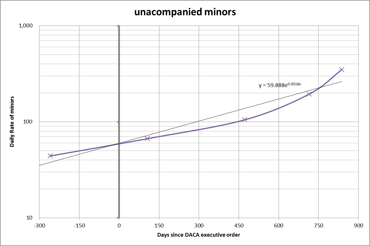 |
| Exploding rate of Unaccompanied Minors jumps from 60 to >200 per day |
Mexico: Law And Disorder
July 10, 2014: In the northeast (Tamaulipas state) police raided a location where 165 people from Cuba, Honduras, and El Salvador were being held captive by people smugglers who were demanding more money to get them into the United States. Such double dealing is common on the border, especially with non-Mexican migrants seeking someone who will get them across the border for a fee. Three of the kidnappers were arrested and the hostages said that one couple and their child had already been killed when they were unable to get anyone to produce more money for them.
Warning Signs: Mexico is Deliberately Aiding Illegal Aliens
Cause and Effect
The countries where these unaccompanied minors appear to come from have not suddenly changed, and the pressure to emigrate has been building for some time. DACA basically opened the safety valve on the pressure cooker.Obama’s Immigration Policy: Identify The Problem And Do Nothing | The Daily Caller
President Obama did get something right about the current
immigrations crisis. The root of the problem is not in the United
States, it is the miserable social and economic conditions in Guatemala,
El Salvador and Honduras. And, true to form, the Obama administration
has completely ignored the root problem – that is until it became a
political problem.
The statistics tell the tale. Guatemala, El Salvador and
Honduras are the poorest countries in the continental western hemisphere
with per capita incomes of less than $8,000 each (at purchasing power
parity) according to
the World Bank. Honduras’ per capita income is only $4,591. With the
exception of Nicaragua, all are much poorer than their neighbors (Mexico
has a per capita income of $16,463). Homicide rates are even worse,
with Honduras suffering a rate of 90 per 100,000. Guatemala and El
Salvador have rates
of 40 and 41, more than triple Costa Rica and Nicaragua. By comparison,
Mexico has a murder rate of 22 and the United States only 5.
The distribution of income in Central America
Latin America has the sad reputation of being one of the
most unequal regions in the world. All Latin American countries exhibit levels
of income inequality that exceed the average of each of the regions of the world
except sub-Saharan Africa, and 10 Latin American countries are among the 15
most unequal in the world (CEPAL 2011; Gasparini and Lustig 2011). The Central
American countries reproduce the high levels of inequality in the region. Medina
and Galvan (2008) use the statistical technique of optimum stratification to
classify Latin American countries into groups according to their Gini index of
per capita family income (for around 2005). Costa Rica and El Salvador are
located, along with Uruguay, among the countries with the lowest inequality in
Latin America. At the other extreme, Guatemala and Honduras are located among the
Latin American countries with the highest levels of inequality.
We document changes in income and earnings inequality in the five Central American countries from the early 1990 s to 2009. In the 1990s Costa Rica had the most equal distribution of income in Central America, and one of the most equal distributions of income in Latin America. At the other extreme, Guatemala, Honduras and Nicaragua were among the most unequal countries in Latin America. Inequality in El Salvador was between these extremes. Then, in the first decade of the 21st century inequality in El Salvador and Nicaragua decreased while inequality in Costa Rica , Guatemala and Honduras increased. By 2009 levels of inequality in El Salvador and Nicaragua were similar to those in Costa Rica. In this paper, we examine why income and earning inequality differs between the five Central American countries, and why inequality decreased in El Salvador and Nicaragua but increased in Costa Rica, Guatemala and Honduras .
DACA
Deferred Action for Childhood Arrivals - Wikipedia, the free encyclopediaDeferred Action for Childhood Arrivals (“DACA”) is a memorandum authored by the Obama administration on June 15, 2012. It was implemented by the Secretary of the Department of Homeland Security, Janet Napolitano. It directs U.S. Customs and Border Protection (CBP), U.S. Citizenship and Immigration Services (USCIS), and U.S. Immigration and Customs Enforcement (ICE) to practice prosecutorial discretion towards some individuals who immigrated to the United States as children and are currently in the country illegally.
A grant of deferred removal action does not confer lawful immigration status, alter an individual’s existing immigration status, or provide a path to citizenship.
Tuesday, July 8, 2014
Aviation authorities to brief industry this fall on UAV sense-and-avoid technologies
Aviation authorities to brief industry this fall on UAV sense-and-avoid technologies
Representatives of the U.S. Department of Defense (DOD), Federal Aviation Administration (FAA), National Aeronautics and Space Administration (NASA) and the Department of Homeland Security (DHS) will meet with industry to discuss UAV sense-and-avoid technologies on 28 and 29 Oct. 2014 at the John Hopkins Applied Physics Laboratory in Laurel, Md.
...
Committee members particularly are interested in technologies under development in industry that can reduce the cost, size, weight, and power for onboard detection of aircraft that not communicating with air traffic control authorities, such as radar, light detection and ranging (lidar), or other sensor technologies.
Representatives of the U.S. Department of Defense (DOD), Federal Aviation Administration (FAA), National Aeronautics and Space Administration (NASA) and the Department of Homeland Security (DHS) will meet with industry to discuss UAV sense-and-avoid technologies on 28 and 29 Oct. 2014 at the John Hopkins Applied Physics Laboratory in Laurel, Md.
...
Committee members particularly are interested in technologies under development in industry that can reduce the cost, size, weight, and power for onboard detection of aircraft that not communicating with air traffic control authorities, such as radar, light detection and ranging (lidar), or other sensor technologies.
Leidos builds Anti-Submarine Warfare Continuous Trail ACTUV for DARPA
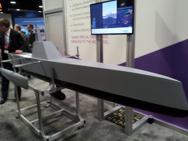 |
| ACTUV Model |
Anti-Submarine Warfare (ASW) Continuous Trail Unmanned Vessel (ACTUV)
Here’s How Darpa’s Robot Ship Will Hunt Silent Subs | Danger Room | WIRED
Video - Anti-Submarine Warfare (ASW) Continuous Trail Unmanned Vessel (ACTUV) Prototype - Naval Technology
The program has four phases.
- During phase 1, the program refined and validated the system concept and associated performance metrics,
completing risk reduction testing to inform program risks associated with
submarine tracking sensors and maritime autonomy. - In August 2012, DARPA awarded a contract for phases 2-4. The program plans the following in upcoming phases:
- Design a vessel (Phase 2);
- Build a vessel (Phase 3) and
- test the vessel (Phase 4).
An autonomous unmanned vessel designed to track quiet diesel-electric submarines spanning miles of ocean depths for months at a time with minimal human input is now under construction and is expected to set sail for testing in 2015. Leidos (NYSE: LDOS), a national security, health and engineering solutions company, has begun construction on Anti-Submarine Warfare (ASW) Continuous Trail Unmanned Vessel (ACTUV) under a Defense Advanced Research Project Agency (DARPA) program for the design, development, and construction of a vessel originally conceived for an anti-submarine warfare mission.
"ACTUV's advanced sensor technology should allow for continuous surveillance which, combined with the vessel architecture and design, is expected to provide autonomous safe navigation supporting Navy missions around the world," said Leidos Group President, John Fratamico.
ACTUV carries other sensors and mission packages designed to allow it to conduct a variety of Intelligence, Surveillance and Reconnaissance and other alternate missions. With situational sensors that can ensure safe navigation, the ACTUV trimaran has electro optics, long range and short range radar.
Monday, July 7, 2014
Army seeks drastic reductions in the size and power consumption of embedded GPS modules

The GB-GRAM is designed for ground use and low performance aircraft where tight integration with an IMU is not needed such as military SUAV's, e.g., RQ-11B Raven UAS navigates using Rockwell Collins GB-GRAM-M GPS receiver - Military Embedded Systems see also:
What’s Cooking at the Unmanned Aircraft Show in DC? : GPS World provides a list of small GPS units used in UAV.
ABERDEEN PROVING GROUND, Md., 24 June 2014. U.S. Army navigation experts are seeking (W56KGY-14--C008) drastic reductions in the size, weight, and power consumption (SWaP) of embedded GPS satellite navigation modules for use in future wearable and handheld computing, communications, and navigation devices for infantry soldiers.
- General. The Mini-GRAM-M is a form factor that provides at least one serial data interface using the standard interface protocol defined in ICD-GPS-153, as well as AN/PSN-11 TOD output, DS-101 (RS-485 mode).
- Physical. Mini-GRAM-M is not to exceed nominal size 1.5 x 1.5 x 0.5 inches.
- Weight. The total weight shall not exceed 50 grams.
- Input/Output Data. The requirement to provide interfaces is IAW IS-GPS-153D with M-code updates (e.g. MSID).
- Power. The Mini-GRAM-M shall have a power consumption rate at 900 mW (T) and 500 mW (O).
The Mini-GRAM-M GPS module, moreover, must weigh no more than 50 grams, and use no more power than 900 milliwatts in transmission mode, no more than 500 milliwatts in receive mode, and have fewer than 30 pins for I/O. The ultra-small-form-factor Mini GRAM-M GPS module must be compliant to P(Y), M-Code, and C/A (YMCA).
Certifying Military GPS Past, Present & Future - Milt Clary 2007-04-23.pdf
Also see patent Coherent processing using composite codes.
 |
| Modernized Military v. Current Civil GPS Signals |
The Mini-GRAM-M must be an M-Code GPS receiver that can be embedded into a wearable or handheld device for infantry soldiers, and installed to a circuit card such that it can substitute for an SSI-GB-GRAM in the Type II.
 |
| SSI-GB-GRAM Envelope |
SSI-GB-GRAM units
Rockwell Collins manufactures Miniature PLGR Engine - Selective Availablity Antispoofing Module; the MPE-S meets the GB-GRAM specification. It can be assumed they will be a primary contender for this. The interface has been customized to provide carrier phase information for precision navigation, as described by Sandia in their SAR radars.Raytheon has the Miniature Airborne GPS Receiver (MAGR) 2000 and MAGR 2000 SAASM.

The MAGR 2000 design is a GPS Receiver Applications Module (GRAM) based open system architecture that is modular in design and incorporates modern electronics. The MAGR 2000 is a form, fit, and function backward compatible replacement of the MAGR, and provides enhancements including improved acquisition and GPS solution performance, all-in-view GPSsatellite tracking and GPS integrity. MAGR 2000 includes a SAASM upgrade.
Small Commercial units
Commercial units aren't SAASM compliant, or handle Y & M code, but are small and cheap.Roadcomm also makes a very small unit: Roadcomm - GPS Mini Preview A.pdf.The RoadComm GPS module is a full function, high performance GPS receiver with embedded antenna designed for OEM system applications. The module will track up to twelve satellites at a time while providing one-second navigation information updates. This module utilizes the latest technology and high level circuit integration to achieve superior performance, small dimension and low power
consumption. RoadComm GPS module connects to host system through standard serial port (RS-
232) thus no longer requires expensive and hard to handle RF cable and connectors. The internal
memory backup allow it to retain data such as satellite orbital parameters,last position, data and time. It is still too big.
Ultimate GPS Module - 66 channel w/10 Hz updates [MTK3339 chipset] ID: 790 - $29.95 : Adafruit Industries, Unique & fun DIY electronics and kits
Ultimate GPS Module - 66 channel w/10 Hz updates [MTK3339 chipset] ID: 790 - $29.95 : Adafruit Industries, Unique & fun DIY electronics and kits
Sunday, July 6, 2014
10 RF interview questions
10 RF interview questions and answers | RF Questionnaire
See how many you could answer before checking the answers.
See how many you could answer before checking the answers.
-
What is the Return loss and VSWR?
How are they related, pls. explain?
-
What is 1dB compression point and 3rd order intercept point?
What is the relation between both?
- Why is the isolator placed at the output of the amplifier?
- What is carrier to interference ratio(C/I) and how it is related to SNR?
- What is G/T of the antenna?
- Explain difference between RF circulator and isolator.
-
Explain the transmission mode for EM waves in microstrip line.
Also explain types of microstrip line. -
What is the difference between harmonics and spurious?
When these signals are generated in RF circuit? -
What is image frequency rejection in RF transceiver?
What is the difference between homodyne and heterodyne architecture in RF Receiver? - What is the relation between dBm, dBW and Watt?
Friday, July 4, 2014
ADS launches Radar Constellation Challenge with HisdeSAT


The initiative is part of the Earth monitoring Copernicus Masters Competition, which aims to support the development of market-oriented applications based on Earth observation data.
The focus of the challenge is the creative utilization of high-resolution SAR (synthetic aperture radar) data specifically from the upcoming TerraSAR-X / TanDEM-X and PAZ constellation.
Subscribe to:
Posts (Atom)