The Nature of Speckle Noise
Speckle noise - Wikipedia, the free encyclopedia
Speckle is a granular 'noise' that inherently exists in and degrades the quality of the active
radar,
synthetic aperture radar (SAR), and
medical ultrasound images.
The vast majority of surfaces, synthetic or natural, are extremely
rough on the scale of the wavelength. Images obtained from these
surfaces by coherent imaging systems such as laser, SAR, and ultrasound
suffer from a common phenomena called speckle. Speckle, in both cases,
is primarily due to the interference of the returning wave at the
transducer aperture. The origin of this noise is seen if we model our
reflectivity function as an array of scatterers. Because of the finite
resolution, at any time we are receiving from a distribution of
scatterers within the resolution cell. These scattered signals add
coherently; that is, they add constructively and destructively depending
on the relative phases of each scattered waveform. Speckle noise
results from these patterns of constructive and destructive interference
shown as bright and dark dots in the image
[1]
Speckle noise in SAR is generally serious, causing difficulties for image interpretation.
[2][3]
It is caused by coherent processing of backscattered signals from
multiple distributed targets. In SAR oceanography, for example, speckle
noise is caused by signals from elementary scatterers, the
gravity-capillary ripples, and manifests as a pedestal image, beneath the image of the sea waves.
[4][5]
The speckle can also represent some useful information, particularly when it is linked to the
laser speckle and to the
dynamic speckle phenomenon, where the changes of the
speckle pattern, in time, can be a measurement of the surface's activity.
Speckle Noise Reduction
Several different methods are used to eliminate speckle noise, based upon different mathematical models of the phenomenon.
[4] One method, for example, employs
multiple-look processing (a.k.a.
multi-look processing), averaging out the speckle noise by taking several "looks" at a target in a single radar sweep.
[2][3] The average is the
incoherent average of the looks.
[3]
A second method involves using
adaptive
and non-adaptive filters on the signal processing (where adaptive
filters adapt their weightings across the image to the speckle level,
and non-adaptive filters apply the same weightings uniformly across the
entire image). Such filtering also eliminates actual image information
as well, in particular high-frequency information, and the applicability
of filtering and the choice of filter type involves tradeoffs. Adaptive
speckle filtering is better at preserving edges and detail in
high-texture areas (such as forests or urban areas). Non-adaptive
filtering is simpler to implement, and requires less computational
power, however.
[2][3]
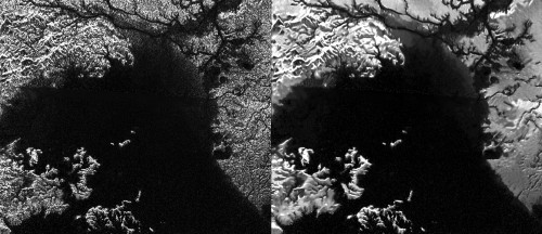
Improving Titan SAR Images with Probabilistic Despeckle
 |
Radar view of Ligeia Mare, a large hydrocarbon sea on Titan.
The
original version is on the left and the enhanced,
“despeckled” version
is on the right.
Image Credit: NASA/JPL-Caltech/ASI |
New Technique Provides Better, Clearer Radar Images of Titan’s Amazing Surface « AmericaSpace
Saturn’s largest moon Titan is a fascinating world, uniquely alien yet
eerily Earth-like in many ways, with its rain, rivers, lakes, seas, and
massive sand dunes. But in this extremely cold environment, it is liquid
methane and ethane which act as “water,” mimicking the hydrological
cycle on Earth. Also, due to the perpetual and global hazy cloud cover,
the only way to see these features from orbit is by using radar, which
is what the Cassini spacecraft has done on a regular basis for quite a
few years now. As good as they are, though, the radar images contain
electronic [speckle] noise, which reduces sharpness and clarity. But now a new technique is letting planetary scientists see Titan’s surface more clearly than ever before.
The technique is referred to as “despeckling” and produces cleaner
images than the original radar images from the Cassini Synthetic
Aperture Radar (SAR) instrument on Cassini. It uses an algorithm to
modify the noise in the images, making it easier to see small-scale
features or changes in the landscape. The idea was initiated by Antoine Lucas while he was working with members of the Cassini imaging team. He
was a postdoctoral researcher at the California Institute of Technology
in Pasadena at the time.
A New Way to View Titan: 'Despeckle' It | NASA
New imaging technique reveals Titan in unprecedented detail | Astronomy Now
Despeckling Cassini’s radar images has a variety of scientific benefits.
Lucas and colleagues have shown that they can produce 3-D maps, called
digital elevation maps, of Titan’s surface with greatly improved
quality. With clearer views of river channels, lake shorelines and
windswept dunes, researchers are also able to perform more precise
analyses of processes shaping Titan’s surface. And Lucas suspects that
the speckle noise itself, when analysed separately, may hold information
about properties of the surface and subsurface.
A despeckle filter for the Cassini synthetic aperture radar images of Titan's surface BRATSOLIS_PSS_2012.pdf
Cassini synthetic aperture radar (SAR) images of Titan, the largest satellite of Saturn, reveal surface features with shapes ranging from quasi-circular to more complex ones, interpreted as liquid hydrocarbon deposits assembled in the form of lakes or seas. One of the major problems hampering the derivation of meaningful texture information from SAR imagery is the speckle noise. It overlays real structures and causes gray value variations even in homogeneous parts of the image. We propose a filtering technique which can be applied to obtain restored SAR images. Our technique is based on probabilistic methods and regards an image as a random element drawn from a prespecified set of possible images. The despeckle filter can be used as an intermediate step for the extraction of regions of interest, corresponding to structured units in a given area or distinct objects of interest, such as lake-like features on Titan. This tool can therefore be used, among other, to study seasonal surficial changes of Titan’s polar regions. In this study we also present a segmentation technique that allows us to separate the lakes from the local background.
Other Recent work on Probabilistic Despeckle
Abstract
A method for synthetic aperture
radar (SAR) image despeckling based on a probabilistic generative model
in nonsubsampled contourlet transform (NSCT) domain was proposed. The
shrinkage estimator in NSCT domain consists of a new type of likelihood
ratio and prior ratio, both of which are dependent on the estimated
masks for the NSCT coefficients. While the previous probabilistic
approaches are restricted to parametric models, the limitation is
eliminated and the hybrid density model is applied in this paper. The
suggested approach does not make heavy assumptions on the NSCT
coefficient distribution, so that it can handle complex NSCT coefficient
structures. The likelihood ratio is composed of the hybrid density, and
the prior ratio is equipped with the selective neighborhood systems to
enhance the detail information. The method can effectively adapt the
shrinkage estimator to the redundancy property of the NSCT. The proposed
approach was applied to real SAR images despeckling and compared
through the SAR image vision effect, the equivalent number of looks, and
the edge sustain index. Experimental results show that the proposed
approach outperforms previous works involved in the paper with the
better despeckling result and edge preservation.
Walessa, M.; Datcu, M., "Model-based despeckling and information extraction from SAR images,"
Geoscience and Remote Sensing, IEEE Transactions on , vol.38, no.5, pp.2258,2269, Sep 2000
doi: 10.1109/36.868883
Abstract:
Basic textures as they appear, especially in high resolution SAR
images, are affected by multiplicative speckle noise and should be
preserved by despeckling algorithms. Sharp edges between different
regions and strong scatterers also must be preserved. To despeckle
images, the authors use a maximum aposteriori (MAP) estimation of the
cross section, choosing between different prior models. The proposed
approach uses a Gauss Markov random field (GMRF) model for textured
areas and allows an adaptive neighborhood system for edge preservation
between uniform areas. In order to obtain the best possible texture
reconstruction, an expectation maximization algorithm is used to
estimate the texture parameters that provide the highest evidence.
Borders between homogeneous areas are detected with a stochastic
region-growing algorithm, locally determining the neighborhood system of
the Gauss Markov prior. Smoothed strong scatterers are found in the
ratio image of the data and the filtering result and are replaced in the
image. In this way, texture, edges between homogeneous regions, and
strong scatterers are well reconstructed and preserved. Additionally,
the estimated model parameters can be used for further image
interpretation methods
URL:
http://ieeexplore.ieee.org/stamp/stamp.jsp?tp=&arnumber=868883&isnumber=18811
Previously
spendergast: Cassini SAR Radar tracks Evolution of Mysterious Feature in Titan Sea