Monday, January 25, 2016

Medical Device QSR Design Controls

Guidance Documents (Medical Devices and Radiation-Emitting Products)
> Design Control Guidance For Medical Device Manufacturers
Design control FDA requirements
eCFR — Code of Federal Regulations

§820.30   Design controls.

(a) General. (1) Each manufacturer of any class III or class II device, and the class I devices listed in paragraph (a)(2) of this section, shall establish and maintain procedures to control the design of the device in order to ensure that specified design requirements are met.
(2) The following class I devices are subject to design controls:
(i) Devices automated with computer software; and
(ii) The devices listed in the following chart.
SectionDevice
868.6810Catheter, Tracheobronchial Suction.
878.4460Glove, Surgeon's.
880.6760Restraint, Protective.
892.5650System, Applicator, Radionuclide, Manual.
892.5740Source, Radionuclide Teletherapy.


Reviews of Cognition Cockpit : Free Pricing & Demos : Requirements Management Software
Cognition Cockpit is an intuitive, web-based application empowering the Product Development Process (PDP). Cockpit enables teams to collaboratively manage customer inputs and voices, features and requirements, risks, costs, and critical parameters. Cockpit uses the best practices from systems engineering and risk and requirements management. Cockpit also helps with the 21 CFR 820.30 Design Control Process. Features include instant traceability, analysis, and reporting.

Take Charge of Medical Device Design Control Regulations with Cognition's New White Paper Series

As each piece of 820.30 is created, there is a need to show traceability. Cognition Cockpit automatically puts the trace together using the information added by each user. The design input and design output engineers do not need to have a face to face meeting for a merging of work processes. Cockpit’s linking ability puts all the pieces into one trace matrix. A trace matrix is generated out of Cockpit into a document showing connectivity between each component of 820.30. All of the UIs in the project are listed in the trace. The trace could also show unique attributes of the UI if desired. The next column displays all of the design inputs connected to a UI. The third column shows the design outputs of the design inputs. Included in the last column are the verifications. This case did not include either validations or user needs, but those could be easily thrown into the trace as well.

Related/Background:

Sunday, January 24, 2016

Russia, China team for "BG Star" Satellite Navigation Chip Set for BRICS/SCO

China Has Its Own GPS Now—And It's Better Than ours
China and Russia jointly developed Beidou navigation chip | a brand for the BG-Star @ goodchinabrand.com
Gu Erke stressed: 'It is estimated that a company will be set up in the' Skolkovo 'science city, [Inside Skolkovo, Moscow's self-styled Silicon Valley | Cities | The Guardian] which will be responsible for the development of the chip itself, the second enterprise will be responsible for the production and sale of our ongoing negotiations, taking into account. 'Skolkovo' tax incentives, hoping to chip development work can be carried out in Russia, and the production and sale of work by the Chinese counterparts may be responsible. The problem is that Russia has no modern means for products containing nano-receiver 40, and this In the near future it is unpredictable. So China's experience in this regard is necessary for us. '
He explained that will support Beidou navigation receiver, GLONASS and GPS signals.
Gu Erke said: 'We also plan to use behind European' Galileo 'navigation system, according to him, the main market of the new device are China and Russia, the future will be the third country market output.
He said: 'This device is not used for smart phones, but nor is it used for high-precision positioning systems for telematics terminal for GLONASS - Era (Era-Glonass) and eCall, ie. Various types of traffic management China intends to use the Russian experience in the manufacture of emergency response systems, because we identified our European partners on this project: eCall system, which will be put into operation in 2018, and our system is already in use. 2017 onwards planned to install the system mandatory on all new cars in circulation within the range of a customs union. '

Russia, China to Finalize Satellite Navigation Chip Set Deal by Year-End
The Bei-Dou-GLONASS-GPS device will operate under the "BG-Star" brand on Russian and Chinese markets, with plans to expand further, Gurko said.
One of the ventures is expected to develop the chip set at Russia's Skolkovo Innovation Center, the other based in China and involved in manufacturing and sales, according to the GLONASS Union president.


China Official: BeiDou Gear Will Receive other GNSS Signals
In an address here to the Paris Space Week conference, organized by ASTech Paris Region and Proximum Group, the Chinese official said China’s early deployment of satellite navigation terminals for precision agriculture already feature multimode GPS-Beidou receivers.
Asked whether that would continue as Beidou expands from its current regional focus, Chen Zhi, deputy chief designer of the China Aerospace Science and Industry Corp., said chipsets would receive Europe’s Galileo and Russia’s Glonass signals as well.
Beidou currently operates with 14 in-orbit satellites and covers the whole of China and the surrounding region. The full constellation is designed to comprise 35 satellites – five in geostationary orbit 36,000 kilometers over the equator, three in inclined-geostationary orbit and 27 in medium Earth orbit.
- See more at: http://spacenews.com/china-official-beidou-gear-will-receive-u-s-russian-and-european-gnss-signals/#sthash.5mjTVq72.dpuf
In an address here to the Paris Space Week conference, organized by ASTech Paris Region and Proximum Group, the Chinese official said China’s early deployment of satellite navigation terminals for precision agriculture already feature multimode GPS-Beidou receivers.

Asked whether that would continue as Beidou expands from its current regional focus, Chen Zhi, deputy chief designer of the China Aerospace Science and Industry Corp., said chipsets would receive Europe’s Galileo and Russia’s Glonass signals as well.

Beidou currently operates with 14 in-orbit satellites and covers the whole of China and the surrounding region. The full constellation is designed to comprise 35 satellites – five in geostationary orbit 36,000 kilometers over the equator, three in inclined-geostationary orbit and 27 in medium Earth orbit. 

MIT Algorithm finds way through for UAVs in real time

MIT Demos Route Planning Algorithm - Drones Avoid Obstacles On The Fly | CrazyEngineers
researcher and PhD student Anirudha Majumdar set up a forest-like cluttered space using pvc pipes and strings. The drone they chose was a quadrotor, 3.5 inches wide, weighing an ounce and capable of doing a little more than 1 meter per second. The video shows how the drone was able to put up a fine air show by changing courses and flipping on the fly.


Anirudha Majumdar explained how complicated drone flight algorithms can get, by numbering the different directions a flying object might have to change its directions in order to avoid collision. Apparently, the algorithm needs to constantly analyze 12 parameters to determine the drone’s exact location in space and how fast it is moving, while monitoring the obstacles simultaneously.
Watch drones do donuts around obstacles thanks to planning algorithms | MIT CSAIL

Majumdar’s software, generates conservative plans, and can do so in real-time. He first developed a library of 40 to 50 trajectories that are each given an outer bound that the drone is guaranteed to remain within. These bounds can be visualized as ”funnels” that the planning algorithm chooses between to stitch together a sequence of steps that allow the drone to plan its flying on the fly.
A flexible approach like this comes with a high level of guarantees that the software will work, even in the face of uncertainties with both the surroundings and the hardware itself. The algorithm can easily be extended to drones of different sizes and payloads, as well as ground vehicles and walking robots.
As for the environment, imagine the drone choosing between making a forceful roll maneuver that will avoid a tree by a large margin, versus flying straight and avoiding a tree by a small amount.
“A traditional approach might prefer the first since avoiding obstacles by a significant amount seems ‘safer,’” Majumdar says. “But a move like that actually may be riskier because it’s more susceptible to wind gusts. Our method makes these decisions in real-time, which is critical if we want drones to move out of the labs and operate in real-world scenarios.”

Related/Background:

  • In Press | Anirudha Majumdar 
  • Anirudha Majumdar and Russ Tedrake, “Funnel Libraries for Real-Time Robust Feedback Motion Planning,” In Preparation, 2016. ArXiv preprint: http://arxiv.org/abs/1601.04037 
  • Anirudha Majumdar and Russ Tedrake, “Robust Online Motion Planning with Regions of Finite Time Invariance,” Workshop on the Algorithmic Foundations of Robotics, 2012. [.pdf]  x

Friday, January 22, 2016

Quality Healthcare Performance Metrics key to effective Systems Engineering Application

Federal Register | Medicare and Medicaid Programs; CY 2016 Home Health Prospective Payment System Rate Update; Home Health Value-Based Purchasing Model; and Home Health Quality Reporting Requirements
Performance Managment
Rating the Raters: The Inconsistent Quality of Health Care... : Annals of Surgery

Rating the Raters: The Inconsistent Quality of Health Care Performance Measurement.

Shahian, David M. MD; Normand, Sharon-Lise T. PhD; Friedberg, Mark
W. MD, MPP; Hutter, Matthew M. MD, MPH; Pronovost, Peter J. MD, PhD

THE PROBLEM OF FLAWED METHODOLOGY
Given the analytical complexity of health care outcomes measures and lack of widely accepted and enforceable standards, flawed or inconsistent rating methodologies are neither surprising nor rare.5–12  In some instances, different rating organizations have produced completely divergent ratings for the same hospital during the same rating period, and patients have no way of knowing which are more accurate and relevant to their needs.

Contrary to the aphorism that ‘‘any data are better than no data,’’ bad data or methodology can often be worse than no data, and can produce serious unintended consequences. They misclassify doctors and hospitals, misinform and confuse the public, and squander increasingly scarce resources. Inaccurate report cards can mislead patients into seeking care from providers falsely labeled as above average in performance, or steer patients away from truly excellent providers mistakenly identified as low performing. Providers incorrectly categorized as below average may divert resources to address alleged but nonexistent quality issues, whereas truly low performing providers are lulled into complacency. Based on faulty reports, payers may reward low-performing providers or penalize true high performers. Ultimately, flawed report cards foster cynicism and distrust of all performance measurement.


There are enough healthcare quality measures - Modern Healthcare Modern Healthcare business news, research, data and events

It doesn't matter how much healthcare providers and researchers rail about the inadequacy and inconsistency of the consumer ratings offered by the CMS, the Leapfrog Group, journalism outfits and online startups. They are not only here to stay, they are proliferating.

Last week, Yelp, best known for its consumer reviews of restaurants, teamed up with ProPublica, a not-for-profit investigative journalism group, to rate nursing homes. It's the first of what promises to be a series of partnerships linking hard data to consumer ratings in healthcare.

On Yelp's newest online tool, if an elderly person or family member searches for nursing homes by ZIP code or city, not only can they read individual consumer reviews about their experiences, they also can get instantaneous readouts of the homes' histories of receiving excessive fines or whether they had ever been suspended for poor performance by the CMS. They can even read each home's biannual inspections reports.

That came less than a month after ProPublica stirred outrage among the nation's surgeons by releasing an independent analysis of Medicare-derived data on 16,810 surgeons. The group's online search tool allows consumers to look up how many times each surgeon performed one or more of eight common procedures; how many complications occurred; and where that surgeon's complication rate ranked on a national scale.

Over the next few months, you can expect articles in medical and health policy literature blasting ProPublica's focus on the limited data of individual surgeons without adequate risk adjustment. “It goes against everything we're trying to do in the patient-safety movement,” lamented one surgeon, who focuses on improving the systems within which surgeons operate.

Memo to hospital officials, physicians and other providers: Consumers and patients don't read the scientific and policy literature.

Background/Related:

Wednesday, January 20, 2016

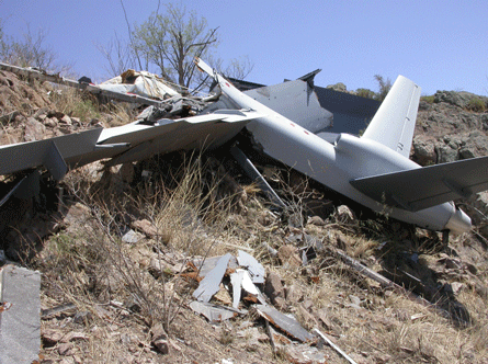
Reapers crashing due to fault in starter-generator

The Pentagon’s most advanced drone keeps falling out of the sky - Business Insider
Ten Reapers were badly damaged or destroyed in 2015, at least twice as many as in any previous year, according to Air Force safety data.
The Reaper's mishap rate — the number of major crashes per 100,000 hours flown — more than doubled compared with 2014. The aircraft, when fully equipped, cost about $14 million each to replace.
 
More Air Force drones are crashing than ever as mysterious new problems emerge - The Washington Post

The Reaper has been bedeviled by a rash of sudden electrical failures that have caused the 21/2-ton
drone to lose power and drop from the sky, according to accident-investigation documents obtained under the Freedom of Information Act. Investigators have traced the problem to a faulty starter-generator, but have been unable to pinpoint why it goes haywire or devise a permanent fix.

All told, 20 large Air Force drones were destroyed or sustained at least $2 million in damage in accidents last year, the worst annual toll ever, according to a Washington Post investigation. The Pentagon has shrouded the extent of the problem and kept details of most of the crashes a secret.


Drone Crash Database – Drone Wars UK

Drone Wars UK began compiling details of military drone crashes in 2010. Our database cover crashes of large (Class II and III) military drones since 01 Jan 2007. It has been compiled from USAF
Accident Investigation Board (AIB) Reports, the Wikileaks War Logs, The Washington Post US drone crash database and reports from the general and military press.

Air Force: Depleted batteries, failed generator caused MQ-9 Reaper crash
 A previously undisclosed MQ-9 Reaper crash in the Central Command area of responsibility was caused by the armed drone's depleted backup batteries and generator failure, according to an Air Force investigation report released Thursday.

Air Force “Reaper” Drones Keep Mysteriously Crashing | Inverse

Friday, January 15, 2016

USN and MDA ok Aegis BL 9.C1 for BMD

Aegis Ballistic Missile Defense Media Gallery
US Navy Certifies Latest Capabilities of Aegis Combat System
The U.S. Navy and Missile Defense Agency (MDA) certified the latest evolution of the Aegis Combat System – called Baseline 9.C1 – for the U.S. destroyer fleet. The Aegis baseline, built by Lockheed Martin (NYSE: LMT) offers advanced defense capabilities and enhanced integration with other systems external to the ship.
“The Aegis Combat System Baseline 9.C1 offers unprecedented capabilities, including simultaneous air and ballistic missile defense,” said Jim Sheridan, Lockheed Martin director of Aegis programs. “This Aegis baseline also improves Aegis networking capabilities, allowing Aegis vessels to automatically coordinate defense with input from satellite and ground-based radar assets—forming a true shield of defense over a wide area.”

Background/Related:

#Prostate #Cancer News - 2016-01-15


Prostate Cancer News - 2016-01-15


General Case Management

Choices you Make

Screening and Diagnosis

Biopsies, Genomics and Pathology

Tests

World renowned Robotic prostate cancer surgeon in New York supports new study... -- NEW YORK, Jan. 12, 2016 /PRNewswire/ --
PSA test has a place in treating prostate cancer : Lifestyles

Imaging

Access : In vivo prostate cancer detection and grading using restriction spectrum imaging-MRI : Prostate Cancer and Prostatic Diseases
Multiparametric MRI for Prostate Cancer Localization and Characterization Using Hyperpolarized Pyruvate (13C) Injection

Treatment

Active Surveillance

Development of a standardized commercial test to “score” patients as eligible for active surveillance | THE "NEW" PROSTATE CANCER INFOLINK
'Very Big Deal': NCCN Okays Watching More Prostate Cancer

Surgery

Radiation

Hypofractionated Intensity Modulated and Image Guided Radiotherapy for Localized Prostate Cancer
Lower-Dose RT New Standard for Prostate Cancer? | Medpage Today
Site of cancer recurrence after first-line (primary) radiation therapy | THE "NEW" PROSTATE CANCER INFOLINK
Salvage SBRT for local recurrence after first-line (primary) radiation therapy | THE "NEW" PROSTATE CANCER INFOLINK

Hormone

Adding Hormonal Tx To Salvage RT Ups Prostate Ca Survival | Medpage Today

Chemo

New Techniques

New prostate cancer treatment offers non-surgical alternative | abc7.com
Targeting Tumors: A New Strategy for Prostate Cancer Treatment
Therapy Seeks and Destroys Prostate Cancer in Mice

Side Effects

Expectation management and sexual/erectile outcomes after radical prostatectomy | THE "NEW" PROSTATE CANCER INFOLINK
The Effects of Pilates in Muscle Strength of the Pelvic Floor as Treatment of Post Prostatectomy Urinary Incontinence

Advanced/Recurrence

Even after anti-androgen therapy, docetaxel remains useful in prostate cancer - Medical News Today
'Bipolar' Therapy: New Twist in Advanced Prostate Cancer

Tuesday, January 12, 2016

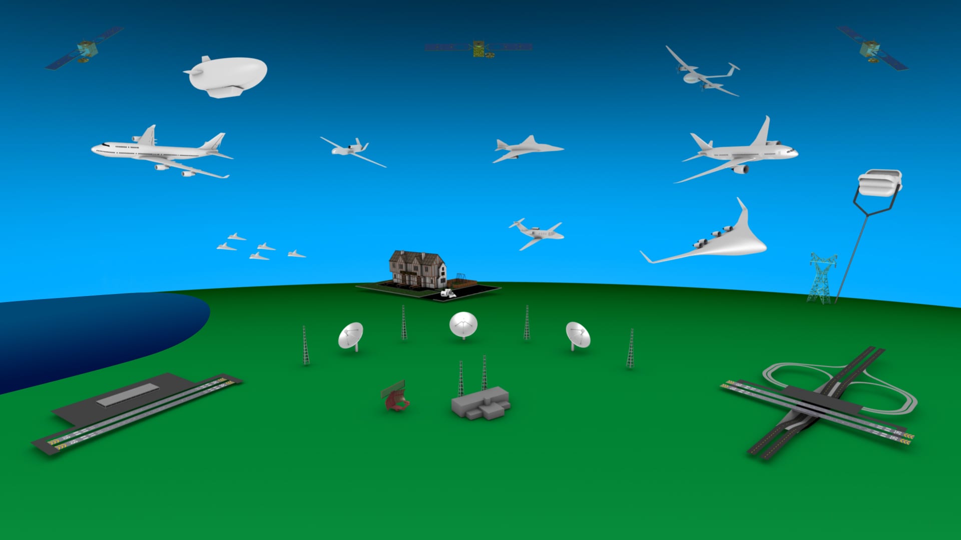
NASA AMES seeks help testing UAS safety systems

NASA launches competition for airspace redesign
A--UNMANNED AERIAL SYSTEM TRAFFIC MANAGEMENT COLLABORATIVE TESTING - Federal Business Opportunities: Opportunities

Title:              A--UNMANNED AERIAL SYSTEM TRAFFIC MANAGEMENT COLLABORATIVE TESTING
 Sol. #:             UTM01112016
 Agency:             National Aeronautics and Space Administration
 Office:             Ames Research Center
 Location:           Office of Procurement
 Posted On:          Jan 11, 2016 5:35 pm
 Current Type:       Special Notice (Modified)
 Base Type:          Special Notice
 Base Posting Date:  Jan 11, 2016 5:24 pm
 Link:               https://www.fbo.gov/spg/NASA/ARC/OPDC20220/UTM01112016/listing.html


NASA Ames Research Center (ARC), is hereby requesting information through this notice from interested parties for the following: NASAs Safe Autonomous Systems Operations (SASO) Project seeks to identify U.S.-based public, private, and academic organizations to collaborate with NASA to conduct Unmanned Aerial System (UAS) and UAS Traffic Management (UTM) research and development with the collective goal of safely enabling these operations at lower altitudes by UTM system. The collaboration will involve a series of UTM builds with evolving complexity. This notice also solicits interested parties' questions, comments, suggestions, clarifications, and any data that would help the agency prepare for such collaboration. There will be no funds exchanged between NASA and collaborating parties. 

Monday, January 11, 2016

New Book - Principles of SAR imaging : a system simulation approach / Kun-Shan Chen

Principles of Synthetic Aperture Radar Imaging: A System Simulation Approach - CRC Press Book
Kun-Shan CHEN

Author(s) Bio

Kun-Shan Chen received a PhD degree in electrical engineering from the University of Texas at Arlington in 1990. From 1992 to 2014, he was with the faculty of National Central University, Taiwan. He joined the Institute of Remote Sensing and Digital Earth, Chinese Academy of Science, in 2014, and has served the Department of Electrical Engineering, The University of Texas at Arlington, USA, as a research professor since 2014. He has authored or coauthored over 120 journal papers, contributed seven book chapters, is a coauthor of one book, and a fellow of The Institute of Electrical and Electronics Engineers (IEEE).

 December 18, 2015 by CRC Press
Reference - 203 Pages - 29 Color & 123 B/W Illustrations
ISBN 9781466593145 - CAT# K20597
Series: Signal and Image Processing of Earth Observations
CRCnetBASE - SAR Models 
UC San Diego /All Collec

Features

  • Includes numerical analysis of system parameters, including platforms, sensor, and image focusing, and their influences
  • Brings a large volume of samples of simulation on various scenarios to help readers resolve their own problems of interest
  • Explains in details the state-of-the-art of space-, air-borne, and ground-based systems, their different technical aspects and challenges to overcome
  • Presents novel processing algorithms and applications to feature extraction, target classification, and change detection

Summary

Principles of Synthetic Aperture Radar Imaging: A System Simulation Approach demonstrates the use of image simulation for SAR. It covers the various applications of SAR (including feature extraction, target classification, and change detection), provides a complete understanding of SAR principles, and illustrates the complete chain of a SAR operation.
The book places special emphasis on a ground-based SAR, but also explains space and air-borne systems. It contains chapters on signal speckle, radar-signal models, sensor-trajectory models, SAR-image focusing, platform-motion compensation, and microwave-scattering from random media.
While discussing SAR image focusing and motion compensation, it presents processing algorithms and applications that feature extraction, target classification, and change detection. It also provides samples of simulation on various scenarios, and includes simulation flowcharts and results that are detailed throughout the book.
Introducing SAR imaging from a systems point of view, the author:
  • Considers the recent development of MIMO SAR technology
  • Includes selected GPU implementation
  • Provides a numerical analysis of system parameters (including platforms, sensor, and image focusing, and their influence)
  • Explores wave-target interactions, signal transmission and reception, image formation, motion compensation
  • Covers all platform motion compensation and error analysis, and their impact on final image radiometric and geometric quality
  • Describes a ground-based SFMCW system
Principles of Synthetic Aperture Radar Imaging: A System Simulation Approach is dedicated to the use, study, and development of SAR systems. The book focuses on image formation or focusing, treats platform motion and image focusing, and is suitable for students, radar engineers, and microwave remote sensing researchers.

Reviews

"This book provides readers with a comprehensive and complete description of synthetic aperture radar principle. Its unique feature of full-blown SAR image simulations and modeling, including sensor and target location, targets geometric and radiometric scattering characteristics, and clutters from system and environment, distinguishes this book from other SAR processing books. Insightful and state of arts information on SAR trajectory, SAR focusing and motion compensation are clearly detailed. For the first time, satellite SAR systems, such as RadarSAT-2, TerraSAR-X and ALOS/PALSAR and their imaging configurations, are integrated into the simulation and modeling. One of the highlights of this book rests at image simulations of hard targets, such as B757-200, B747-400, A321 and MD80 for various aspect angles. These simulations make target identification possible as illustrated using real TerraSAR-X SAR images. This book can be used both as a reference book for SAR researchers and as a textbook for graduate students if exercises can be supplemented."
—Jon-Sen Lee, Naval Research Laboratory (Retired), Washington DC, USA

 Related/Background:

  • Chen, Chia-Tang; Kun-Shan Chen; Jong-Sen Lee, "The use of fully polarimetric information for the fuzzy neural classification of SAR images," in Geoscience and Remote Sensing, IEEE Transactions on , vol.41, no.9, pp.2089-2100, Sept. 2003
    doi: 10.1109/TGRS.2003.813494
    Abstract: Presents a method, based on a fuzzy neural network, that uses fully polarimetric information for terrain and land-use classification of synthetic aperture radar (SAR) image. The proposed approach makes use of statistical properties of polarimetric data, and takes advantage of a fuzzy neural network. A distance measure, based on a complex Wishart distribution, is applied using the fuzzy c-means clustering algorithm, and the clustering result is then incorporated into the neural network. Instead of preselecting the polarization channels to form a feature vector, all elements of the polarimetric covariance matrix serve as the target feature vector as inputs to the neural network. It is thus expected that the neural network will include fully polarimetric backscattering information for image classification. With the generalization, adaptation, and other capabilities of the neural network, information contained in the covariance matrix, such as the amplitude, the phase difference, the degree of polarization, etc., can be fully explored. A test image, acquired by the Jet Propulsion Laboratory Airborne SAR (AIRSAR) system, is used to demonstrate the advantages of the proposed method. It is shown that the proposed approach can greatly enhance the adaptability and the flexibility giving fully polarimetric SAR for terrain cover classification. The integration of fuzzy c-means (FCM) and fast generalization dynamic learning neural network (DLNN) capabilities makes the proposed algorithm an attractive and alternative method for polarimetric SAR classification.
    keywords: {fuzzy neural nets;image classification;radar imaging;radar polarimetry;synthetic aperture radar;terrain mapping;AIRSAR system;Jet Propulsion Laboratory Airborne SAR;SAR images;complex Wishart distribution;dynamic learning neural network;fuzzy c-means clustering algorithm;fuzzy neural network;image classification;land-use classification;polarimetric SAR classification;polarimetric backscattering information;polarimetric covariance matrix;polarimetric data;polarimetric information;polarization channels;speckle filtering;statistical properties;synthetic aperture radar;terrain classification;terrain cover classification;Backscatter;Clustering algorithms;Covariance matrix;Fuzzy neural networks;Image classification;Neural networks;Polarization;Propulsion;Synthetic aperture radar;System testing},
    URL: http://ieeexplore.ieee.org/stamp/stamp.jsp?tp=&arnumber=1232222&isnumber=27602

    Kun-Shan Chen; Hsiu-Wen Wang; Chih-Tien Wang; Wen-Yen Chang, "A Study of Decadal Coastal Changes on Western Taiwan Using a Time Series of ERS Satellite SAR Images," in Selected Topics in Applied Earth Observations and Remote Sensing, IEEE Journal of , vol.4, no.4, pp.826-835, Dec. 2011
    doi: 10.1109/JSTARS.2011.2131635
    Abstract: In this paper, coastal line changes were monitored and analyzed from a sequence of ERS-1/2 SAR images covering the years 1996 to 2005, totaling 44 images for each year. Waterlines were extracted using a multi-scale edge detection algorithm, and further refined by means of morphology. Substantial analysis was carried out in conjunction with ground survey and sonar bathymetric mapping. In addition, tidal records were used to ensure all the shore lines been calibrated to the same tidal level. Results showed that Waisanting Sandbar, a north-southward sandbar, experienced significant accretion and erosion, moving southward about 700 meters during a 10-year period, and shrinking to just one third of its 1996 size. The surrounding coastal waters and the estuary of the Peikang River receded substantially, moving inward toward the coastal flat. The water channel became even more heavily deposited as a result. Finally, Haifengdao Sandbar, another sandbar, moved southward about 1.5 km, although its size remained the same from 1996 to 2005. It also showed a clear tendency to receding inward. We conclude that satellite remote sensing by SAR, aided by ground tidal data, bathymetric maps, and optical images, provides an effective and efficient tool for understanding coastal processes over large areas of coverage and long time spans.
    keywords: {bathymetry;edge detection;geophysical image processing;oceanographic techniques;remote sensing by radar;rivers;synthetic aperture radar;tides;time series;AD 1996 to 2005;ERS satellite SAR image;ERS-1/2 SAR image;Haifengdao Sandbar;Peikang River estuary;Waisanting Sandbar;Western Taiwan;coastal water region;decadal coastal line change analysis;ground tidal data;multiscale edge detection algorithm;north-southward sandbar;optical image analysis;sonar bathymetric mapping method;tidal record analysis;time series;waterline region;Global Positioning System;Image edge detection;Remote sensing;Sea measurements;Sonar measurements;Costal change detection;SAR},
    URL: http://ieeexplore.ieee.org/stamp/stamp.jsp?tp=&arnumber=5766783&isnumber=6086909

    Cheng-Yen Chiang; Kun-Shan Chen; Chih-Tien Wang; Nien-Shiang Chou, "Feature Enhancement of Stripmap-Mode SAR Images Based on an Optimization Scheme," in Geoscience and Remote Sensing Letters, IEEE , vol.6, no.4, pp.870-874, Oct. 2009
    doi: 10.1109/LGRS.2009.2028038
    Abstract: Based on a nonquadratic-optimization method originally proposed for spotlight-mode SAR image reconstruction, a modification for stripmap-mode SAR images is presented in this letter. This is done by mathematically reformulating the projection kernel and numerically putting it into a form that is suitable for optimization. The performance was evaluated by measures of the target contrast and 3-dB beamwidth using Radarsat-1 data. Results were analyzed and compared with those using minimum-variance and multiple-signal-classification methods. Results demonstrate that the target's features are effectively enhanced and that the dominant scattering centers are well separated using the proposed method. In addition, the image fuzziness is greatly reduced, and the image fidelity is well preserved. The effectiveness of the modification is thus validated.
    keywords: {image enhancement;image reconstruction;optimisation;radar imaging;synthetic aperture radar;feature enhancement;multiple-signal-classification method;nonquadratic-optimization method;stripmap-mode SAR image;synthetic aperture radar;Feature enhancement;minimum variance (MV);multiple signal classification (MUSIC);stripmap SAR;synthetic aperture radar (SAR)},
    URL: http://ieeexplore.ieee.org/stamp/stamp.jsp?tp=&arnumber=5233873&isnumber=5278412

    Tzeng, Y.C.; Chen, K.S., "A fuzzy neural network to SAR image classification," in Geoscience and Remote Sensing, IEEE Transactions on , vol.36, no.1, pp.301-307, Jan 1998
    doi: 10.1109/36.655339
    Abstract: Recently, neural networks have been increasingly applied to remote sensing imagery classification. The conventional neural network classifier performs learning from the representative information within a problem domain on a one-pixel-one-class basis; therefore, class mixture and the degree of membership of a pixel are generally not taken into account, often resulting in a poor classification accuracy. Based on the framework of a dynamic learning neural network (DL), this communications proposes a fuzzy version (FDL) based on two steps: network representation of fuzzy logic and assignment of membership. Comparisons between the DL and FDL are made by applying both neural networks to SAR image classification. Experimental results show that the FDL has faster convergence rate than that of DL. In addition, the separability between similar classes is improved. Moreover, the classification results match better with ground truth
    keywords: {fuzzy neural nets;geophysical signal processing;geophysical techniques;geophysics computing;image classification;radar imaging;remote sensing by radar;synthetic aperture radar;SAR;classifier;dynamic learning neural network;fuzzy logic;fuzzy neural network;fuzzy version;geophysical measurement technique;image classification;land surface;network representation;neural net;radar imaging;radar remote sensing;synthetic aperture radar;terrain mapping;Convergence;Fuzzy logic;Fuzzy neural networks;Fuzzy set theory;Fuzzy sets;Image classification;Neural networks;Remote sensing;Space technology;Testing},
    URL: http://ieeexplore.ieee.org/stamp/stamp.jsp?tp=&arnumber=655339&isnumber=14284

    Jin Min Kuo; Chen, K.-S., "The application of wavelets correlator for ship wake detection in SAR images," in Geoscience and Remote Sensing, IEEE Transactions on , vol.41, no.6, pp.1506-1511, June 2003
    doi: 10.1109/TGRS.2003.811998
    Abstract: The detection of the wake can provide substantial information about a ship, such as its size, direction, and speed of movement. In general though, ship-generated wakes in synthetic aperture radar images are associated with high sea clutter, which will cause some deterioration in the detection performance. Therefore, a wavelet correlator, based on an orthogonal basis function, is adopted. Three highpass images - horizontal, vertical, and diagonal direction - are generated for each resolution scale, followed by a process to correlate among the moduli of different scale modulus images formed from the three highpass images. The output of the correlation process is highly representative at the ship's wake edges. Comparisons with other methods indicate the superior performance of the present approach, in that not only can the wakes be detected, but their V-shaped pattern is well preserved. The second stage involves the application of the Radon transform technique to an estimation of the V-opening angle from the detected ship wakes. Ship-generated wake edges are found to be the local maxima in the wavelet transform method of several adjacent scales, and hence, the wake edge will be enhanced in the reconstructed data. The background noise is also greatly reduced. In particular, the process of spatial correlation is found to be critical. Compared to a direct Radon transform, the proposed scheme is demonstrated to be much more effective in terms of efficiency, as well as reliability, for ship wake detection in noisy backgrounds.
    keywords: {Radon transforms;oceanographic techniques;radar clutter;remote sensing by radar;synthetic aperture radar;wakes;wavelet transforms;Radon transform technique;SAR images;detection performance;highpass images;noisy backgrounds;orthogonal basis function;sea clutter;ship wake detection;ship-generated wakes;synthetic aperture radar images;wake edges;wake opening angle;wavelet transform method;wavelets correlator;Clutter;Correlators;Image edge detection;Image resolution;Image segmentation;Marine vehicles;Radar detection;Synthetic aperture radar;Wavelet analysis;Wavelet transforms},
    URL: http://ieeexplore.ieee.org/stamp/stamp.jsp?tp=&arnumber=1220259&isnumber=27418

    Yang-Lang Chang; Kun-Shan Chen; Bormin Huang; Wen-Yen Chang; Benediktsson, J.A.; Chang, L., "A Parallel Simulated Annealing Approach to Band Selection for High-Dimensional Remote Sensing Images," in Selected Topics in Applied Earth Observations and Remote Sensing, IEEE Journal of , vol.4, no.3, pp.579-590, Sept. 2011
    doi: 10.1109/JSTARS.2011.2160048
    Abstract: In this paper a parallel band selection approach, referred to as parallel simulated annealing band selection (PSABS), is presented for high-dimensional remote sensing images. The approach is based on the simulated annealing band selection (SABS) scheme which is originally designed to group highly correlated hyperspectral bands into a smaller subset of modules regardless of the original order in terms of wavelengths. SABS selects sets of correlated hyperspectral bands based on simulated annealing (SA) algorithm and utilizes the inherent separability of different classes to reduce dimensionality. In order to be effective, the proposed PSABS is introduced to improve the computational performance by using parallel computing technique. It allows multiple Markov chains (MMC) to be traced simultaneously and fully utilizes the parallelism of SABS to create a set of SABS modules on each parallel node. Two parallel implementations, namely the message passing interface (MPI) cluster-based library and the open multi-processing (OpenMP) multicore-based application programming interface, are applied to three different MMC techniques: non-interacting MMC, periodic exchange MMC and asynchronous MMC for evaluation. The effectiveness of the proposed PSABS is evaluated by NASA MODIS/ASTER (MASTER) airborne simulator data sets and airborne synthetic aperture radar (SAR) images for land cover classification during the Pacrim II campaign in the experiments. The results demonstrated that the MMC techniques of PSABS can significantly improve the computational performance and provide a more reliable quality of solution compared to the original SABS method.
    keywords: {Markov processes;geophysical image processing;message passing;remote sensing;simulated annealing;synthetic aperture radar;MASTER airborne simulator;Markov chains;NASA MODIS/ASTER;OpenMP;SABS scheme;band selection;high-dimensional remote sensing;message passing interface;open multi-processing;parallel simulated annealing;programming interface;synthetic aperture radar;Annealing;Correlation;Hyperspectral sensors;Markov processes;Simulated annealing;Message passing interface (MPI);multiple Markov chains (MMC);open multi-processing (OpenMP);parallel simulated annealing band selection (PSABS)},
    URL: http://ieeexplore.ieee.org/stamp/stamp.jsp?tp=&arnumber=5954137&isnumber=5997340


Sunday, January 10, 2016

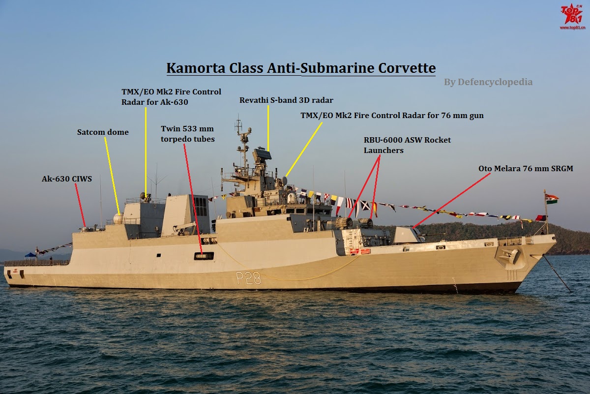
India Rolls its own ASW Corvettes

Kamorta Class : Analysis of India’s Deadly Anti-Submarine Corvette
| Defencyclopedia
Boost for Indian Navy's firepower: INS Kadmatt, anti-submarine warfare corvette, commissioned - The Economic Times
NEW DELHI: Adding to Indian Navy's firepower, INS Kadmatt, the second ship of Project 28 (P28) class anti-submarine warfare (ASW) corvettes, was commissioned on Thursday. With the changing power dynamics in the Indian Ocean Region, INS Kadmatt will augment the mobility, reach and flexibility of Indian Navy.

"Regarded as a very prestigious acquisition, INS Kadmatt is one of the most potent warships to have been constructed in India," said a Ministry of Defence press release. "The ships ..

NEW DELHI: Adding to Indian Navy's firepower, INS Kadmatt, the second ship of Project 28 (P28) class anti-submarine warfare (ASW) corvettes, was commissioned on Thursday. With the changing power dynamics in the Indian Ocean Region, INS Kadmatt will augment the mobility, reach and flexibility of Indian Navy.

Kamorta Class ASW Corvettes - Naval Technology
The Kamorta Class corvettes will serve as the frontline warships for the Indian Navy. Primary task of the Kamorta Class will be ASW, while the vessels will also be deployed in anti-surface warfare (AsuW) and anti-air warfare (AAW).
The Indian Navy placed an order for the construction of four indigenous corvettes in 2003. The keel for the lead corvette in class, INS Kamorta, was laid down in November 2006. It was launched in April 2010 and scheduled to be commissioned into the Indian Navy in 2014. Kamorta experienced engine and steering gear malfunction during trails in October 2013.


Related/Background:

Saturday, January 9, 2016

Apple Spends Mountain of Cash for New Tech for Navigation, Map and User Interface

5 Companies Apple Could Buy Outright (AAPL)
Apple's Acquisitions Tripled in Fiscal 2013 - Businessweek
Apple's $200B war chest ramps up acquisition talk

Sitting on $200 billion in cash and eager to fill gaps in its product line, Apple (AAPL) may find it irresistible not to snap up a company or two, say analysts, mindful of Apple's war chest and growing concerns that iPhone growth could taper next year. Those concerns have helped drive Apple's stock down nearly 6% this month.
There are plenty of candidates, says Daniel Ives, an analyst at FBR Capital. He foresees a "Christmas M&A list" that includes GoPro, Box, Adobe and Tesla Motors.


Some recent acquisitions:

Maps and Navigation

  • Precise Navigation Apple Acquires GPS Startup Coherent Navigation The Coherent Navigation service uses the Iridium satellite network, making the company's acquisition an intriguing technology for Apple. Apple reportedly acquired Coherent Navigation, a Silicon Valley startup that has been using the Iridium satellite network to develop a commercial, high-precision navigation service for a wide range of industries. Apple confirmed the acquisition, according to a May 17 article in The New York Times, but as is the tech giant's custom, the company did not comment further on the purchase beyond saying that it "buys smaller technology companies from time to time, and we generally do not discuss our purpose or plan."- Rationale For Apple's Coherent Navigation Acquisition Extends Beyond Just Maps - Forbes  The higher-accuracy GPS data provided by Coherent’s technology could potentially aid the navigation feature on Apple Maps, particularly in areas with a higher road density or on complicated routes. The technology could also be valuable for Apple’s new and rumored products. For instance, the Apple Watch – which utilizes GPS data from the iPhone for its fitness tracking capacities – could benefit from more precise location data to estimate the distance moved by a user more accurately. Apple is also reportedly very interested in the automotive space, with rumors of an Apple-branded electric car making the rounds (related: Thoughts On An Apple Car). These advanced GPS technologies might prove useful for potential projects such as self-driving cars or related automotive systems. 
  • Mapping Visualization - In September 2015, Apple reportedly acquired Mapsense, a mapping visualization startup, for $25 million to $30 million to bolster its mapping assets as it continues to develop better map tools in iOS 9 and other Apple products, according to another eWEEK report. Mapsense works to help customers create data-driven maps for a wide range of business uses, while also offering mapping visualization tools and services to developers and enterprises. Apple has been struggling with mobile mapping services in the last several years, especially compared with Google Maps and its offerings.

User Interface

  • Facial Analysis - Apple Acquires Emotient Artificial-Intelligence Startup Emotient's technology analyzes facial expressions to detect people's emotions and sentiments to help companies understand their customers. Apple has acquired emotion-detection startup Emotient as the company continues to invest in businesses in a wide range of niches to add to Apple's features and technologies. The Emotient purchase, which Apple made quietly without announcing its terms or sale price, was reported Jan. 7 in The Wall Street Journal. Emotient provides data about customer attention, engagement and sentiment by analyzing a user's facial expressions and detecting their feelings with its cloud-based services, according to the company's Website. "The company is at the vanguard of a new wave of emotion analysis that will lead to a quantum leap in customer understanding and emotion-aware computing," the site states.
  • Facial Expression - In November 2015, Apple confirmed that it had acquired motion-capture technology startup Faceshift, which builds applications that capture human facial expressions as animated avatars or characters. Faceshift's motion-capturing technology has been used in the making of earlier Star Wars movies. In addition, Faceshift has also worked with Intel and Pepsi on previous marketing campaigns that used the company's motion-capture technology.
  • AI for Photos - In October 2015, Apple bought Perceptio, an artificial intelligence startup that works on ideas that could be integrated into future iPhones. Perceptio's technology helps smartphone owners more easily organize and store photos on their iPhones, making them easier to find and use. The price of the acquisition and terms of the deal were not announced. 

Related/Background: