Monday, November 3, 2014

WatchStander with Broadband 4G™ Maritime Radar for Anti-Piracy

WatchStander - An introduction to new technological developments which can spell the end of piracy on the high seas and restore normal freedom of passage though pirate-infested waters.
The automated radar contact tracking, threat assessment, and measured response software that operates WatchStander is a commercial-grade adaptation of proven, mature technologies developed by the Applied Research Laboratory (ARL) at The Pennsylvania State University. The original technologies were developed over the past decade under sponsorship of the US Navy, and much is protected by a patent licensed exclusively to WatchStander.

How It Works

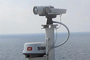
Broadband 4G™ Radar - SIMRAD | Simrad Professional Series
Broadband 4G™ Radar has an impressive 50% improvement in range and target detection capability, with a new 36nm range and 18 range scales to accomodate the increased performance.
  • Beam Sharpening with Target Separation Control
  • Long Range performance
  • Dual range anywhere from 200' to 36nm
  • Up to 48rpm at less than 1nm
  • Directional Clutter rejection and Sidelobe suppression
  • FMCW technology with inherent LPI
  • Extremely low emissions
  • InstantOn™
Simrad Broadband 4G™ is the first dome radar to employ Beam Sharpening. This technology enables a new feature called Target Separation Control, which improves the Azimuth resolution, or effective antenna horizontal beam width, up to double the resolution of any 18-inch dome radar. This is the equivalent of a three and a half foot open array radar.

Improved Range Performance with Noise Rejection Control

Broadband 4G™ Radar uses advanced levels of Digital Signal Processing to reduce the amount of noise picked up by the radome's surroundings. Users can choose the levels of Noise Rejection via an onscreen menu and decide between LOW or HIGH rejection to customise their views (displays without Noise Rejection Control automatically default to High, in this case Target Separation will also be High). Noise Rejection Control increases the Broadband 4G Radar range by up to 50% and also increases target detection sensitivity.
Panbo: The Marine Electronics Hub: Simrad Broadband Radar 4G, hand's-on #1
4G truly is a significant upgrade from the original BR24 and its 3G successor. It does have more power, better range, and better horizontal resolution. Higher possible automated rotation speed will no doubt improve close-in tracking of fast targets (I only got one lobster boat to test that theory on), and the new dual range feature -- if you have an MFD that supports it -- is the absolute bomb. But can it faithfully produce the range of a 4kw radome or the beam width of a 3.5-foot open array? Is it true that "Broadband 4G Radar signals the death of pulse" radar? Sorry, but that kind of talk is premature, I think.
   Not that 4G didn't impress me mightily. Click on that top screen for the highest detail of Camden Inner Harbor, both in range resolution and horizontal resolution, that I've ever seen from a radar antenna 24-inch or less. And note that the radar overlaid over the chart window is operating at a greater range with completely independent controls, something I've never seen before even though the Furuno DRS2D, last discussed here in June, and the Raymarine RD418HD can both do dual range... - See more at: http://www.panbo.com/archives/2011/12/simrad_broadband_radar_4g_hands-on_1.html#sthash.xvmV2elq.dpuf
In my view, 4G truly is a significant upgrade from the original BR24 and its 3G successor. It does have more power, better range, and better horizontal resolution. Higher possible automated rotation speed will no doubt improve close-in tracking of fast targets (I only got one lobster boat to test that theory on), and the new dual range feature -- if you have an MFD that supports it -- is the absolute bomb. But can it faithfully produce the range of a 4kw radome or the beam width of a 3.5-foot open array? Is it true that "Broadband 4G Radar signals the death of pulse" radar? Sorry, but that kind of talk is premature, I think. - See more at: http://www.panbo.com/archives/2011/12/simrad_broadband_radar_4g_hands-on_1.html#sthash.xvmV2elq.dpuf


In my view, 4G truly is a significant upgrade from the original BR24 and its 3G successor. It does have more power, better range, and better horizontal resolution. Higher possible automated rotation speed will no doubt improve close-in tracking of fast targets (I only got one lobster boat to test that theory on), and the new dual range feature -- if you have an MFD that supports it -- is the absolute bomb.

But can it faithfully produce the range of a 4kw radome or the beam width of a 3.5-foot open array? Is it true that "Broadband 4G Radar signals the death of pulse" radar? Sorry, but that kind of talk is premature, I think. Not that 4G didn't impress me mightily.

Click on that top screen for the highest detail of Camden Inner Harbor, both in range resolution and horizontal resolution, that I've ever seen from a radar antenna 24-inch or less. And note that the radar overlaid over the chart window is operating at a greater range with completely independent controls, something I've never seen before even though the Furuno DRS2D, last discussed here in June, and the Raymarine RD418HD can both do dual range -
- See more at: http://www.panbo.com/archives/2011/12/simrad_broadband_radar_4g_hands-on_1.html#sthash.xvmV2elq.dpuf

4G truly is a significant upgrade from the original BR24 and its 3G successor. It does have more power, better range, and better horizontal resolution. Higher possible automated rotation speed will no doubt improve close-in tracking of fast targets (I only got one lobster boat to test that theory on), and the new dual range feature -- if you have an MFD that supports it -- is the absolute bomb. But can it faithfully produce the range of a 4kw radome or the beam width of a 3.5-foot open array? Is it true that "Broadband 4G Radar signals the death of pulse" radar? Sorry, but that kind of talk is premature, I think.
   Not that 4G didn't impress me mightily. Click on that top screen for the highest detail of Camden Inner Harbor, both in range resolution and horizontal resolution, that I've ever seen from a radar antenna 24-inch or less. And note that the radar overlaid over the chart window is operating at a greater range with completely independent controls, something I've never seen before even though the Furuno DRS2D, last discussed here in June, and the Raymarine RD418HD can both do dual range... - See more at: http://www.panbo.com/archives/2011/12/simrad_broadband_radar_4g_hands-on_1.html#sthash.xvmV2elq.dpuf
Radar: Is 4G Better? | boats.com Blog
It only took a couple of seasons for Navico (the parent company of Lowrance and Simrad, among others) to tackle this challenge head-on, and as they developed the NSE and NSO systems they rolled out the Broadband 3G. Transmission power was doubled, and this delivered 30-percent more range and better long-distance target detection. At the same time, 3G still transmits a mere fraction of the energy of a cell phone, and fits into a compact 18” dome.
Yet 32 miles of range remains a bit on the wimpy side, for some large boat owners. Remember: the most important factor in radar range is actually the height of the antenna, because of the curvature of the Earth. If you have a 20- to 30-something center console, cruiser, or express, chances are your radar won’t live up to its full potential no matter how weak or powerful it may be. (Learn more about radar range here). But if you have a 50’ convertible and the radar is 25’ off the water at the top of a tuna tower, a 32 mile unit doesn’t quite cut it.
Now, behold 4G—Navico has introduced yet another version of Broadband barely a year after 3G hit the market, and this one can peek out an additional four nautical miles into the distance with a 36 NM range. The trick lies in reducing the amount of “noise” the radar registers via advanced digital signal processing, 4G can see farther than any Broadband created to date. And there’s one more nifty perk: this system allows you to look at multiple ranges on split-screens, at the same time.

Previous analysis of BR24 Performance

This analysis showed the BR24 Wideband performance for small boats without reflector was 0.5 to 1.5 NM, compared to the IMO requirement of 3.4 NM. The small antenna width resulted in large horizontal beamwidth.

Kazimierski, W.; Lubczonek, J., "Analysis of broadband radar picture in the aspect of marine target tracking," Radar Symposium (IRS), 2011 Proceedings International , vol., no., pp.603,608, 7-9 Sept. 2011 - URL: http://ieeexplore.ieee.org/stamp/stamp.jsp?tp=&arnumber=6041620&isnumber=6041611
Abstract: Broadband radars, known also as a FMCW radars (Frequency Modulated Continuous Wave) is a more and more popular alternative for the pulse radars at sea. The technology is usually used on small boats and yachts (small antennas) or in VTS systems (large antennas). In case of boat the antennas are part of multifunctional navigation systems and in case of VTS they are a part of radar monitoring system chain integrated in VTS centre. In both situations tracking of targets is enabled for the user and is provided by software manufacturer. Particularly interested from the tracking point of view are the systems provided for boats, which has very small scanners (ab. 0,6 m), which means horizontal beam width of 5,2°. The research presented in the article are to show if such a radar can be used for verification of different tracking algorithms as a source of input data for tracking filter. The idea is to examine broadband radar picture in the aspect of target detection and recognition, as these are the key issues in tracking in marine radars.

BR24 Detection Performance vs IMO X Band Requirements
Conclusions: The paper presented the analysis of broadband radar for the needs of radar target tracking. First the theoretical frame was established and then the research with real radar pictures were taken. To sum up the theoretical part it can be said that there are a few factors derived from radar parameters that are of the major meaning if radar picture is good enough for tracking. These are detection and extraction possibilities, discrimination and measurement accuracy.

The problems with detecting of small targets and on the long ranges for the broadband radar has been noticed. In general however it was stated that theoretically FMCW radar should provide picture useful for tracking. There are of course some issues regarding the size of antenna. If it is small bearing discrimination is poor, and it is getting much worse for longer ranges. A little better range accuracy should be expected on the contrary.

The experimental research confirmed theoretical analysis results. The radar pictures of an island with mooring dolphins near it have been analyzed. Broadband radar dolphins are very wide due to huge horizontal beam width. They are not separated from the Island and they are quite close to each other. Pulse radar dolphins are on the other hand longer, because of the pulse technology.

Sunday, November 2, 2014

Fusion of Lidar, Sonar and Photogrametry in GIS updates what lies beneath Pearl Harbor (3D Mapping of USS ARIZONA & USS UTAH)

Mapping History (3D Mapping of USS ARIZONA & USS UTAH - YouTube

Autodesk - National Park Service and Autodesk Carry Out First Comprehensive Digital Survey to Preserve the USS Arizona and Memorial
“This technological approach helps make the USS Arizona’s legacy come alive that just wasn’t possible before,” said National Park Service Superintendent Paul DePrey. “The USS Arizona is one of America’s most revered historical sites. As its steward, the National Park Service has a mission to share the story of December 7 with current and future generations. Creating 3D models allows people to see and touch these highly detailed and accurate replicas, something that will play an important role in our educational outreach program.”
Also present at the press conference was 92-year-old USS Arizona survivor Don Stratton, one of only nine remaining USS Arizona survivors still alive, and one of only a few hundred to make it off the ship. Stratton was only 19 years old when Pearl Harbor was attacked. He along with six other crew members went hand over hand on a heaving line across the burning deck to safety on the USS Vestal that was moored alongside the USS Arizona that fateful morning. Stratton suffered burns over 70 percent of his body.
When presented with the 3D print of the cooking pot for the first time, Stratton said, “That is amazing. I don’t know anybody in the galley that survived that day. At the time of the explosion, it was self-preservation. After that, it was extremely hard to return. Now, when I go back and remember, it’s a little easier. I think it [3D artifacts] will make an impression on a lot of people, I really do.”
Stratton’s son Randy Stratton, who was also present, said, “You can’t duplicate these artifacts. They represent the beginning of the war, the end of the war and the fact that there is still life there [on the USS Arizona].”
Don Stratton concluded, “I hope they remember all the shipmates that are still aboard the Arizona. And I hope they remember all the people that gave their lives for this great country.”
Dive into This Digital USS Arizona in the Name of Conservation
Future Technology Brings History to Life Today in Pearl Harbor
 All Hands Online : Teams conduct 3D survey of USS Arizona and USS Utah
Between the Lines: Technology Teams Conduct 3D Survey of USS Arizona and USS Utah
Sensors used:
A team of U.S. Navy and supporting company operators and photographers carried out underwater dives  documenting the photogrammetry technique used underwater in Pearl Harbor Hawaii last week.
Below is a quick video of the vie capturing photos of the USS Arizona and USS Utah as well as Shaan Hurley of Autodesk explaining how we at Autodesk were using photogrammetry using Autodesk ReCap Photo and 3D Printing as well as SONAR and LiDAR technologies to capture the iconic ships in 3D to use in education, preservation, and research.


Diving in History: Pearl Harbor Memorials from Brett Patrick Cote on Vimeo.

Studied 30 years ago

Technology has changed a lot since the last survey.
Submerged Cultural Resources Study: USS Arizona Memorial and Pearl Harbor National Historic Landmark : Lenihan, Daniel : Free Download & Streaming : Internet Archive


Southwest Cultural Resources Center Professional Papers No. 23 Santa Fe, New Mexico 1989


At a time when more and more flashy, high-tech discoveries and salvage of long- lost undersea wrecks occur, this submerged cultural resource study of the Arizona Memorial is a refreshing change. The combined experience of the National Park Service's Submerged Cultural Resources Unit and the Navy's Mobile Diving and Salvage Unit One is remarkable, they are as expert at their business as can be found. What stands out, though, is that these talented divers sought and brought back for us all not artifacts, not souvenirs, not booty - simply knowledge. After the years of meticulous studies, foot-by-foot inspection and recording -- the USS ARIZONA and its sister ships all still rest secure, exactly as they were before this energetic endeavor began. You, too, can rest assured that these historic undersea relics will remain unimpaired. This is a classic study of how under- sea explorations ought to be done so as to leave their historic subjects intact. In this publication, you have a thoughtful sum- mary of the knowledge they gleaned.

Bryan Harry Pacific Area Director National Park Service
 

Boeing’s X-37B - traces roots to X-20 Dyna Soar

Boeing’s X-37B - Son of X-20 Dyna Soar

Wondering What the U.S. Air Force’s Secretive Spaceplane Can Do? History Offers Clues — War Is Boring — Medium
the X-37B is not the first design of its type. Boeing’s X-20 Dyna Soar proposal, now more than 50 years old, offers some clues as to what today’s X-37B could do.

X-20 Dyna-Soar


X-20 Dyna-Soar Spaceplace Was Decades Ahead of Its Time | Defense Media Network
Dyna-Soar is often compared to the space shuttle, which began flying on April 12, 1981 and completed its 135th and last orbital journey on July 21 of this year. The shuttle was too large and complex to offer cost-effective orbital capabilities for other than the costliest and most complex missions. But Dyna-Soar was also a progenitor and closer relative of the X-37B, the reusable robot spaceplane that was transferred from NASA to the Department of Defense in 2004.
Two X-37Bs have been boosted into low earth orbit from Vandenberg Air Force Base, Calif., by Atlas V 501 rockets, the second on May 5 of this year. The Air Force has said very little about the mission of the X-37B. Officials insist it is a research craft only and it is labeled a “test” vehicle, but space-watchers wonder if it has reconnaissance duties. Except for the absence of a human pilot on board, the X-37B could be a Dyna-Soar on steroids.

X-37B

Air Force's Mysterious X-37B Space Plane Passes 400 Days in Orbit
The U.S. Air Force's unmanned X-37B space plane has now circled Earth for more than 400 days on a hush-hush mission that is creeping closer and closer to the vehicle's orbital longevity record.
The X-37B spacecraft launched on Dec. 11, 2012, meaning that it has been aloft for 413 days as of Tuesday (Jan. 28) on the third mission for the program, which is known as OTV-3 (short for Orbital Test Vehicle-3). The endurance record is 469 days, set during OTV-2, which blasted off in 2011.
OTV-2 and OTV-3 have utilized different X-37B vehicle (the Air Force currently has two vehicles). The space plane currently zipping around Earth also flew the program's inaugural OTV-1 mission, which stayed in space for 225 days after launching in 2010. [See photos from the X-37B space plane's OTV-3 mission]
Space architecture is the weak link in US defense policy | TheHill
On Oct. 17, the Air Force's mysterious X-37B reusable unmanned spacecraft landed at Vandenberg Air Force Base after almost two years in orbit. The X-37 is arguably the pinnacle of the United States' space technology, demonstrating the key metric of reusability that will help to ensure lowered costs and increased capabilities for years to come. It will operate on a frontier that will only become more crucial with increased technology and a battlefield that utilizes the space above our atmosphere. It also represents the seriously flawed logic of current U.S. space infrastructure that could spell tragedy rather than victory if any symmetric threats are faced by our military in the near future.


International Reaction

X-37B Orbital Test Vehicle’s mission is Pentagon’s closely guarded secret
Officially, the only role the Pentagon acknowledges is that the space plane is used to conduct experiments on new technologies. Theories about its mission have ranged from an orbiting space bomber to an anti-satellite weapon.
The truth, however, is likely much more obvious: According to intelligence experts and satellite watchers who have closely monitored its orbit, the X-37B is being used to carry secret satellites and classified sensors into space — a little-known role once played by NASA’s new retired space shuttle.
For a decade between the 1980s and early 1990s, NASA’s space shuttle was used for classified military missions, which involved ferrying military payloads into space. But the shuttle’s military role rested on an uneasy alliance between NASA and the Pentagon. Even before the 1986 Challenger disaster, which killed all seven crew members, the Pentagon had grown frustrated with NASA’s delays.

En quatre mots: un drone militaire dans l'espace
When NASA abandoned project X-37 in 1999, after determining that it would be too expensive for use as a taxi to the International Space Station, the Air Force jumped at the chance to take it over. "NASA had only a reduced model, the X-37A, to go into space. The Air Force built the X-37B space and working on a version of the X-37C, which in my opinion will never see the day because it would be too expensive. The Air Force dream of a space fighter since the 50s, "says Jonathan McDowell. He first proposed the Boeing X-20 Dyna-Soar, a military space shuttle program was canceled in 1963. Then the manned orbiting laboratory, which was for espionage and was canceled in 1969 when realized that spy satellites would be cheaper. The Air Force Space Command was created in 1982 along with the space engineering battalion whose members had a few missions on the space shuttle before the battalion was dissolved in 1990.
Secret space unmanned vehicle X-37B housed at Kennedy Space Center
Experts from Russia agree with the opinion that the unmanned spaceship is a combat drone. Head of the Space Policy Institute Ivan Moiseev, believes that it is a purely military unit, and its mission the Americans kept secret. There is unusual secrecy about the project, confirmed Alexander Zheleznyakov, Academician of the Tsiolkovsky State Museum of Cosmonautics in an interview with "Russian world". It is unlikely that the device will be used to attack targets on the surface of the Earth, but it could well lead to a successful project space interceptors, which will be able to stop and inspect objects on the Earth's orbit, and if necessary, destroy them. This mission caused Alexander Shirokorad of "Independent Military Review", to call the unit "a reusable aerospace pirate." However, Ivan Moiseyev states the X-37B - is still not ship Interceptor, but a "mother ship for small satellites." He believes that in the case of a local conflict, the unmanned spaceship will be able to bring to orbit a number of small satellites that will provide the necessary military data, information and communication. At the moment, this device has been up to orbit three times - in 2010, 2011 and 2012. And each flight spacecraft was longer than the last. And the X-37B, which was launched in 2012, is still in Earth orbit. Details of each of these missions were not disclosed. However, during the second flight in the press slipped information that the device is working on gathering intelligence information. , сообщает http://www.riasv.ru

Saturday, November 1, 2014

Fish or Cut Bait time for F-35C

F-35 Ahoy! Navy Version Of JSF Faces Nimitz’s Tests « Breaking Defense - Defense industry news, analysis and commentary

WASHINGTON: The next two weeks will be enormously important for the Navy’s carrier-based version of the Joint Strike Fighter as two F-35Cs undergo extensive testing operating from the USS Nimitz. The Navy has been the least committed of the three services buying versions of the Joint Strike Fighter, so if the two planes being tested perform well it could help change the views of some senior Navy leaders. Anything less
than a sterling performance, of course, could well give reluctant Navy officials more ammunition to buy more F-18s and stretch out or shrink their planned purchase of F-35Cs. Lt. Gen. Chris Bogdan was very upbeat about the aircraft during a program briefing with reporters yesterday. The two F-35Cs are flying directly to the carrier and will land using arresting gear, he said. No cranes gently lifting the planes onto the
Nimitz’s deck. Nope. These aircraft will fly the last portion of their trip and are expected to execute the carrier version’s very first landing on a carrier with a small group of reporters watching. 
F-35C's First Carrier Landing Scheduled for Next Week - USNI News
The naval variant of the tri-service Lockheed Martin F-35 Lighting II Joint Strike Fighter is set to land upon the deck of USS Nimitz (CVN-68) next week. Two of the single-engine F-35C stealth fighters are set to carry out a set of sea trials onboard the carrier to ensure that the jets can operate safely from the flight deck.
Navy F-35 starts first sea trials with new tailhook | Military Times | militarytimes.com

F-35C Joint Strike Fighter makes first landing at NAS Oceana | WTKR.com

previously:

spendergast: Navy's F-35C Tailhook apparently fixed

Ariane 5 lifts 2 Satellites at once - INTELSAT 30 (IS-30) and ARSAT 1 to GEO Orbit

Payload
DLR Portal - Ariane - Europe's access to space
Launch Notification: INTELSAT 30 (IS-30), ARSAT 1

"An Ariane 5 launcher fired into space Thursday from French Guiana, hauling two commercial satellites destined to broadcast television to Latin America for Intelsat, DirecTV and Argentina's national telecom company.


Intelsat 30 Official Launch Site | Intelsat S.A.


Intelsat 30, 31 / DLA 1, 2 (ISDLA 1, 2) - Gunter's Space Page

Space Systems/Loral (SS/L) announced in September 2011 that it has been awarded a contract to provide two high-power hybrid C- and Ku-band satellites, called Intelsat 30 and 31 or DLA 1 and 2, to Intelsat for Direct-to-Home (DTH) television service in Latin
America. The two satellites will be operated by Intelsat, which will provide the complete Ku-band capacity of them to DIRECTV Latin America, a DTH digital television services operator in Latin America.

Analyst: Latin America makes DirecTV especial
— Tech News and Analysis
The Ku-band payloads, refered to as DLA 1 and 2, will be used to expand DTH entertainment offerings and provide backup and restoration services. The two satellites are scheduled for launch in 2014 and 2015, respectively, and will be co-located with  Intelsat’s Galaxy 3C satellite at 95°W, which DTVLA has used since 2002.
DIRECTV Galaxy 3C - 95W Coverage
Each satellite will feature 10 C-band transponders for Intelsat’s own use for expanding its business in the growing Latin American market.

The two satellites are designed based on the decades proven Space Systems/Loral 1300 platform and the first is scheduled to launch in 2014. They are contracted to provide service for a minimum of 15 years.

Argentina launches its first home-built satellite
ArSat-1: Argentina to communicate its heightened space ambitions | NASASpaceFlight.com
The ARSAT-1 satellite is the first to be constructed with local technology in Latin America. It was built by a crew of about 500 scientists over seven years at a cost of $250 million. The satellite was launched from a base in French Guiana and is to orbit 22,000 miles (36,000 kilometers) above Earth.


"ARSAT-1 is on its way to space. What a thrill," President Cristina Fernandez said shortly after the launch via her Twitter account. Cristina Fernandez de Kirchner - Twitter


ARSAT-1 is designed to provide digital television and cellphone services to Argentina, Chile, Paraguay and Uruguay for the next 15 years. It's also expected to improve telephone and Internet connections in remote places, including for scientists working in the Antarctic region.