Health Care Systems Oncology, Imaging and Pharmacology, particularly for Prostate Cancer.
Technology that interests me: Sensors (Radar, Sonar, EO/IR,Fusion) Communications, Satellites, Unmanned Vehicles (UAV), Information Technology, Intelligent Transportation
The
Aviationist » This Infographic Provides Lots of Details about Russia’s
S-400 Advanced Air Defense Systems allegedly deployed to Syria
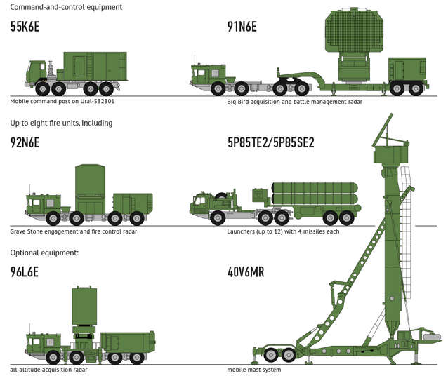
Designated SA-21 “Growler” by NATO, the S-400 is believed to be able
to engage all types of aerial targets including aircraft (someone says
even VLO – Very Low Observable ones), drones and ballistic and cruise
missiles within the range of 250 miles at an altitude of nearly 19
miles. Equipped with 3 different types of missiles and an acquisition
radar capable of tracking up to 300 targets within the range of over 370
miles, the Triumph (or Triumf) is a system made of 8 launchers and a
control station.
96L6 / 96L6E Radar
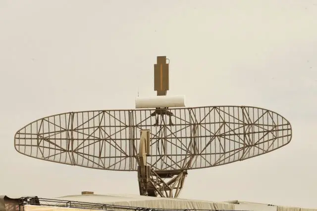
The Lianozovo Electromechanical Plant and the Lira KB design bureau displayed a model of their 96L6 radar vehicle
at the IDEX '97 exhibition. The phased-array centrimetric system is
mounted on a MAZ-7930 (8x8) truck chassis and is intended for use with
the S-300PMU and S-300PMU1 air defence systems as an upgrade to replace
several existing radar's with a single more capable system. The 96L6 can
function as a low-altitude detection set surveillance radar and as a
battery command post. The maximum detection range is 300 km and it can
track up to 100 targets simultaneously at speeds between 30 to 2,750
m/s. If required, the radar antenna assembly can be fitted to a 40V6M
tower unit for better low-altitude coverage. The 96L3 is considered an
all-weather all-altitude radar system.
The 96L6E all-altitude radar is designed for detecting,
determining the state nationality, identification of classes, locking-on
and tracking the routes of air targets, outputting target designation
and three-coordinate information about all detected air targets to the
users over the radio channel
and/or fiber-optics communication link. The procedure of radar data
transmitting to the user is specified by coordinated interface protocol,
and under hardware control by the method of replacement of reprogrammed
interface cards.
Specifications
Wavelength
Centimetric
range, km
300
azimuth, degrees
360
elevation, degrees
-3 up to +60
speed, m/s
30-2800
Targets
Up to 100
update time, sec:
- In the bottom zone
6
- In average and top zones
12
Setup Time from march,
5 minutes
Supported by effective EW (Electronic Warfare) capabilities, the
S-400 fires missiles that fly at 17,000 km/h against aerial targets: at
least on paper, all non-stealth planes (including 4+ Generation planes)
will hardly be able to dodge them.
This means that all but U.S. F-22s and B-2s would be threatened by such an advanced air defense system over Syria (and in nearby airspaces).
The S-400 is capable of hitting targets at a height of up to 300 kilometers (186 miles). Its second distinctive feature is fire-and-forget capability. Its missiles are fitted with a homing device which can lock on a target and destroy it. Unlike US systems, it is said that the S-400 does not need to track the target. In addition, the S-400 is the only missile complex in the world capable of hitting targets located beyond the horizon. The system is also well protected against electronic warfare.
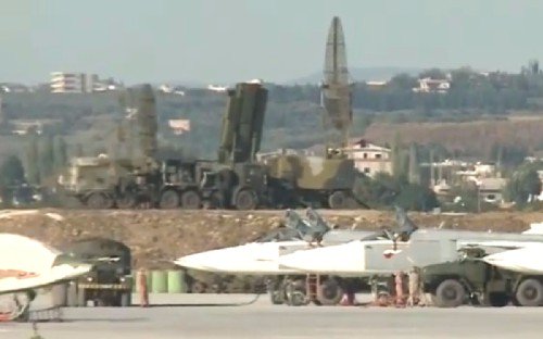
Syria Deployment
Anti-aircraft missile system S-400 "Triumph" that Russia has decided to transfer to Syria after the shoot-down of the bomber Su-24M, will not only ensure the protection of the Russian aircraft throughout the Middle Eastern country, but also can be tested in combat conditions. Such an
opinion was expressed by 25 November 2015 TASS interview with military experts. After the operation in Syria S-400 will be returned to Russia.
The plans place the newest system S-400 on the Syrian Hmeymim airbase, where Russian aircraft stationed, said November 25 Russian Defense Minister Sergei Shoigu. As explained later, Assistant to the President for Military-Technical Cooperation, Vladimir Kozhin, leave the newest systems in Syria is not planned - they are transported back to Russia after the operation against terrorists.
The decision to transfer the S-400 to the Middle East was a reaction to the loss of the Su-24M, which was shot down on the eve of the Turkish F-16 fighter. Turkey said that the downed aircraft violated the airspace of the country, while the Defense Ministry insisted on the opposite - a Turkish fighter plane intruded into the sky over Syria and Russian bomber did not break any boundaries.
On Thursday, Nov. 26, China conducted another surprise launch this year, lifting the Yaogan-29 satellite into space. The spacecraft was launched atop a Long March 4C booster at 4:24 p.m. EST (21:24 GMT) from the LC9 launch complex at the Taiyuan Satellite Launch Center (TSLC), located in Shanxi Province, north China. As was the case with many previous Chinese missions this year, Thursday’s launch was performed without any prior notice from the country’s officials. The mission was declared a success by the Chinese media outlets after the satellite was successfully delivered into its target Sun-synchronous orbit (SSO) at an altitude of 382 miles (615 km), inclined 97.8 degrees. Debris from the rocket fell in Hubei province in central China. No damage or injuries were reported.
According to Chinese sources, the Yaogan-29 remote sensing satellite was developed by the Shanghai Academy of Spaceflight Technology (SAST) and has a spatial resolution of 1.64 feet (0.5 meters), though the instrument is not known. The spacecraft weighs around three metric tons.
It is reported that Yaogan-29 features an electronic motor-powered solar panel which expands under the command from the ground control station.
The state-run Xinhua press agency insiststhat the satellite will be used for experiments, land surveys, crop yield estimates, and disaster relief. However, Western analysts and observers believe that the Yaogan satellites are of a military nature. They could use electronic intelligence (ELINT), electro-optical, and synthetic aperture radar (SAR) sensing equipment for military purposes. The Yaogan system, composed of optical imaging and radar satellites, could be conducting reconnaissance on a global scale. It was inaugurated in April 2006 when the first SAR satellite was sent into space.
Washington, D.C. – An anonymous whistleblower within the U.S.intelligence community provided a cache of classified intelligence documents to The Intercept, which revealed the extremely dysfunctional nature of the American drone warfare/targeted assassination program. The eight-part investigation, which included documents, analysis, slides, and visuals, was released on Thursday as “The Drone Papers,” by The Intercept. The stunning array of classified information revealed an extreme lack of precision in the drone assassination campaign, with one document reporting that “nearly 90 percent of people killed in airstrikes were not the intended targets” over one five-month period.
The Intercept’s ‘Drone Papers’ Revelations Mandate a Congressional Investigation | Foreign Policy
This morning, the reporting team at the Intercept published an impressive eight-part series on the policies and processes of U.S. drone strikes, called “The Drone Papers.” Some of the newly reported information is purportedly
based upon “a cache of secret slides that provides a window into the
inner workings of the U.S. military’s kill/capture operations … between
2011 and 2013.” Intercept journalist Jeremy Scahill writes that
the slides “were provided by a source within the intelligence
community.” (Full disclosure: I spoke with two reporters from the Intercept about some of these documents in mid-July and have a partial quote in one of the pieces.)
The Intercept's "Drone Papers" Won't Do Much for Transparency | The National Interest
In the short term, the Drone Papers renew questions about many of the
administration’s claims surrounding the lethal drone program and may
help reignite calls for greater transparency and increased oversight.
But it is unlikely that the documents will result in any considerable
changes in the ways in which U.S. drone operations are conducted or the
extent to which U.S. policy on drones is disclosed. This reality is
particularly likely for two key reasons: general public support for the
drone program and lack of Congressional and administrative action
towards greater transparency and accountability.
The 'Drone Papers' Do Not Reflect All Drone Programs, Especially in Pakistan | C. Christine Fair
Recently, The Intercept announced that it had
"obtained a cache of secret documents detailing the inner workings of
the U.S. military's assassination program in Afghanistan, Yemen and
Somalia." According to The Intercept, the documents, which were
illegally furnished to the news outlet by a so-called whistleblower,
"offer an unprecedented glimpse into Obama's drone wars."
Despite the hype, the documents offer little that is new. In fact, major newspapers, such as the New York Times, Washington Post, Financial Times and Los Angeles Times,
did not bother reporting on it. Worse, members of The Intercept team
continue to obfuscate the complex issues surrounding the various U.S.
drone programs and these documents to promote what appears to be an
anti-drone agenda.
The "Drone Papers" suffer from "selection
bias." Selection bias occurs when the information that is available (the
"sample") is not representative of all information about a particular
subject ("the universe"). We would all recognize such bias if a polling
firm claimed to offer insights into the "American voter" but only
interviewed white males between the ages of 18 and 30. We would
immediately understand that the survey could only speak to a particular
slice of the American public.
First, a brief word about the nature of Mr. Greenwald’s enterprise, The Intercept. The Intercept has set up a secure drop box to facilitate government employees’ illegally providing classified information to the organization. Mr. Greenwald and his associates refer to these persons as “whistleblowers.” And let's leave aside for a moment whether that's a fair description. Empirically, the documents that have
been leaked are riven with selection bias; leakers, driven by whatever personal motives, often selectively leak specific documents.
Making a Bad Sausage out of Bad Data
In addition to the classified materials The Intercept has garnered, let’s turn to the ways in which Mr. Greenwald utilized these documents in the Al Jazeera debate. The discussion began with Mr. Greenwald making the sweeping assertion that 90 percent of the drone victims are “innocent.” Mr. Greenwald buttressed this claim by citing documents provided by the “whistleblower,” whose leaked materials formed the basis of "The Drone Papers." Obviously, someone who is breaking the law to provide these documents must be presumed to be completely honest and factually correct in his
assessments.
There are several problems with this assertion. First, The Intercept claims that the documents it received “show that during a five-month stretch of the campaign [Operation Haymaker], nearly nine out of 10 people who died in airstrikes were not the Americans’ direct targets.” This is not the same as being “innocent.” Moreover, the documents shown in the report do not demonstrate this claim. In fact, one slide detailing the mission statistics for Task Force 3-10 from September 2011 through September 2012–a longer period of time than the five-month period cited above–indicates that only 14 civilians were killed. However, the leaker asserts that “the 14 civilian casualties is highly suspect … I know the actual number is much higher.” Why should anyone believe this claim?
Using and Abusing Data
During the discussion, Mr. Greenwald and Mr. Hasan made ample reference to a particular advocacy-driven report on drones in Pakistan authored by persons associated with the law school clinics of NYU and Stanford University Law Schools. That report is deeply flawed in every manner of execution. Let's start with the fact, acknowledged by the authors, that the report was commissioned and facilitated by Reprieve. The authors concede that in “December 2011, Reprieve, a charity based in Britain, contacted the Stanford Clinic to ask whether it would be interested in conducting independent investigations into whether, and to what extent drone strikes in Pakistan confirmed to
international law and caused harm and/or injury to civilians” (p. i.).
EDWARDS AIR FORCE BASE, Calif. — An Air Force Research Laboratory-sponsored X-56A unmanned air vehicle crashed on November 19 at approximately 9:30 Pacific Daylight Time on Rogers Dry Lakebed test range at Edwards AFB, California. The mishap occurred shortly after takeoff.
Initial estimates report severe damage to the vehicle. There are no reports of injuries or property damage at this time. Edwards AFB emergency responders were on scene.
An accident investigation team has been established to investigate what occurred, identify lessons learned, and determine how to move forward.
X-56A · Lockheed Martin
The X-56A is an experimental unmanned multi-utility technology testbed designed to demonstrate
active flutter suppression and gust load alleviation in flight. The aircraft previously made 16 successful flights spending approximately six hours in the air.
=================================
File photo:
VIRIN: 150304-F-IW159-012
Some of the technology on display was not solely to NASA's credit. The U.S. Air Force Research Laboratory also worked with NASA on the X-56, a 28-foot wing span unmanned aerial vehicle designed to test active control of flexible structures. (U.S. Air Force photo by Rebecca Amber/Released)
Iran inaugurates new air defense command and control center in Southwestern part of the country The
Iranian Air Defense Force inaugurated a new command and control center
in the Southwestern parts of the country in a ceremony participated by
Lieutenant Commander of Khatam ol-Anbia Air Defense Base Brigadier
General Alireza Sabahifard. Sabahifard told reporters on
Wednesday, November 25, 2015.
Farsnews
Lieutenant Commander of Khatam ol-Anbia Air Defense Base
Brigadier General Alireza Sabahifard
"The
command and control system of the Southwestern zone acts as a part of
the Air Defense Base's integrated command and control network and is
capable of precisely monitoring and defending the Islamic Republic of
Iran's airspace in all dimensions. The
system is a tactical combat system that operates through using tracing
and collecting the active and passive data of hostile equipment and
through cyber operations and electronic warfare."
Iran enjoys a highly powerful and capable integrated air defense system equipped with the state-of-the-art equipment. In
September, Iran unveiled two new home-made radar systems named Nazir
and Bina with the capability of detecting radar-evading targets and
fighting against electronic warfare on the occasion of Air Defense Day. Nazir
is a long-range and high-precision radar system which is highly capable
of detecting targets in low radar cross section and is resistant to
radar evading and anti-radar missiles. The radar can detect all radar-evading targets and is capable of fighting electronic warfare. Bina and Nazir radar systems have been mounted in the mountainous and plain regions in Southeastern Iran. Elaborating
on the specifications of the two radar systems, Commander of Khatam
ol-Anbia Air Defense Base Brigadier General Farzad Esmayeeli said that
they are fully home-made and unique in the region and the world. "The
radars have been designed in different frequencies and with jump
frequency and also in (special) bands which cannot be heard by the
enemies," he added. Esmayeeli
explained about other features of the radar systems, and said they are
multi-range radars, meaning that they can detect wide-body and stealth
targets as well as small planes, including drones, in long distances
before they can approach Iranian borders. He expressed the hope that the two radar systems will be mass-produced within one year.
Information technology is transforming the way physicians practice
medicine, the way health care systems do business, and the way consumers
make decisions about health care. For over a decade, RAND researchers
have been at the forefront of efforts to analyze and evaluate how health
information technology (HIT) can improve patient outcomes, increase
access to care, and reduce spending. Since an influential 2005 study on
the potential benefits of widespread adoption of HIT, RAND has
considered the design of electronic health records (EHRs), examined the
impact of health information exchange (HIE), and reviewed the impact of
HIT in the context of recent federal legislation.
Decades of research has firmly established that telemedicine
expands access to health services for individuals living in remote and rural
areas. Evidence is beginning to accumulate that telemedicine may be “especially appealing” for those “who are
infrequent users of health care and to those who are relatively resistant to
usual outreach methods and vulnerable to untreated chronic conditions in the long
run.” Equally important, development of telemedicine is now intersecting with
rapid and ongoing changes in the health care system’s organizational structure
toward provision of more integrated care models and toward payment protocols
that aim to shift reimbursement toward payment for value. These trends are
accelerating even as different forms of telemedicine are being used in a
complementary fashion; as electronic health records become mainstream;and as
shared electronic record systems are extended to independent practitioners,
community hospitals, and providers of various community-based services
Telehealth
services surging despite questions about value - Modern Healthcare
Modern Healthcare business news, research, data and events
Investors think consumers will find virtual visits—either by phone or
online video connection—more convenient, cheaper and just as effective
as in-person doctor visits, particularly for relatively minor
urgent-care needs. Insurers increasingly are embracing telehealth. In
December, Anthem,
the nation's second-largest insurer, announced that it would begin
offering telehealth visits with no copay to its Medicare Advantage
members in 12 states, including California, Florida and New York.
Advocates
of the virtual-visit model argue that expanding access to telehealth
services would reduce costs by heading off more expensive urgent care
and emergency department care, and that consumers increasingly will
substitute virtual visits for in-person visits so that the total amount
of services will not rise. But critics question that assumption,
cautioning that consumers may use telehealth in addition to traditional
in-person visits, thus boosting total spending. They also worry about
the quality of video and phone visits compared with in-person visits,
and whether virtual care will be coordinated with patients' regular
care.
“This fits into a larger initiative we're seeing of trying
to provide care in a more convenient way,” said Dr. Ateev Mehrotra, an
associate professor of healthcare policy at Harvard Medical School who
studies telehealth.
Analysis Of Teladoc Use Seems To Indicate Expanded Access To Care For Patients Without Prior Connection To A Provider
Despite the potential benefits of telehealth applications, little is
known about their overall impact on care. This is critical
because rising health care costs and a shortage of
primary care providers make it likely that telehealth services will play
an increasingly important role in health care
delivery. To help fill this gap in knowledge, we describe early
experiences
with Teladoc, one of the largest telemedicine
providers in the United States, which provides care directly to patients
over
the telephone or via the Internet. We analyzed
claims data for a large California agency serving public employees that
recently
offered Teladoc as a covered service. The 3,701
Teladoc “visits” we studied were for a broad range of diagnostic
categories,
the most common of which were acute respiratory
conditions, urinary tract infections, and skin problems. Compared to
patients
who visited a physician’s office for a similar
condition, adult Teladoc users were younger and less likely to have used
health
care before the introduction of Teladoc. Patients
who used Teladoc were less likely to have a follow-up visit to any
setting,
compared to those patients who visited a
physician’s office or emergency department. Teladoc appears to be
expanding access
to patients who are not connected to other
providers. Future research should assess the impact of Teladoc and other
telehealth
interventions on the quality and cost of care.
BACKGROUND: Direct-to-consumer (DTC) telemedicine serves millions of patients; however, there is limited research on the care provided. This study compared the quality of care at Teladoc, a
large DTC telemedicine company, with that at physician offices and compared access to care for Teladoc users and nonusers.
MATERIALS AND METHODS: Claims from all enrollees 18–64 years of age in the California Public Employees' Retirement System health maintenance organization between April 2012 and October 2013 were analyzed. We compared the performance of Teladoc and physician offices on applicable Healthcare Effectiveness Data and Information Set measures. Using geographic information system analyses, we compared Teladoc users and nonusers with respect to rural location and available primary care physicians.
RESULTS: Of enrollees offered Teladoc (n = 233,915), 3,043 adults had a total of 4,657 Teladoc visits. For the pharyngitis performance measure (ordering strep test), Teladoc performed worse than
physician offices (3% versus 50%, p < 0.01). For the back pain measure (not ordering imaging), Teladoc and physician offices had similar performance (88% versus 79%, p = 0.20). For the bronchitis measure (not ordering antibiotics), Teladoc performed worse than physician offices (16.7 versus 27.9%, p < 0.01). In adjusted models, Teladoc users were not more likely to be located within a healthcare professional shortage area (odds ratio = 1.12, p = 0.10) or rural location (odds ratio = 1.0, p = 0.10).
CONCLUSIONS: Teladoc providers were less likely to order diagnostic testing and had poorer performance on appropriate antibiotic prescribing for bronchitis. Teladoc users were not preferentially located in underserved communities. Short-term needs include ongoing monitoring of
quality and additional marketing and education to increase telemedicine use among underserved patients.
The top 10 schools by top secret-level security clearances are:
1. University of Maryland 2. American Military University
3. University of Phoenix
4. George Washington University
5. George Mason University
6. Strayer University
7. Cochise University
8. Webster University
9. Johns Hopkins University
10. Troy University
Vice reviewed resumes of more than 90,000 people who have worked in the intelligence community since September 11, 2001 and condensed the list to individuals who had top secret clearance.
For resumes that did not include clearance level, Vice included resumes of people in one of the 17 agencies that comprise the intelligence community.
#1 UNIVERSITY OF MARYLAND College Park, Maryland | Public
As the online division of the U.S. New and World Report’s 62nd best
national university and 20th top public school, the University of
Maryland University College (UMUC) is one of the largest public distance
learning institutions in the world with over 90,000 students. With more
than 95 degree programs delivered through WebTycho from its
headquarters in Adelphi, UMUC has an open admissions policy for its
undergraduate offerings. In the #1 spot for educating military veterans,
UMUC also has been ranked 16th among America’s “Best Buy” online
programs for tuition rate affordability on GetEducated.com.
Undergraduate students at UMUC have their fair share of
security-related majors to choose from in a student-centered online
community. Offered with rigorous 120-credit curricula, UMUC has online
bachelor’s degrees for Computer Networks and Security, Cybersecurity,
Investigative Forensics, and Software Development and Security. Some
aspiring security professionals may also wish to pursue the online
undergraduate major in Public Safety Administration, which is focused on
developing the decision making, teamwork, technology, leadership,
communication, and risk management skills necessary to protect citizens
from harm. Minors in Corporate Security, Emergency Management, Homeland
Security, Cybersecurity, or Terrorism and Critical Infrastructure may be
helpful too.
Both featuring a 36-credit online curriculum, the M.S. in
Cybersecurity and M.S. in Cybersecurity
Policy programs at UMUC are
popular for security professionals wishing to advance their knowledge of
protecting an organization’s cyber assets. An online M.S. in Digital
Forensics and Cyber Investigation is available for mid-career
professionals needing a skills boost to meet new challenges in
uncovering digital evidence. UMUC also provides a Master of Science in
Management (MSM) program fully online from anywhere with
security-related specializations in Criminal Justice Management,
Emergency Management, Homeland Security Management, Intelligence
Management, and National Security.
OVERVIEW
Percent Online: 37%
Top Secret Employment Rank: 1
National Security Funding Rank: 4
DoD Research & Development Funding: $117,491,000
Students on GI Bill/Tuition Assistance: 38%
GOVERNMENT AFFILIATIONS
Conducts Classified Research
National Intelligence
NSA
Homeland Security
FBI
Military ROTC Program
NATIONAL SECURITY CURRICULUM
Intelligence Studies Program
Homeland Security Studies Program
Drone Program
“The ICEYE system is unique because we do not rely on traditional
optical imaging technology. Unlike camera technology, our radar is not
limited by the same requirements – it’s capable of viewing through cloud
cover, bad weather, and darkness, providing unlimited access wherever
it’s needed. The
timeliness of the imaging service is always limited by the speed of
access to the target site. We’ve applied miniaturization and industrial
manufacturing to the field of radar imaging. This allows us to launch
not just one, but tens of satellites and ultimately reduce the response
times from days to minutes. We believe this breakthrough in earth
imaging is going to have a real positive impact on the world." says Iceye CEO/Co-founder Rafal Modrzewski.
Iceye’s first customers are oil and shipping companies that need SAR
to track the movement of ice in the Arctic around the clock in all
weather conditions. Ultimately, the company wants to create an app and
corresponding API that allows anyone to subscribe to a feed of SAR
images of a particular area such as a farm, road, port or property
anywhere in the world. Iceye is a spinout from Aalto University Radio Science & Engineering department. Rafal described how radar imagery can help save
lives:
“Just last week, we were in Greece to help the aid organizations.
They are struggling to rescue the refugees crossing the bay to Lesvos in
their overcrowded boats,” he said. “We brought ground-based radars to
track the vessels, and they were game-changing to the rescue
operation—but their range is limited. The order-to-delivery time for
commercially available satellite imagery is around a week, which doesn’t
help if the boats can capsize and disappear in minutes. That’s why we
are working hard every day to get our own service up and running.”
Army system integrates different radars for Patriot-3 interceptor
The flight test employed an MQM-107 drone target serving as a cruise
missile surrogate. It flew a low-altitude trajectory against an asset
defended by a battery and battalion IBCS engagement operations centers.
Because the low altitude trajectory, the missile was obscured from the
Patriot radar's field of view but the IBCS used the Sentinel composite
tracking data to calculate and present the necessary engagement
solution. The engagement operations center operator then commanded, via
the IBCS mission control software, the launch of a single PAC-3
interceptor missile to destroy the target.
"IBCS replaces seven legacy C2 systems to deliver a single integrated
air picture and offer the flexibility for deployment of smaller force
packages," Northrop Grumman said. "By networking sensors and
interceptors – as opposed to simply linking them – IBCS provides wider
area surveillance and broader protection areas."
The US Army Air and Integrated Missile Defense Program successfully
completed their second test of Northrop Grumman's Integrated Battle
Command System by intercepting a Cruise Missile target using a PAC-3
interceptor and track data from Sentinel and Patriot Radars. The test
took place at White Sands Missile Range.
This test showed the
capability of the Army to identify, track, engage and kill a target
using an interceptor from one system and sensors from another,using the
IBCS.
The Cruise Missile surrogate, an MQM-107 Drone Target, flew
towards an asset defended by a task force comprised of a Battalion
Engagement Operations Center, a non-collocated Battery EOC with a
Patriot radar, a remote IFCN Relay connected to two Patriot PAC-3
Launchers and two remote Sentinel radars connected to IFCN Relays, all
of which were operating on the IFCN.
Because the target was flying
at such a low altitude, it was below the Patriot radar’s field of
vision, but this was by design. The IBCS system correctly used the
Sentinel composite tracking data to enable the PAC-3 missile to
intercept.