Friday, October 31, 2014

NUWC awards WHOI $35.5M for Undersea Programs

Defense.gov Contracts for Friday, October 31, 2014

NAVY
Woods Hole Oceanographic Institution, Woods Hole, Massachusetts, was
awarded a $35,545,211 indefinite-delivery/indefinite-quantity,
cost-plus-fixed-fee and cost-only contract for engineering and technical
services to support the Navy in developing, assessing, upgrading and
modernizing the

These systems are essential to
  • evaluate the evolving advanced ocean technologies, 
  • improve operational capability, 
  • support rapid prototype development, and 
  • provide technology improvement recommendations including: 
    • battery and energy systems, 
    • propulsion systems, 
    • navigation systems, 
    • control systems, 
    •  sensor systems, 
    • acoustic communication systems, 
    • data acquisition systems, and 
  • the development of new functionality to shipboard systems. 
Work will be performed in
  • Woods Hole, Massachusetts (55 percent); 
  • Newport, Rhode Island (15 percent); 
  • Andros Island, Bahamas (10 percent); 
  • Groton, Connecticut (5 percent); 
  • Kings Bay, Georgia (4 percent); 
  • Bangor, Washington (2 percent); 
  • San Diego, California (2 percent); 
  • Pearl Harbor, Hawaii (2 percent); 
  • Norfolk, Virginia (2 percent); 
  • Niantic, Connecticut (1 percent); 
  • Dresden, New York (1 percent); and 
  • Keyport, Washington (1 percent); 
work is expected to be completed in August 2019. Fiscal 2015 research, development, test and evaluation contract funds in the amount of $645,000 will be obligated at time of award and will
not expire at the end of the current fiscal year. This contract was not competitively procured in accordance with 10 U.S.C. 2304(c)(1) - only one or limited number of sources and no other suppliers will satisfy the requirements. The Naval Undersea Warfare Center Division, Newport, Newport, Rhode Island, is the contracting activity (N66604-14-D-0344). (Awarded Aug. 27, 2014.)

remus600web.pdf


Cassidian TANAN 300 VTOL UAV

TANAN 300 VTOL UAV - YouTube


TANAN 300-new-genreation VTOL UAS for naval and land missions - Airbus Defence and Space
Cassidian presents its TANAN™ 300 new-generation compact VTOL Tactical UAS (Vertical Take-Off and Landing Tactical Unmanned Aerial System) for maritime and land missions. Designed in close collaboration with potential customers in order to match their specific requirements, TANAN™ 300 is a real ‘eye in the sky' thanks to a full HD imagery chain and to its main payload which allows an easy switch between EO/IR (Electro-Optical and Infra-Red) high-definition cameras.

A very versatile system, TANAN™ 300 is designed to be flexible and also includes very high-capability payloads, such as an AIS (Automatic Identification System), an IFF (Identification Friend or Foe) system, a maritime radar, an electronic surveillance system and a direction finder, to suit all needs.

It is intended to carry out Intelligence, Surveillance, Target Acquisition and Reconnaissance (ISTAR) missions for armies and navies, as well as civilian assignments. It can endure missions lasting over eight hours while providing full HD colour video in real time at maximum range.

Developed to reliably and consistently fulfill operational requirements, the TANAN™ 300 is a high-performance tactical UAS, integrating a powerful, safe and highly reliable genuine diesel engine. Boasting open, modular architecture and the latest generation of proven equipment, the TANAN™ 300 is capable of completing missions with ranges of up to 100 nm/180 km and a 50 kg payload.
Tanan 300 Unmanned Aerial System (UAS) - Naval Technology
Tanan 300 is a new generation vertical take-off and landing (VTOL) tactical unmanned aerial system (UAS) being built by Cassidian, an EADS company (now Airbus Defence and Space). The UAS is suitable for both maritime and land applications.
The UAS can perform a wide range of missions including surveillance, reconnaissance, search-and-rescue (SAR), target acquisition, anti-smuggling, harbour protection, border patrol, anti-piracy, and convoy and VIP protection. It can also be deployed for monitoring image and communications intelligence systems, critical infrastructure and illegal traffic.
The Tanan 300 UAS demonstrator performed its maiden flight in 2010 and was launched in October 2012. The full scale model of the system was displayed at Eurosatory defence and security exhibition at Paris in June 2012. It was also exhibited during the Paris Air Show in June 2013 and the Defexpo in India in February 2014


Euronaval: TANAN UAS set for surface vessel integration - News - Shephard

Airbus Defence and Space (D&S) has teamed with DCNS to target the ship-based UAS market with the TANAN vertical take-off and landing (VTOL) UAS. The companies announced the cooperation agreement at Euronaval on 28 October.

The agreement will see Airbus D&S produce the entire certified UAS, including the vehicle with its payloads, the datalink and the UAS control station; while DCNS will carry out the integration of the UAS on the ship and into its combat system. This will include the definition of the required functions and the interfaces with the combat system, to the production of corresponding UAS modules that will enable operations to be controlled via the ship’s command, to the on-board installation and implementation procedures.

The TANAN UAS has a maximum take-off weight of 350kg and is designed for maritime operations, to provide surface vessels with detection and identification capabilities. By integrating the UAS onto combat ships, the latter’s detection range and ability to accurately identify threats can be increased, while simultaneously ensuring operational availability.


NASA-ISRO NISAR Synthetic Aperture Radars to Observe Earth and Mars completes workshop

Artist concept of the Nasa-Isro Synthetic Aperture

Radar (NISAR) satellite in orbit.


Nasa And Isro to Work on Earth Observing Satellite And Future Mars Missions
US and India set to collaborate on Mars mission | Daily Mail Online
JPL | News | U.S., India to Collaborate on Earth, Mars Missions

In a meeting Tuesday in Toronto, NASA Administrator Charles Bolden and K. Radhakrishnan, chairman of the Indian Space Research Organisation (ISRO), signed two documents to launch a NASA-ISRO satellite mission to observe Earth and establish a pathway for future joint missions to explore Mars.

While attending the International Astronautical Congress, the two space agency leaders met to discuss and sign a charter that establishes a NASA-ISRO Mars Working Group to investigate enhanced cooperation between the two countries in Mars exploration. They also signed an international agreement that defines how the two agencies will work
together on the NASA-ISRO Synthetic Aperture Radar (NISAR) mission, targeted to launch in 2020. NASA's contribution to NISAR is being managed and implemented by the agency's Jet Propulsion Laboratory in Pasadena, California.

Under the terms of the agreement, NASA will provide the mission's L-band synthetic  aperture radar (SAR), a high-rate communication subsystem for science data, GPS receivers, a solid state recorder, and a payload data subsystem. ISRO will provide the satellite bus, an S band SAR, the launch vehicle and associated launch services. [3]

Data collected from NISAR will reveal information about the evolution and state of Earth's crust, help scientists better understand our planet's processes and changing climate, and aid future resource and hazard management. The mission is a partnership between NASA and the Indian Space Research Organization.[4]

The satellite design will make use of a large deployable mesh antenna and will operate on dual L-band and S-band.[4] The satellite is likely to be launched from India aboard an Indian launch vehicle.[5] The satellite will be 3-axis stabilised and is planned to be launched into a Sun-synchronous dawn to dusk orbit with a mission life of 3 years.[1] The project has passed the first stage of the design validation phase and has been reviewed and approved by NASA.[6]

JPL | Missions | NASA-ISRO Synthetic Aperture Radar
Using advanced radar imaging that will provide an unprecedented, detailed view of Earth, the NASA-ISRO Synthetic Aperture Radar, or NISAR, satellite is designed to observe and take measurements of some of the planet's most complex processes, including ecosystem disturbances, ice-sheet collapse, and natural hazards such as earthquakes, tsunamis, volcanoes and landslides.

Data collected from NISAR will reveal information about the evolution and state of Earth's crust, help scientists better understand our planet's processes and changing climate, and aid future resource and hazard management. The mission is a partnership between NASA and the Indian Space Research Organization.

Scientific Instrument(s)

- L-band (24-centimeter wavelength) Polarimetric Synthetic Aperture Radar

- S-band (12-centimeter wavelength) Polarimetric Synthetic Aperture Radar
NASA ISRO SAR NISAR Satellite Mission
JPL Project Scientist Paul Rosen

2014 NISAR Applications Workshop - 10.28.2014
NASA-ISRO SAR Mission Applications Workshop: Linking Mission Goals to Societal Benefit
When: October 28-29, 2014
Where: Main Auditorium, US Geological Survey, Reston, Virginia, United States

Guide to the 2014 NISAR Applications Workshop (PDF, 544 KB)
Please arrive by 7:45 am to allow time for visitor check-in.

The U.S. National Aeronautics and Space Administration and the Indian Space Research Organisation are planning a synthetic aperture radar (SAR) mission for launch in 2020. The mission is a dual L- and S-band polarimetric SAR satellite with a 12-day interferometric orbit that will provide systematic global coverage. Its primary science objectives are to:
  • measure solid Earth surface deformation (earthquakes, volcanic unrest, land subsidence/uplift, landslides);
  • track and understand cryosphere dynamics (glaciers, ice sheets, sea ice, and permafrost);
  • characterize and track changes in vegetation structure and wetlands for understanding ecosystem dynamics and carbon cycle; and
  • support global disaster response.
In addition, the planned dense spatial and temporal sampling can support a host of additional science objectives and end-user applications.

We seek community input to develop a mission that most fully exploits its potential to serve the broadest possible user base. To that end, the project will host an applications workshop to
  • a) inform the applications and end user communities about the mission;
  • b) to solicit feedback on mission design elements;
  • c) to explore new applications research directions;
  • d) identify high-value products; and
  • e) search for collaborative opportunities.
Invited presentations will highlight potential applied science areas with SAR, both currently considered mature and those possibly advanced by the mission. Examples include agriculture, water and energy resources, disasters and infrastructure monitoring, sea ice and coastal oceans. Planned breakout sessions and panel discussions will serve to discuss applications community observational needs and data product specifications in greater detail, and how these needs could be met with observations, collection modes, fundamental SAR imaging and derived products. In this workshop we seek to engage the broad science applications and research communities, governmental agencies, developers, and potential users of data to ensure the mission produces data and products of value to the applications community.
We will send out announcements to the community with future updates on registration and workshop details. If you would like to join a mailing list for the workshop, please send an email to nisar_applications-request@list.jpl.nasa.gov.

Impact on workplace status 3 years after radical prostatectomy

Work Status 3 years after RP
Long-term impact on workplace status after radical prostatectomy | THE "NEW" PROSTATE CANCER INFOLINK

it would be interesting to know how many men had been clearly advised about this particular issue prior to their treatment. Like all of the other things that can go wrong during treatment or become problematic post-treatment, most of us would presumably like to be clearly informed about the risks before one has surgery so that one was fully aware of the possibilities (as opposed to just learning to deal with them afterwards, with no warning that there were such possibilities). To quote the recent article by Anne Katz, a patient counselor in Canada:
… I always end our discussion with these words: “In six months time, when you are fully recovered from whatever treatment you choose, I would rather you come to my door and tell me that I scared you with my frankness, and that none of what I said ‘could happen,’ did happen, than you come to my door and ask me why I didn’t tell you about something, because if I had, your decision would have been different.”
It would also be interesting to know whether workplace-related issues were more problematic post-surgery in a country like America, where dismissal of  “underperforming” employees is relatively easy, as compared to European nations like Norway, in which it is a good deal harder to dismiss employees because of issues related to treatment for health issues.
Dahl S, Loge JH, Berge V, Dahl AA, Cvancarova M, Fosså SD (2014)
Influence of radical prostatectomy for prostate cancer on work status and working life 3 years after surgery
J Cancer Surviv (in press)
PubMed 25216609

Purpose

The purpose of this study is to study the influence of radical prostatectomy (RP) for prostate cancer on work status and working life in men 3 years after surgery.

Methods

In a prospective, questionnaire-based study on adverse effects after RP, 330 prostate cancer (PCa) patients who had been active in the workforce before RP described their
work status 3 years after having surgery. We dichotomized their postoperative work status into “unchanged or increased” versus “reduced.” The participants also reported whether their working life was influenced by the PCa trajectory to no, some, or a great extent. Univariate and multiple logistic regression models were established with sociodemographic and clinical characteristics as independent variables and “work status” or “influence of PCa trajectory on working life” as dependent variables.

Results

Twenty-five percent of the participants had retired. Of the remaining participants,
approximately 20 % had a reduced work status, which in the multivariate analyses was significantly associated with increasing age. One third of the men still active in the workforce considered the PCa to negatively influence their working life. This was independently associated with bother related to urinary leakage, fatigue, and having
undergone additional oncological therapy (pelvic radiotherapy and/or hormone treatment).

Conclusion

Though RP does not affect work status in most men, approximately one third of
them experience problems in their working life due to adverse effects related to RP and/or additional post-RP anti-cancer therapy.

Implications for Cancer Survivors

Most PCa survivors can expect to remain in the workforce for at least 3 years after RP, but for some, persistent adverse effects after RP and /or additional anti-cancer treatment negatively affect their working life. Pre-RP counseling of men within the workforce should cover possible post-RP changes concerning work status and working life.

Serenity UAV Updated With Wide Area Rapid Mapping Capability

Canadian UAV Company Launches New Fixed-Wing Aircraft | Aero-News Network

Rapid Wide Area Mapping Capability in Serenity 1.1 Robotic Aircraft
Canadian UAV company ING Robotic Aviation has introduced the latest version of its Serenity fixed wing robotic aircraft system equipped with a wide area rapid mapping capability.
Serenity 1.1, an extended range and long endurance platform, has many advanced features. The main update is the addition of a customized commercial mapping payload. Using a 36 Megapixel aerial imager the Serenity can now perform 2D and 3D aerial mapping. Unlike any other fixed wing technology, this system has the capability to map vast amounts of land in a single 8 hour flight.
Ian Glenn
“This is an excellent capability for our customers,” states Ian Glenn, CEO of ING Robotic Aviation. “I am very pleased with the hard work our technology team has put in to make this a reality.”
Some of the other features of the system include a new tracking antenna system and a customized ground control station.

Serenity-brochure.pdf

US Marine Corps picks Honeywell IntuVue 3D Weather Radar for KC-130T Upgrade

RDR-4000 IntuVue™ 3D Weather Radar
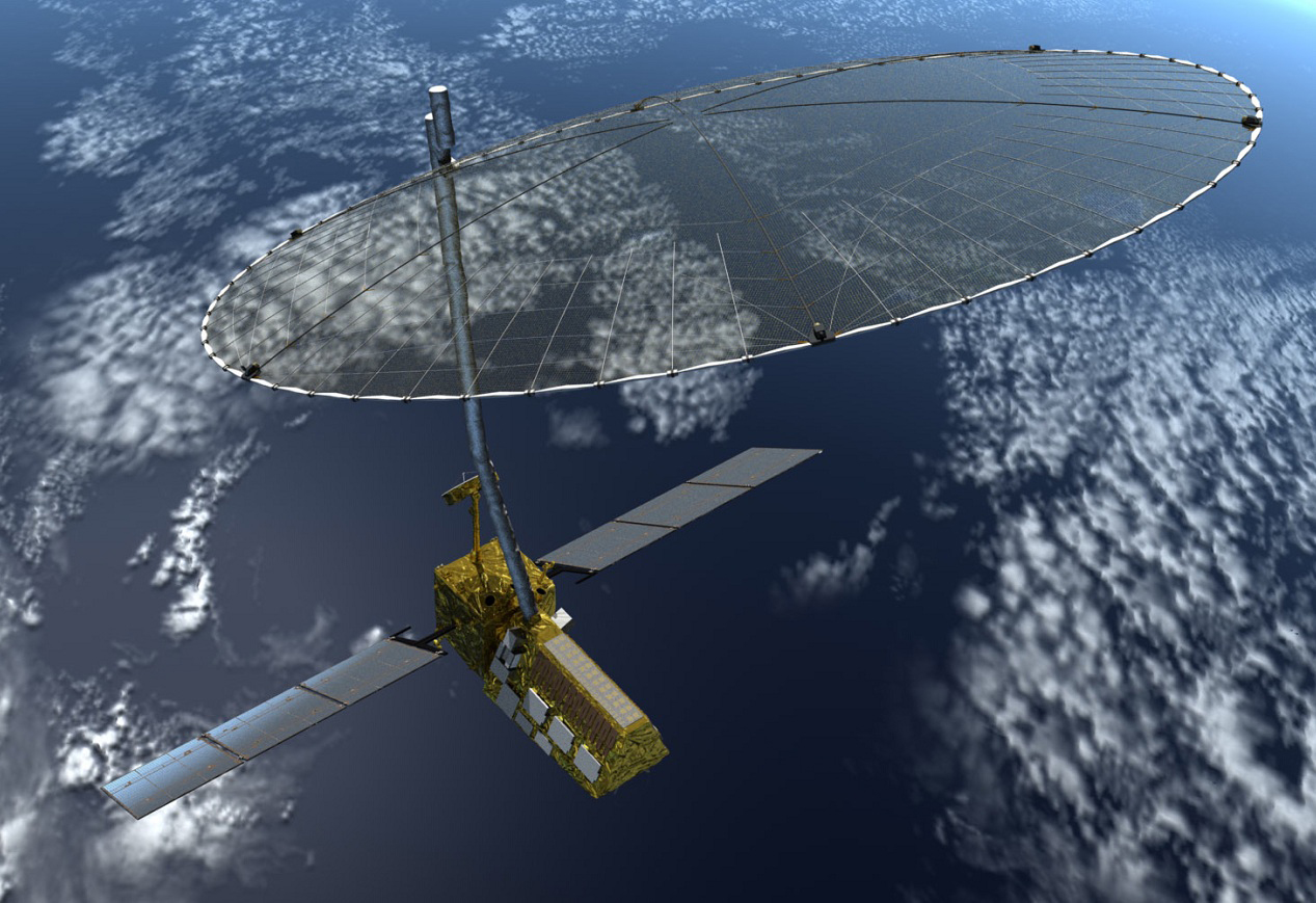
MyAerospace Catalog System Display-RDR-4000 IntuVue™ 3D Weather Radar
IntuVue™ is available on the B777, B737, A320, A330 and A340 as SSFE/BFE equipment. It is also part of the integrated surveillance system the Aircraft Environmental Surveillance System (AESS) on the Airbus A380, it has also been selected for the A350.Other certifications are pending. Be assured that Honeywell will continue to evolve the IntuVue™ family of advanced weather detection radars to offer you increased Efficiency, greater Safety, and enhanced Performance across your fleet.
USMC KC-130T's refuel F18C's
KC-130T
The KC-130T is US Marines Corps Reserves refueling tanker, similar to KC-130R, but with updated avionics, including the Bendix AN/APS-133 radar. The Marine Corps Reserve operates 24 KC-130Ts, but they do not perform the same type of missions as the Navy Reserve C-130T's.

AN/APS-133

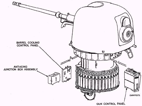
The AN/APS-133(V) which will be replaced by the new radar is one of the most widely used color weather radars in US military service. Based on the commercial RDR-1F radar, the APS-133(V) is fitted to most US Air Force transports as well as several Marine Corps aircraft including the KC-130T. It first entered military service as part of C-141B upgrade in the 1970s. Installed on C-5, C-18, C-130, E-3, E-4, E-6, KC-10, and VC-25 (Air Force One) aircraft. The US Marine Corps introduced the later Type 2 in its aircraft in 1984.
The stabilized parabolic antenna can emit either a pencil or fan beam and has varying scan angle. In the Type 2, the sector scan control panel allows adjustment of the scan angle from 15° to 75° to each side of the centerline, and the cen-terline can vary up to 75° to the right or left of the aircraft’s longitudinal axis. The receiver/transmitter uses a solid-state modulator that transmits on three different pulse widths depending on its mode and has two Pulse Repetition Frequencies (PRFs).

SPECIFICATIONS •
  • BAND I (9.375 GHz)
    TRANSMIT POWER 65 kW
  • RANGE 
    • weather: 300 nm (345 mi; 556 km) 
    • mapping or beacon: more than 250 nm (288 mi; 463 km) 
    • skin painting/air-to-air: 30 nm (34.5 mi; 55.6 km) 
  • PRF 200 or 800 Hz
  • PULSE WIDTH 0.4, 2-35, or 5.0 rmcrosec 
  • SYSTEM WEIGHT 104.4 lb (46.4 kg) 
  • ANTENNA BEAM WIDTH 2.9° (30-in antenna), 4.4° (22-in antenna)
  • ANTENNA SCAN RATE 45°/Sec

RDR-4000M


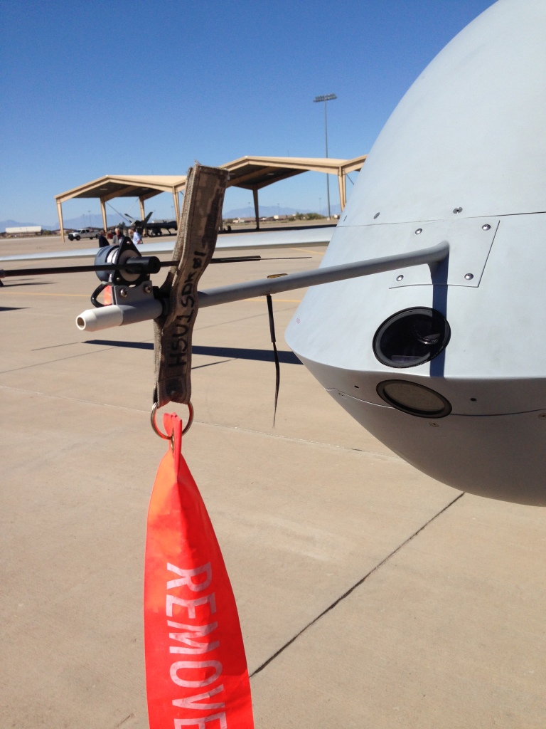
Honeywell IntuVue 3D Weather Radar Selected for US Marine KC-130T
[Avionics Today 10-31-2014] Honeywell Aerospace’s IntuVue 3D Weather Radar System has been selected by the U.S. Navy as part of its upgrade for 14 U.S. Marine Corps KC-130T aircraft.
The IntuVue RDR-4000M incorporates unique functionality, such as skin-paint mode during formation and air refueling operations. Skin-paint mode enables a pilot to detect another aircraft and either home in on it or navigate toward it, without requiring visual contact, or maintain aircraft separation during conditions of reduced visibility. It also makes use of a three-dimensional volumetric buffer to store a complete 3-D map of the weather and terrain visible by the radar, among other functions designed to reduce pilot workload.
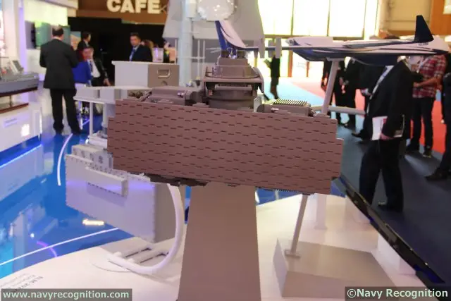
High Resolution Ground Mapping Mode
“Building on a commercial product saves the government critical research and development funds and cycle time by taking advantage of Honeywell’s commercial investment to develop this critical military product,” said Heath Patrick, vice president of the Americas defense aftermarket division of Honeywell Aerospace. “By using the IntuVue RDR-4000M on its KC-130Ts, the U.S. Marine Corps will be better prepared to handle severe weather, hail, lightning and turbulence to conduct efficient and safe missions, thanks to a system that has been proven through millions of flight hours.”

Hercules Operators Conf 2010 - Honeywell-Weather_Radar_Tech-Tom_Henderson.pdf presentation compares the new RDR-4000 with the AN/APS-133 it replaces.

Honeywell’s RDR 4000 Moving into Bizjet Cockpits | Aviation International News


Thursday, October 30, 2014

Thales Introduces Multirole Radar For a Myriad of Mission Types

Thales Introduces Multirole Radar For a Myriad of Mission Types
[Avionics Today 10-29-2014] Thales’ new Searchmaster radar system promises to be a multirole surveillance radar with the ability to meet all the surveillance requirements of five mission types:
  •  anti-surface warfare, 
  • anti-submarine warfare, 
  • maritime surveillance, 
  • ground surveillance and 
  • tactical air support.
The Searchmaster radar features an Active Electronically Scanned Array (AESA) antenna based on technologies developed for the RBE2 AESA nose-mounted radar on the Rafale combat aircraft. The product allows for extended range and electronic scanning in the vertical plane for simultaneous short-range and long-range surveillance, as well as continuous detection in harsh environmental conditions.

Weighing in at approximately 75 kg, Thales claims it is easy to install and integrate with a system. It is suitable for Medium Altitude, Long Endurance (MALE) Unmanned Aerial Vehicles (UAVs), medium-tonnage or heavy-lift mission helicopters and turboprop or jet-engined mission aircraft.
Atlantique 2 (ATL2) maritime patrol aircraft


Euronaval: Thales introduces France's new maritime patrol radar - 10/28/2014 - Flight Global
Thales has introduced its new Searchmaster airborne multirole surveillance radar, which will be supplied to the French navy for its Atlantique 2 (ATL2) maritime patrol aircraft upgrade programme.
The active electronically scanned array radar will be integrated into 15 of the Dassault- built aircraft. French defence procurement agency DGA announced the upgrade programme in October 2013, with the aim of extending the life of the aircraft out to the 2030s.
“The surveillance radar is part of the upgrade package,” armament chief engineer Patrick Aufort, manager officer for mission aircraft at the DGA, said during the launch at the Euronaval exhibition in Paris. “The French navy needs to improve the detection of small targets in high sea states and its coastal surveillance.”

French Navy Picks Terma SCANTER 6000 Radars for Carrier

New Generation of Terma Radar Selected for Charles de Gaulle
Terma has been contracted by French navy ship builder DCNS to supply two SCANTER radars of the type 6000 to the French Navy carrier Charles de Gaulle (R91). It is the largest Western European warship and the tenth French aircraft carrier, commissioned in 2001.


The main task of the SCANTER radars as part of total radar suite aboard the carrier is to serve as a multi-role sensor system to meet requirements for navigation and tactical surface and air surveillance, Search & Rescue, and helicopter control.
Terma has previously delivered and installed the SCANTER 6000 on the French navy’s cutting edge Offshore Patrol Vessel (OPV) “L’Adroit”.

SCANTER 6000

brochure_security___surveillance_radar_scanter_6000_-_naval_surveillance_radar.pdf
The SCANTER 6000 is a coherent X-band 2D solid state radar developed by Terma to address market requirements for improved surface and low airspace situational awareness. It has been specifically designed as an affordable all-weather sensor solution to plug the gap between standard marine navigation radars and more expensive military surveillance radar systems.
Pedersen, J.C., "SCANTER 5000 and 6000 Solid State Radar: Utilisation of the SCANTER 5000 and 6000 series next generation solid state, coherent, frequency diversity and time diversity radar with software defined functionality for security applications," Waterside Security Conference (WSS), 2010 International , vol., no., pp.1,8, 3-5 Nov. 2010
doi: 10.1109/WSSC.2010.5730272
Abstract: 
Coherent, Solid State Radar technology has been available for decades, however, it did not penetrate into harbor surveillance, VTS and related applications for cost and technical reasons. Technically, the main challenge is that dynamic requirements to radar in littoral waters and build up regions are much higher than to other radar applications. Those challenges have now been met and combined with well-renowned advantages from the Terma SCANTER product range. Methods are further refined and implemented on a new technology platform. The result is a software-defined radar series, tailored to individual market segments, virtually unrestricted by dynamic constraints. The digital radar concept with software-defined functionality makes the set-up of the radar easy. Furthermore, Interference rejection against disturbance from radars on ships passing nearby the radar has also proven effective, and the dynamic range has proved to be sufficient to eliminate any artifacts from a high number of large buildings and other structures in an operational area. Operational tests have been performed with impressive results.
URL: http://ieeexplore.ieee.org/stamp/stamp.jsp?tp=&arnumber=5730272&isnumber=5730220

Air Force Hangs Horsehair on MQ-1/9 nose

Why Air Force Drones Rely On Horsehair to Land | Intercepts | Defense News
Sometime in the last 13 years of constant Air Force RPA use, someone decided they needed to know what the winds were like, and specifically what it is doing to the yaw, or the motion of the aircraft on its vertical axis. And that same someone decided hey, when taking off, we have a camera looking straight ahead… so let’s hang something off the front of the system and see how it blows. And hence, the inclusion of horsehair to the front of the Air Force’ fleet of high-tech unmanned systems began. the little low-tech solution actually works out really well during takeoffs

IAI expands maritime ELM-2022 family with the ELM-2022ES and the ELM-2022ML Radars

IAI ELM-2022ES Airborne AESA Maritime Surveillance Radar
IAI ELM-2022ML Airborne Lightweight Maritime Surveillance Radar

World Defence News: IAI officially expands maritime surveillance radar family with the ELM-2022ES and the ELM-2022ML
Developed by ELTA Systems Ltd., a Subsidiary and Group of IAI, it provides maritime / ground surveillance and imaging capabilities in addition to simultaneous air surveillance. IAI's ELM-2022 family is a well established world leader in its category: over 250 systems have been sold to customers in over twenty-five countries worldwide. The radar is currently operated on many platforms including the P-3, Bombardier Dash-8, Airbus Military C-295 and C-235, Dornier 228 Maritime Patrol Aircraft, maritime helicopters and on IAI's Heron 1 Maritime UAV. 
"We are monitoring developing market requirements for performance and size and continue to add new versions and modes of operation to extend the capabilities of our radars," said Nissim Hadas, IAI Executive VP and ELTA President, "these two new members of the ELM-2022 family allow us to provide an optimal solution for every platform category and customer requirement."
Elta Radar Sales Announced | Aviation International News
Elta has also recently achieved more success for its ELM-2022A maritime surveillance radar, which offers a number of modes including inverse SAR. This company has announced separate contracts from two undisclosed customers, with a combined worth of $35 million. More than 100 ELM-2022As are in service on a variety of platforms, including Australia’s P-3 Orions.

The system implements the operating modes and processing algorithms of the ELM-2022 family, while using the unique capabilities of Active Electronically Scanned Array (AESA) technology. The radar system combines mechanical scan in the horizontal plane with fine beam shifting, and full electronic scan in the vertical plane, providing improved detection, particularly at high sea states.

ELM-2022ML Light Weight radar system

This radar uses a unique front-end design in which most of the radar components are installed directly on the mechanical antenna array to achieve a weigh of only 50kg. This radar is suitable for small to medium UAVs as well as light reconnaisance aircraft and helicopters. All modes and capabilities of the existing radar are retained.

Thales Unveils Sea Fire 500 AESA 4 faced Multi Function Radar

Thales' Sea Fire 500 multifunction fixed-array radar
Thales to develop Sea Fire 500, a new multifunction fixed-array radar | Thales Group
Thales to Develop Sea Fire 500, A New Multifunction Fixed-Array Radar
At Euronaval 2014, Thales is announcing the development of its new multifunction naval radar, Sea Fire 500. With a fully solid-state four-panel phased-array antenna, Sea Fire 500 is designed for large surface combatants.
With the combination of its four fully solid-state active fixed arrays, each offering higher power, beam steering agility and 90° coverage, the radar will provide significantly higher detection and tracking performance with continuous 360° coverage in azimuth and 90° coverage in elevation.
Sea Fire 500 is a modular radar system that will be available in several versions and with various antenna sizes to match platform architectures and mission types. Each antenna array is independent: the four fixed panels can be located at different points on the vessel.
Sea Fire 500 will draw on experience gained with the Herakles radar. It is a multifunction radar capable of performing missile fire control and guidance as well as target detection, identification and tracking.
FREMM multipurpose frigate - Wikipedia, the free encyclopedia
At Euronaval 2012 DCNS showed a new concept called FREMM-ER for the FREDA requirement, again based on the FREMM, but specifically mentioning the ballistic missile defence mission as well as anti-air. FREMM-ER has a modified superstructure replacing Héraklès with the new Thales Sea Fire 500 radar, whose four fixed plates resemble those of the US Navy's AN/SPY-1.[7] However unlike the Héraklès and the SPY-1 (both using passive electronically scanned array technology), the Sea Fire 500 has active electronically scanned array antennas.[8]
Aquitaine, 1st of 12 FREMM-ER frigates built by DCNS
13/4_DCNS_FREMM-ER
The FREMM-ER features an ­integrated combat system to provide accurate multi-sensor tactical ­pictures with monitoring and decision-making aids that are designed to reduce workload during operations. Olivier Casenave-Péré, Director of the DCNS Canada office, believes the most significant enhancement of the FREMM-ER is its situational awareness package, which integrates the latest ­generation of Multi-Function Radar with four fixed Active Electronically Scanned Array (AESA) panels. Combined with the SETIS combat management system’s powerful algorithms, such radar is designed to perform well even in the most challenging environments, including for BMD capability.

Wednesday, October 29, 2014

Thales PASTOR Multi-Sensor Counter-Piracy Solution for Commercial Vessels


Thales launches PASTOR counter-piracy service solution | Thales Group

Thales Unveils Unique Counter-Piracy Service Solution

  • Four missions: 
    • threat detection (radar), 
    • identification (optronics), 
    • deterrence (searchlight) and 
    • protection measures in the event of an
      attack.
  • Benefits: 
    • enhanced protection for crew, 
    • reduced risk of kidnapping &
      ransom situations, 
    • lower costs associated with piracy 
      • (insurance
        premiums, 
      • theft of cargo, 
      • route changes, 
At Euronaval 2014, Thales is unveiling PASTOR, a unique service solution to protect vessels against piracy. Primarily designed for shipping companies, this high-level services solution is based on a combination of early warning, prevention and deterrence systems.

PASTOR comprises detection (radar) and identification (gyrostabilised optronic system) functions to provide the vessel's security officer or onboard protection team with early warning of any potential piracy threat. It includes a powerful searchlight to act as a deterrent and ward off attackers. The solution includes intuitive data management software which automatically issues alerts and provides the relevant authorities with clear and simple information about an attack. An automated digital radio system enables vessels in the vicinity to identify each other. 
Euronaval: Thales launches Pastor anti-piracy solution - News - Shephard
Jean-Michel Negret, C4I product line manager for Thales, said the company had developed a new radar in the form of the Furuno-based NW10 radar – currently the only ‘civil radar designed to detect and track small targets at long range in high seas’.

Radar Alternatives are Available from Raymarine and Kelvin Hughes


details of the NW10 radar are not provided, but if this is a Magnetron type, its performance against small fast moving targets in heavy clutter is probably inferior to the SharpEye.
Kelvin Hughes SharpEye Solid-State Radar Systems | Marine Systems
SharpEye™ is a digital radar technology which is available both in X and S band frequencies. It is a radical and innovative departure from current marine navigation radar technology in that it has no magnetron and uses a coherent transmission, which means that SharpEye™ is able to separate targets from clutter due to their differing radial velocity components. This extra dimension gives a significant performance advantage in detecting small targets in clutter resulting in safer ship operations. 
Furuno and Raymarine Radar Systems | Yachting Magazine
These new digital high-definition radars are components of their manufacturers latest integrated multifunction navigation, NavNet 3D from Furuno and the G-Series Navigation System from Raymarine. Radar images can be displayed individually, in a split screen mode that provides the full functionality of having two complete radars on board, or overlaid on the navigation chart. The introduction of both of these comprehensive navigation systems marks a significant advance in the state of the art for this class of equipment.

The radar images on both the Furuno and Raymarine multifunction displays were clearly superior to their previous offerings. Both very small and quite massive targets were very sharply defined. The screens were remarkably free of sea clutter and other normally encountered intermittent interference. Both radars can be operated in a simultaneous dual-range mode, providing the functional advantage of two separate radars.

Other manufacturers, including Garmin, JRC and Northstar, have offered yacht radars that process the received signal digitally, however they have not yet achieved the level of performance or struck the spark of excitement that the combination of features incorporated in these new (and somewhat more costly) Furuno and Raymarine units are likely to create, especially when the advanced simultaneous dual-range features of these systems are viewed on their new NavNet 3D and G-Series chart plotter displays.
Raymarine Marine Radar Features

Pastor Threat Identification and Tracking

Once the radar has detected a potential threat, a gyro-stabilised EO/IR and camera system is used to make a positive identification and provide the vessel's security officer or onboard protection team with early warning.
The camera system includes a powerful searchlight to act as a deterrent while the supporting software includes data management that automatically issues alerts and provides the relevant authorities with information about an attack.

Pastor System Packaging

Thales is offering Pastor as a bronze, silver and gold service, with

  • bronze including just the equipment;
  • silver the addition of private security contractors; and
  • gold the inclusion of a shore-based command centre.

The kit can be bought outright or leased from the company as a service with the latter costing less than €1000 a day.

Previously:

spendergast: Using Ground Surveillance Radar and Multiple Sensors for Airport Security
The PASTOR system seems to be similar in design to a system I designed and marketed when working for CACI back in 2006 based on the IMPASS airport security concept for security of ships such as supertankers, and large installations at sea such as drill platforms. It included automated target detection and sensor fusion, with remote monitoring from a global command center. 

Navy Gun Parts from FFG-7 to be reused on USCG Cutters

Oto Melara Mk 75 76mm/62
Navy Harvests Decommissioned Frigates' Weapon Systems for Coast Guard | Military.com
PHILADELPHIA -- Engineers at Naval Ship Systems Engineering Station (NAVSSES), Naval Surface Warfare Center Carderock Division are harvesting weapon system components from decommissioned U.S. Navy frigates (FFGs) for re-use on Coast Guard cutters.


The harvesting of components from four decommissioned frigates will result in more than $24 million in cost avoidance, with more expected from a fifth ship. The Navy's leveraging of decommissioned ships' assets shows a judicious use of resources and collaboration between services.
The equipment includes MK 75, 76mm/62 caliber gun
  • mounts, as well as 
  • gun control panels, 
  • barrels, 
  • launchers, 
  • junction boxes and other components. 

The Coast Guard can use all of this equipment on cutters during the course of the ships' expected service life, which spans into the 2030s.

The MK 75 gun is suitable for installation on small combatants due to its light weight, and low manpower requirements. One gun mount is installed aboard USN frigates and larger USCG cutters. The MK 75 was provisionally approved for service use in September 1975.

BAE Systems (The former Naval Systems Division (NSD) of FMC Corporation) and General Electric Co. (Ordnance Systems Division) were licensed by the gun's designer, OTO Melara of La Spezia, Italy, and competed for the right to manufacture the MK 75 in the United States. In 1975, BAE systems won the competition. Since 1981, all MK 75 buys have been competed between BAE systems and OTO Melara. The U.S. Navy is no longer acquiring MK 75 guns but has logistics support contracts with BAE systems and OTO Melara. 
The 76-MM MK 75 Gun
The Mk 75 gun is a fully automated, remotely controlled gun mount that stows, aims, and fires 76-mm, 62-caliber ammunition. The system is currently aboard FFG-7 and PHM class ships along with the Mk 92 FCS. The design of the gun mount makes extensive use of lightweight corrosion-resistant alloys and modem engineering techniques. The result is a lightweight, compact, fast-firing, versatile weapon. It is primarily a defensive weapon used to destroy antiship cruise missiles. However, it can also be effectively used against surface and shore targets. The gun has a variable rate of fire of up to 80 rounds per minute with a range of up to 16,459 meters and a maximum altitude of 11,519 meters. The most notable innovation featured on this system is the automatic barrel cooling system. This allows sustained operation at high rates of fire without excessive barrel wear or the danger of a "cook off" if a misfire occurs.

Tuesday, October 28, 2014

RAND: Better Nurse Staffing Improves Quality of Patient Care with no Increase in Costs

Examining the Value of Inpatient Nurse Staffing: An Assessment of Quality and Patient Care Costs | RAND

Background:

Inpatient quality deficits have important implications for the health and well-being of patients. They also have important financial implications for payers and hospitals by leading to longer lengths of stay and higher intensity of treatment. Many of these costly quality deficits are particularly sensitive to nursing care.

Objective:

To assess the effect of nurse staffing on quality of care and inpatient care costs.

Design:

Longitudinal analysis using hospital nurse staffing data and the Healthcare Cost and Utilization Project State Inpatient Databases from 2008 through 2011.

Subjects:

Hospital discharges from California, Nevada, and Maryland (n=18,474,860).

Methods:

A longitudinal, hospital-fixed effect model was estimated to assess the effect of nurse staffing levels and skill mix on patient care costs, length of stay, and adverse events, adjusting for patient clinical and demographic characteristics.

Results:

Increases in nurse staffing levels were associated with reductions in nursing-sensitive adverse events and length of stay, but did not lead to increases in patient care costs. Changing skill mix by increasing the number of registered nurses, as a proportion of licensed nursing staff, led to reductions in costs.

Conclusions:

The study findings provide support for the value of inpatient nurse staffing as it contributes to improvements in inpatient care; increases in staff number and skill mix can lead to improved quality and reduced length of stay at no additional cost.


UCSD Engineer and Del Mar Film Maker follow Roosevelt route in Amazon 100 years later

UCSD explorer struggling in Amazon | UTSanDiego.com
UC San Diego engineer Marc Meyers and Emmy Award-winning Del Mar filmmaker Jeffrey Lehmann are traveling on the River of Doubt in Brazil, retracing the path that Theodore Roosevelt followed a century ago. Meyers and Lehmann are sending periodic dispatches to the U-T from the jungle. This dispatch was received on Oct. 27th, and was written by Lehmann.

xxx
GOING WHERE TEDDY ROOSEVELT DARED A CENTURY AGO | UTSanDiego.com - 03-17-2014.pdf
Roosevelt River - Wikipedia, the free encyclopedia
Formerly called Rio da Dúvida (“River of Doubt”), the river is named after Theodore Roosevelt, who traveled into the central region of Brazil during the Roosevelt-Rondon Scientific Expedition of 1913–14. The expedition, led by Roosevelt and Cândido Rondon, Brazil's most famous explorer and the river's discoverer, sought to determine where and by which course the river flowed into the Amazon.
Roosevelt and his son Kermit undertook the adventure after the former U.S. president's failed attempt to regain the office as the "Bull Moose" candidate in 1912. The Roosevelt-Rondon expedition was the first non Amazonian-native party to travel and record what Rondon had named the "Rio da Dúvida", then one of the most unexplored and intimidating tributaries of the Amazon. Sections of the river have impassable rapids and waterfalls, which hindered the expedition.
UCSD Jacobs School of Engineering -  Marc Meyers  
Marc Meyers came to the Jacobs School in 1988 and had a stint as Director of UCSD's Institute for Mechanics and Materials. Prior to that he was Adviser to the Director, Materials Science Division, U. S. Army Research Office, Durham, North Carolina; and Associate Director, Center for Explosives Technology Research. He is co-founder of the EXPLOMET conferences. His books, Dynamic Behavior of Materials, and Mechanical Behavior of Materials are key textbooks worldwide. He is a fellow, ASM International, among other honors. He received his Ph.D. in 1974 in Physical Metallurgy from the University of Denver.
11 results for Books : "Marc André Meyers"
::Dr. Marc A. Meyers, University of California, San Diego, UCSD::

Jeffrey Lehmann's Page - Frontera Filmmakers

Chinese enter into Iridium like LEO Satcom Business

Wang Jing, Chinese tycoon behind Nicaragua Canal, now wants to build satellite communication network | South China Morning Post
Wang Jing told a press briefing in Beijing yesterday that his company, Xinwei Telecom Enterprise Group, launched a low-earth orbit satellite last month in Inner Mongolia in a joint venture with Tsinghua University.
It makes Xinwei the first private enterprise in the country to invest in the closely guarded space industry, Wang said.

China tycoon announces plans for satellite communication networkNation - China Daily Asia
The satellite, developed with Tsinghua University, was expected to provide a cheaper alternative to foreign satellite communication providers in China's sea and desert areas, Beijing News said, citing Tsinghua Professor Lu Jianhua.
Wang said Xinwei planned to develop four more satellites with the university and build a telecommunication "constellation" over the next 10 years, the report said.
"The cost of building the satellites with homegrown technology is very low and so we have high expectations on the return on investment in the future," Wang was quoted as saying.

Desert Ocean comprehensive coverage smart will open China Iridium Time | eLearning In China
[machine translation follows] On the 26th, Tsinghua University and Xinwei Group jointly announced: China's first low-orbit satellite mobile communications – smart communications test satellite (hereinafter referred to as smart) has completed all the success in-orbit testing test engineering tasks.

Industry sources said the trial is successful this private satellite, indicates that China has not only achieved LEO satellite mobile communication technology an important breakthrough for the construction of a key step towards the constellation communications system, also created a collaborative innovation of private enterprises and universities to participate in aerospace The new mode of communications.
For the national strategic needs, private enterprises and universities together to test the water space communications.

According to reports, smart communications test satellite weighs about 130 kg, runs on an altitude of about 800 km sun-synchronous orbit.

... the absence of its own low-orbit communication satellites, currently more than 80 percent of China's land area, the communication network covering more than 95% of marine areas are still facing problems, fishermen, ocean sailing, mountainous forest operations yet inexpensive and effective . Thus, through innovation, build self-control, security and sustainable development in the constellation communications system, has become an urgent strategic needs. Meanwhile, the constellation communications system needs to have dozens of satellites joint operations in order to achieve full coverage of communication. Therefore, the establishment constellation communications system is not only huge investment, and technical difficulties, the risk is high.

Department of Electronic Engineering,Tsinghua University

Made-in-China satellites look to more global partners - CCTV News - CCTV.com English

The launch of the Long March 2A rocket carrying the Ling Qiao
satellite from Jiuquan Satellite Launch Center on Sept. 4.
(Photo/Xinhua)
Tests of China's first low-earth orbit comsat complete|Politics|News|WantChinaTimes.com
The Ling Qiao, China's first low-earth-orbit communications satellite (comsat), designed by Beijing's Tsinghua University and Xinwei Telecom Enterprise Group, has completed its orbit test, marking a breakthrough for China, reports the website of China's Global Times.
Weighing 130 kilograms, the satellite runs at a Sun-synchronous orbit with an altitude of about 800 kilometers, covering an area 2,400 km in diameter. China launched the satellite with the Long March 2A rocket from the Jiuquan Satellite Launch Center Sept. 4, starting an in-orbit test communications task between mobile phones and hand-held GPS devices.

Pharma Pays $825 Million to Doctors and Hospitals, ACA’s Sunshine Act Reveals

Pharma Pays $825 Million to Doctors and Hospitals, ACA’s Sunshine Act Reveals

A not so well-known provision of the Affordable Care Act is the Sunshine Act. The purpose of this act is to increase the transparency in the health care market by requiring doctors, hospitals, pharmaceutical companies, and medical device manufacturers to disclose their financial relationships. Mandated by the Sunshine Act, on September 30th, Centers for Medicare and Medicaid Services (CMS) publicly released the first set of data, under the Open Payments title. This data includes $3.5 billion paid to over half a million doctors and teaching hospitals in the last five months of 2013.
A subset of Open Payments data that is individually identifiable  includes two categories of payments. The first category are the payments that are made for other reasons such as travel reimbursement, royalties, speaking and consulting fees and the second are payments which are made as research grants. These datasets together include more than 2.3 million financial transactions which amount to a total of more than $825 million.

Doctors net billions from drug firms - Yahoo Finance 

Drug and medical-device companies paid at least $3.5 billion to U.S. physicians and teaching hospitals during the final five months of last year, according to the most comprehensive accounting so far of the financial ties that some critics say have compromised medical care.
The figures come from a new federal government transparency initiative. The 2010 Affordable Care Act included a provision dubbed the Sunshine Act, which requires manufacturers of drugs and medical devices to disclose the payments they make to physicians and teaching hospitals each year for services such as consulting or research. The Centers for Medicare and Medicaid Services compiled the records into a database posted online Tuesday, though the agency said that about 40% of the payment information won't identify the recipients because of data problems.
The database revealed some eye-popping totals, such as the $122.5 million paid by Roche Holding AG's Genentech unit to City of Hope medical center in Duarte, Calif., as royalties on sales of several products including blockbuster cancer treatments Herceptin and Avastin.

What We’ve Learned From Four Years of Diving Into Dollars for Docs - ProPublica

What to be Wary of in the Govt’s New Site Detailing Industry Money to Docs - ProPublica

  • * The data doesn’t cover all payments.
  • * By design, some data on research payments won't be included.
  • * Because of errors, additional data isn't being released.
  • * Not all payments have the same significance. 
  • * This is the first federal release of this data: Expect errors.    

CMS Issues Final Rule on “Sunshine” Provisions of ACA - 2013 - Washington Highlights - Government Affairs - AAMC

February 8, 2013—The Centers for Medicare and Medicaid Services (CMS) issued a Feb. 8 final rule on the physician payment sunshine provisions of the Affordable Care Act (ACA, P.L. 111-148 and P.L. 111-152).  The rule, “Transparency Reports and Reporting of Physician Ownership or Investment Interests,” requires manufacturers of drugs, devices, biologicals, and medical supplies to report annually to CMS any payments or transfers of value made to physicians and teaching hospitals.
Under the final rule, those manufacturers must begin collecting payment data on Aug. 1, 2013.  The data collected for the remaining five months of 2013 must be reported to CMS by March 31, 2014.  The resulting database will be made publicly available by Sept. 30, 2014.


Physician Payment Sunshine Act
Physician Payment Sunshine Act: A Primer | Research | American Action Forum
Toolkit for Physician Financial Transparency Reports (Sunshine Act)

Open Payments - Centers for Medicare & Medicaid Services


Sunday, October 26, 2014

Dark Matter Eludes Observers

x

Dwarf Galaxies Dim Hopes of Dark Matter | Quanta Magazine
Once again, a shadow of a signal that scientists hoped would amplify into conclusive evidence of dark matter has instead flatlined, repeating a maddening refrain in the search for the invisible, omnipresent particles.
The Fermi Large Area Telescope (LAT) failed to detect the glow of gamma rays emitted by annihilating dark matter in miniature “dwarf” galaxies that orbit the Milky Way, scientists reported Friday at a meeting in Nagoya, Japan. The hint of such a glow showed up in a Fermi analysis last year, but the statistical bump disappeared as more data accumulated.

LUX dark-matter search comes up empty - physicsworld.com
Dark Matter Still Hiding: Latest Experimental Sweep Comes Up Empty - Scientific American 
The Large Underground Xenon (LUX) dark-matter detector at the Sanford Underground Research Facility in the US has failed to find any evidence for dark matter in the first three months of its operation. One of the world's most sensitive dark-matter detectors, LUX has managed to put more stringent limits on what dark matter could be. In particular, the preliminary results suggest that previous hints of low-mass dark-matter particles reported by some other experiments might not be credible.

Could dark matter be the modern "Luminiferous Aether" - how sensitive will experiments have to be to get a Michelson Morley result and a new Einstein comes along?

Dark Energy and Beyond-jain.pdf

2/19/14
Bhuvnesh Jain (U. Penn)
The discovery that our universe is accelerating poses fascinating challenges for physics and astronomy. Vacuum energy, more generally called dark energy, is a possible explanation for the observed cosmic acceleration. Modifications to Einstein's general relativity are being explored as alternatives to dark energy. I will describe the theoretical motivations and experimental tests of gravity theories and other effects involving dark sector couplings. On large scales, they require a different take on cosmological observations such as gravitational lensing and large-scale structure in the universe. On much smaller scales the new tests of gravity use pulsating stars, rotating disk galaxies and other astronomical phenomena. I will describe how these diverse observations are being used to look "beyond dark energy".