 |
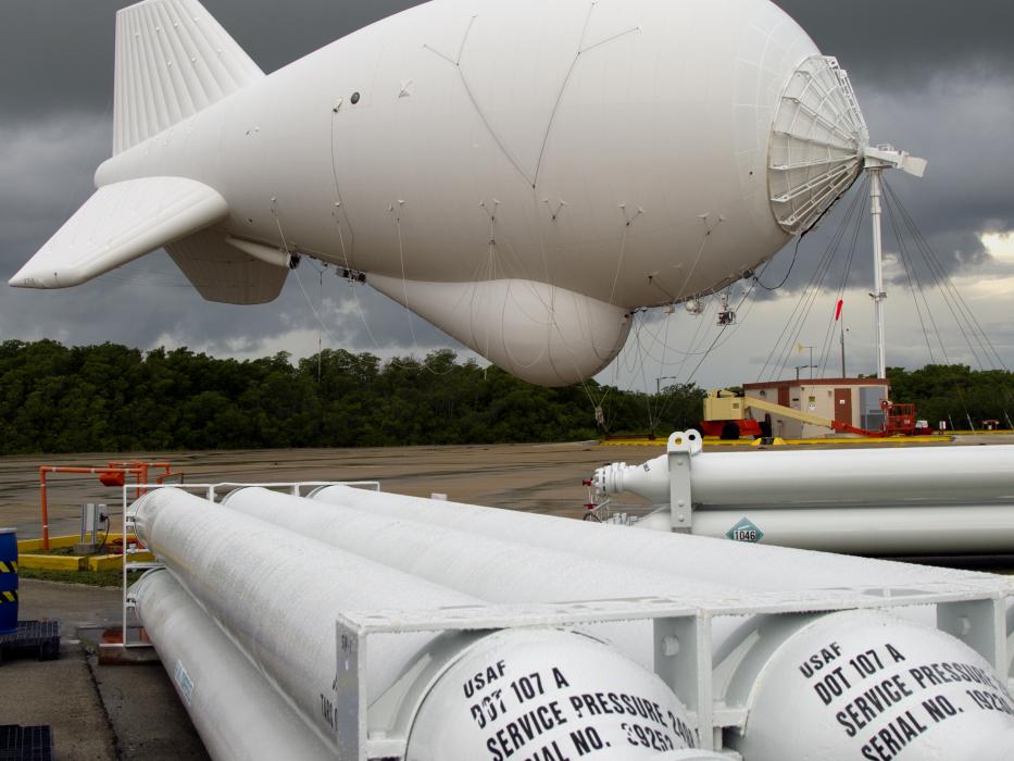
| Preparing TARS for launch |
: Added: Feb 25, 2015 2:51 pm
Through this RFI, the Department of Homeland Security (DHS) Customs Border Protection (CBP) Office of Innovations Technology and Acquisition Office (OTIA) is seeking informational responses and comments from industry to provide CBP with insight into market conditions,
availability of technology and innovative business approaches that will aid in the development of an acquisition strategy for advancement of the Tethered Aerostat Radar System (TARS) to improve performance in meeting the agency mission objectives at a lower cost.
Companies may submit questions regarding this RFI to the Government within 5 days after release of this RFI. Response submissions and/or questions to this RFI should be submitted by e-mail to: TARSRFI@cbp.dhs.gov . All questions will be published via https://www.fbo.gov. Submissions will be due 30 days after the Government posts answers to industry questions.
_0.jpg?itok=5hXj7UOv) |
| Current TARS locations |
Tethered Aerostat Radar System | U.S. Customs and Border Protection
The Tethered Aerostat Radar System (TARS) is an aerostat-borne surveillance system that provides wide area persistent long-range radar detection and monitoring (radar and electro-optical/infrared
surveillance) for interdiction of low-flying aircraft and maritime/ground traffic in support of the CBP strategic objective. TARS balloons are tethered to ground stations while flying with sensor payloads, at approximately 10,000 feet. There are six (6) TARS sites operating along the United States-Mexico
border, with two additional sites monitoring the Florida Straits, and a portion of the Caribbean south and west of Puerto Rico.
The TARS system, while continuing to provide a cost-effective capability to CBP, is aging and fragile. The mission sensor (radar) technology is over 20 years old and no longer produced, while several key ground system components are no longer original equipment manufacturer
(OEM) supported. This overall obsolescence issue decreases operational availability stemming from higher maintenance cycles, as well as increasing maintenance costs commensurately. These performance and cost concerns are expected to worsen in the coming years, adding to the overall resourcing challenges CBP is addressing through the TARS follow-on acquisition strategy
Related Links
- Description - BorderSurveillance.pdf
- Microsoft PowerPoint - LTA-Final Flag Brief - 2005_brief_lighter_than_air.pdf
- spendergast: U.S. Army's JLENS Aerostat Radar System demos NORAD interoperability
Background
x
Frontline November Aerostats | U.S. Customs and Border Protection
Eyes in the sky stretch over the southern U.S. border at 10,000 feet, from Yuma, Arizona, to Lajas, Puerto Rico. Eight special blimps that are part of the Tethered Aerostat Radar System, or TARS, watch over the southern U.S. border. Each balloon is moored to the ground with a special nylon fiber cable, and raised and lowered with a powered winch.
Swaying silently in the breeze, U.S. Customs and Border Protection aerostats are unmanned, unarmed, and spend their service lives hovering over a fixed location on the southern edge of the border. “TARS is the most cost-efficient capability that we own,” according to Richard Booth, director of domain operations and integration for CBP’s Office of Air and Marine. “TARS is like a low-flying satellite system, but cheaper to launch and operate,” Booth explained.
“The aerostats are aerodynamic balloons and fly like kites in the wind—no one pilots them,” said Rob Brown, CBP program manager for TARS. "Raising radar and other sensors to high altitude boosts surveillance range, and the physical sight of an aerostat is a visual deterrent to illegal activity in the air and on the ground," explained Brown. Each TARS balloon contains a radar weighing about 2,200 pounds, capable of detecting aircraft at a range of 200 miles.
Exelis - Tethered Aerostat Radar System (TARS)
TARS provides persistent, long-range detection and monitoring (radar surveillance) capability for interdicting low-level air, maritime and surface smugglers and narcotics traffickers along the United
States-Mexico border, the Florida Straits, and a portion of the Caribbean. The TARS program provides surveillance data to the Customs and Border Protection (CBP) Office of Air and Marine (OAM) Operations Center (AMOC). As a secondary mission, TARS supports the USNORTHCOM and USSOUTHCOM air surveillance missions. In addition, TARS surveillance data also supports the North American Aerospace Defense Command (NORAD) air sovereignty mission for the continental United States. The TARS capability is optimized to detect low, slow flying aircraft within its area of coverage.
Factsheets : Tethered Aerostat Radar System
The TARS program uses two different sizes of aerostats, categorized by volume. The 275,000 cubic foot, or 275K, aerostat is 186 feet long and 62.5 feet in diameter with a fin span of 68.6 feet. The 420,000 cubic foot, or 420K, aerostat is 208.5 feet long and 69.5 feet in diameter with a fin span of 75.5 feet. These aerostats an rise up to 15,000 feet mean sea level, while tethered by a single nylon and polyethylene constructed cable. The normal operating altitude varies by site, but the norm is approximately 12,000 feet MSL. Aerostat power is developed by an on-board, 400 Hertz generator. The aerostat also carries a 100-gallon diesel fuel tank. All systems, to include the generator are controlled via an aerostat telemetry link.
The TARS program currently uses a Lockheed Martin, L-88A or L-88(V)3 radar. All radar data is transmitted to the ground station then digitized and fed to the various control centers for display. The ground station is where a flight director, seated before banks of meters and television screens, monitors the aerostat's performance. A doppler weather radar, wind profiler and ground weather station are installed at each site to support flight operations. Each site also obtains up-to-date forecasts and weather warnings from the Air Force Weather Agency.
No comments:
Post a Comment