 |
| Color composite image showing four-year variation of forest cover in western Indonesia and Malaysia. |
 |
| Global mosaics show phased-array type L-band synthetic
aperture radar-2 color composites in (top) horizontal transmission/ reception (HH), horizontal transmission/vertical reception (HV), and HH/HV modes in red, green and blue, respectively, and (bottom) the corresponding map of forest areas (green)/non-forest areas (yellow) |
Masanobu Shimada, Takuya Itoh, Takeshi Motooka, Manabu Watanabe and Rajesh Thapa
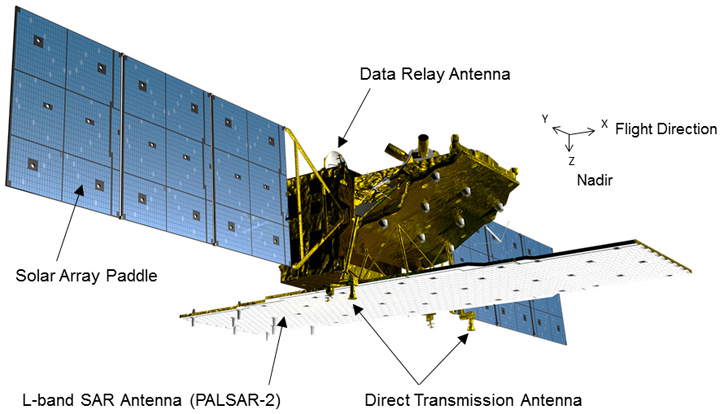 |
| ALOS-2 Overview |
The PALSAR-2 aboard ALOS-2 is an L-band
Synthetic Aperture Radar(SAR)
sensor, a microwave sensor that emits L-band radio waves and receives
their reflection from the ground to acquire information. Selecting the
most suitable mode for an objective will maximize the effectiveness of
monitoring works. The PALSAR-2 has three modes:
- Spotlight mode -The most detailed observation mode with 1 by 3 meters resolution (observation width of 25 km)
- Strip Map mode - A high-resolution mode with the choice of 3, 6 or 10 meters resolution (observation width of 50 or 70km)
- ScanSAR mode -A broad area observation mode with observation width of 350km or 490km, and resolution of 100m or 60m respectively
We first estimated the global forest area as 38,542,500km2 from the ALOS/PALSAR data set,4 following the Landsat-based estimation of forest area as 40,656,570km2.5 The difference can probably be attributed to a difference in the sensitivity of optical and L-band SAR techniques in measuring forest cover. Maps of forest/non-forest areas provide basic information for the interpretation of forest cover, so we anticipate the frequent generation of L-band SAR mosaics and related forest/non-forest maps from the forthcoming ALOS-2/PALSAR-2 data set.
No comments:
Post a Comment