Mapping glacier velocity From Space
GLIMS: Global Land Ice Measurements from SpaceGLIMS (Global Land Ice Measurements from Space) is a project designed to monitor the world's glaciers primarily using data from optical satellite instruments, such as ASTER (Advanced Spaceborne Thermal Emission and reflection Radiometer).
Sizing Up the Earth's Glaciers : Feature Articles
Observing glacier change from space
Measuring regional glacier and ice stream velocity, and its change through time, is a critical application of glacier remote sensing. There are several methods; the first relies on repeated optical satellite imagery of one region. An algorithm applied to the images calculates the distance that features on the ice surface have moved (feature tracking) (e.g., 27). Cosi-Corr is frequently used for feature tracking in this way31,32. A second method uses repeat radar images (Synthetic Aperture Radar interferometry, or InSAR) to calculate glacier velocity. Two pairs of images are used to calculate ascending-pass and descending-pass interferograms. Velocity fields can then be calculated6.
Ice velocity on George VI Ice Shelf
For example, Tom Holt used a combination of radar and optical feature tracking to examine the response of George VI Ice Shelf to environmental change6. This analysis showed ice-shelf acceleration towards the north and south ice fronts, combined with thinning throughout and an increase in fracture distribution towards the southern ice front.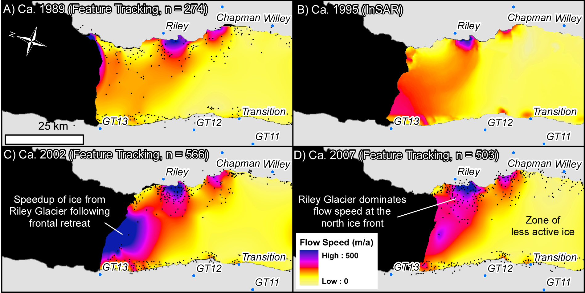
Surface
speed calculations at the north ice front of George VI Ice Shelf for
ca. 1989 (A), 1995 (B), 2002 (C) and 2007 (D). From Holt et al., 2013.
Mapping Antarctic ice stream velocity
 |
| ICEsat data is used to map the ice streams around Antarctica. Image made using velocity data from Rignot et al. 2011 |
From the Air


High-Altitude Radar Measurements of Ice Thickness Over the Antarctic and Greenland Ice Sheets as a Part of Operation IceBridge
- Abstract—The National Aeronautics and Space Administration (NASA) initiated a program called Operation IceBridge for monitoring critical parts of Greenland and Antarctica with airborne LIDARs until ICESat-II is launched in 2016. We have been operating radar instrumentation on the NASA DC-8 and P-3 aircraft used for LIDAR measurements over Antarctica and Greenland, respectively. The radar package on both aircraft includes a radar depth sounder/imager operating at the center frequency of 195 MHz. During high-altitude missions flown to perform surface- elevation measurements, we also collected radar depth sounder data. We obtained good ice thickness information and mapped internal layers for both thicker and thinner ice. We successfully sounded 3.2-km-thick low-loss ice with a smooth surface and also sounded about 1-km or less thick shallow ice with a moderately rough surface. The successful sounding required processing of data with an algorithm to obtain 56-dB or lower range sidelobes and array processing with a minimum variance distortionless response algorithm to reduce cross-track surface clutter. In this paper, we provide a brief description of the radar system, discuss range-sidelobe reduction and array processing algorithms, and provide sample results to demonstrate the successful sounding of the ice bottom interface from high altitudes over the Antarctic and Greenland ice sheets.
- Index Terms—High-altitude ice sheet measurements, ice surface clutter reduction, multichannel airborne radar.
From the Surface -
Profiles with pRES Radar
 | |
| CD Sept 2015 (Tarmac) - UCL New Radar Measurement System & Workshop |
| Jonathan Kingslake and Howard Conway - Academia.edu
Abstract
We describe a geophysical technique to measure englacial vertical velocities through to the beds of ice sheets without the need for borehole drilling. Using a ground-based phase-sensitive radio echo sounder (pRES) during seven Antarctic field seasons, we measure the temporal changes in the position of englacial reflectors within ice divides up to 900m thick on Berkner Island, Roosevelt Island, Fletcher Promontory, and Adelaide Island.Recorded changes inreflector positions yield “full-depth”profiles of vertical ice velocity that we use to examine spatial variations in ice flow near the divides.We interpret these variations by comparing them to the results of a full-Stokes simulation of ice divide flow, qualitatively validating the model and demonstrating that we are directly detecting an ice-dynamical phenomenon called the Raymond Effect. Using pRES, englacial vertical ice velocities can be measured in higher spatial resolution than is possible using instruments installed within the ice. We discuss how these measurements could be used with inverse methods to measure ice rheology and to improve ice core dating by incorporating pRES-measured vertical velocities into age modeling.


Lai Bun Lok; Brennan, P.V.; Nicholls, K.W.; Corr, H.F.J., "ApRES:
Autonomous phase-sensitive FMCW radar, for basal monitoring and imaging
of antarctic ice shelves," in Antennas, Wireless and Electromagnetics 2014, IET Colloquium on , vol., no., pp.1-16, 27-27 May 2014
doi: 10.1049/ic.2014.0019
doi: 10.1049/ic.2014.0019
- Abstract: A ground-based phase-sensitive FMCW radar system, and associated signal processing algorithms, have been developed at UCL[start [Radar Research Group Wiki]] for millimetre-precision monitoring of Antarctic ice shelf thickness to derive basal melt rates [1]. To support the practical realisation of this radar, and to confirm that suitable performance is obtained, rigorous bench testing have been performed. These tests were conducted on the prototype radar system using coaxial cables in the laboratory at room temperature and to -15°C. Since 2011, the radar system has successfully acquired sounding data from various field locations in Antarctica. The phase-sensitive radio echo sounding (pRES) technique was originally demonstrated by scientists at the British Antarctic Survey for monitoring ice-shelf melt rates, requiring millimetre-precision range measurements [3]. pRES is a stepped-frequency radar implemented using a commercial, laboratory-grade, vector network analyzer. However, it has drawbacks such as high power consumption (1kW petrol generator needed), low portability, high noise figure, and therefore the measurement datasets are limited in length because the instrument cannot be left unattended. This presentation describes our custom-designed radar instrument, based on a novel phase-sensitive FMCW technique [1] and low-cost antenna arrays, which has been developed to enable year-round monitoring and imaging of ice-shelves.
- keywords: {glaciology;ground penetrating radar;hydrological equipment;hydrological techniques;Antarctic ice shelf thickness;Antarctic ice shelves imaging;Antarctica;ApRES;British Antarctic survey;autonomous phase-sensitive FMCW radar;basal melt rates;basal monitoring;coaxial cables;custom-designed radar instrument;ground-based phase-sensitive FMCW radar system;high noise figure;millimetre-precision monitoring;pRES technique;phase-sensitive radio echo sounding;prototype radar system;signal processing algorithms;vector network analyzer},
- URL: http://ieeexplore.ieee.org/stamp/stamp.jsp?tp=&arnumber=6905935&isnumber=6858128
No comments:
Post a Comment