 |
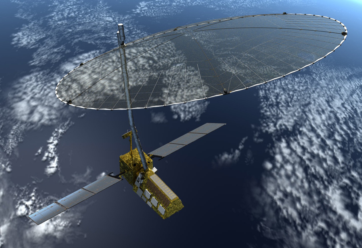
| Artist concept of the Nasa-Isro Synthetic Aperture Radar (NISAR) satellite in orbit. |
Nasa And Isro to Work on Earth Observing Satellite And Future Mars Missions
US and India set to collaborate on Mars mission | Daily Mail Online
JPL | News | U.S., India to Collaborate on Earth, Mars Missions
In a meeting Tuesday in Toronto, NASA Administrator Charles Bolden and K. Radhakrishnan, chairman of the Indian Space Research Organisation (ISRO), signed two documents to launch a NASA-ISRO satellite mission to observe Earth and establish a pathway for future joint missions to explore Mars.
While attending the International Astronautical Congress, the two space agency leaders met to discuss and sign a charter that establishes a NASA-ISRO Mars Working Group to investigate enhanced cooperation between the two countries in Mars exploration. They also signed an international agreement that defines how the two agencies will work
together on the NASA-ISRO Synthetic Aperture Radar (NISAR) mission, targeted to launch in 2020. NASA's contribution to NISAR is being managed and implemented by the agency's Jet Propulsion Laboratory in Pasadena, California.
Under the terms of the agreement, NASA will provide the mission's L-band synthetic aperture radar (SAR), a high-rate communication subsystem for science data, GPS receivers, a solid state recorder, and a payload data subsystem. ISRO will provide the satellite bus, an S band SAR, the launch vehicle and associated launch services. [3]
Data collected from NISAR will reveal information about the evolution and state of Earth's crust, help scientists better understand our planet's processes and changing climate, and aid future resource and hazard management. The mission is a partnership between NASA and the Indian Space Research Organization.[4]
The satellite design will make use of a large deployable mesh antenna and will operate on dual L-band and S-band.[4] The satellite is likely to be launched from India aboard an Indian launch vehicle.[5] The satellite will be 3-axis stabilised and is planned to be launched into a Sun-synchronous dawn to dusk orbit with a mission life of 3 years.[1] The project has passed the first stage of the design validation phase and has been reviewed and approved by NASA.[6]
JPL | Missions | NASA-ISRO Synthetic Aperture Radar
Using advanced radar imaging that will provide an unprecedented, detailed view of Earth, the NASA-ISRO Synthetic Aperture Radar, or NISAR, satellite is designed to observe and take measurements of some of the planet's most complex processes, including ecosystem disturbances, ice-sheet collapse, and natural hazards such as earthquakes, tsunamis, volcanoes and landslides.NASA ISRO SAR NISAR Satellite Mission
Data collected from NISAR will reveal information about the evolution and state of Earth's crust, help scientists better understand our planet's processes and changing climate, and aid future resource and hazard management. The mission is a partnership between NASA and the Indian Space Research Organization.
Scientific Instrument(s)
- L-band (24-centimeter wavelength) Polarimetric Synthetic Aperture Radar
- S-band (12-centimeter wavelength) Polarimetric Synthetic Aperture Radar
 |
| JPL Project Scientist Paul Rosen |
2014 NISAR Applications Workshop - 10.28.2014
NASA-ISRO SAR Mission Applications Workshop: Linking Mission Goals to Societal BenefitWhen: October 28-29, 2014
Where: Main Auditorium, US Geological Survey, Reston, Virginia, United States
Guide to the 2014 NISAR Applications Workshop (PDF, 544 KB)
Please arrive by 7:45 am to allow time for visitor check-in.
The U.S. National Aeronautics and Space Administration and the Indian Space Research Organisation are planning a synthetic aperture radar (SAR) mission for launch in 2020. The mission is a dual L- and S-band polarimetric SAR satellite with a 12-day interferometric orbit that will provide systematic global coverage. Its primary science objectives are to:
In addition, the planned dense spatial and temporal sampling can support a host of additional science objectives and end-user applications.
- measure solid Earth surface deformation (earthquakes, volcanic unrest, land subsidence/uplift, landslides);
- track and understand cryosphere dynamics (glaciers, ice sheets, sea ice, and permafrost);
- characterize and track changes in vegetation structure and wetlands for understanding ecosystem dynamics and carbon cycle; and
- support global disaster response.
We seek community input to develop a mission that most fully exploits its potential to serve the broadest possible user base. To that end, the project will host an applications workshop to
Invited presentations will highlight potential applied science areas with SAR, both currently considered mature and those possibly advanced by the mission. Examples include agriculture, water and energy resources, disasters and infrastructure monitoring, sea ice and coastal oceans. Planned breakout sessions and panel discussions will serve to discuss applications community observational needs and data product specifications in greater detail, and how these needs could be met with observations, collection modes, fundamental SAR imaging and derived products. In this workshop we seek to engage the broad science applications and research communities, governmental agencies, developers, and potential users of data to ensure the mission produces data and products of value to the applications community.
- a) inform the applications and end user communities about the mission;
- b) to solicit feedback on mission design elements;
- c) to explore new applications research directions;
- d) identify high-value products; and
- e) search for collaborative opportunities.
We will send out announcements to the community with future updates on registration and workshop details. If you would like to join a mailing list for the workshop, please send an email to nisar_applications-request@list.jpl.nasa.gov.
No comments:
Post a Comment