
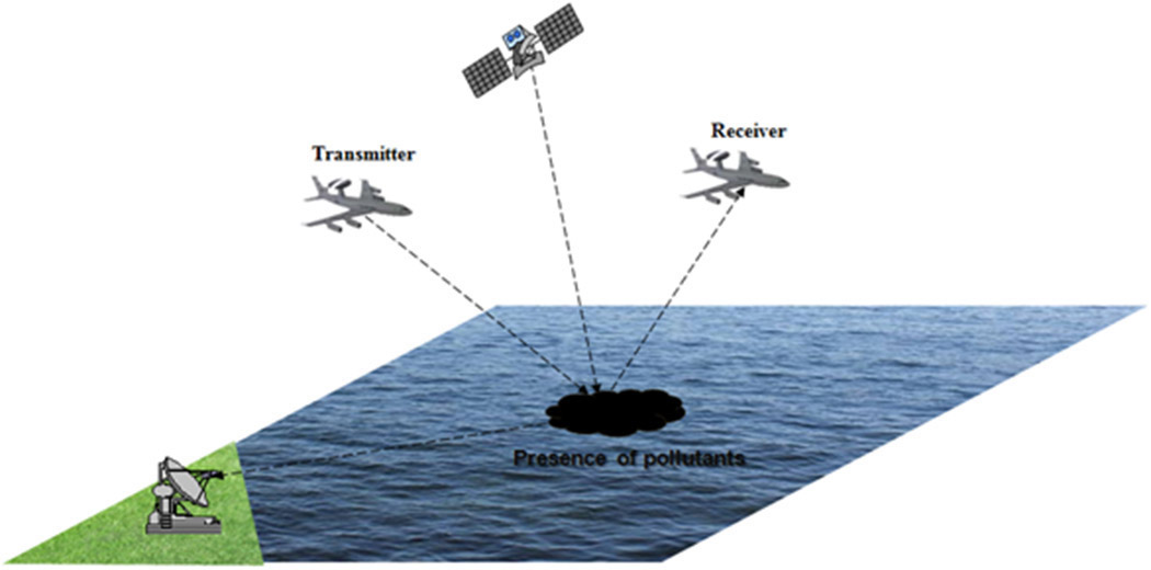
Numerical simulations reveal the effects of pollutants on bistatic electromagnetic scattering signatures.
1 September 2015, SPIE Newsroom. DOI: 10.1117/2.1201508.006108
We have numerically simulated the influence of pollutants on the characteristic EM signatures of sea surfaces. The results of our simulations show that the presence of a pollutant layer creates a large difference (about 16dB) between the scattering coefficients of clean and polluted sea surfaces. Moreover, we have observed that the maximum difference between the scattering coefficients of a clean sea surface and one that has been polluted by emulsion is on the order of 9dB. We are now planning to further develop our work by considering other comparisons and evaluations with our experimental simulation results. In particular, we will be using experimental measurements that have been obtained within the framework of the European Union's Networked Systems for Situational Awareness and Intervention in Maritime Incidents (NETMAR) project.
Related/Background:
Yan-Wei Zhao; Min Zhang; Hui Chen; Ping Zhou, "Bistatic Synthetic Aperture Radar imagery simulation of sea surface," in Microwave and Millimeter Wave Technology (ICMMT), 2010 International Conference on , vol., no., pp.1231-1234, 8-11 May 2010doi: 10.1109/ICMMT.2010.5524994
Abstract: A bistatic Synthetic Aperture Radar (Bis-SAR) imagery simulation of an extended sea surface is presented which is based on a facet scattering model. A semi-deterministic approach is developed to calculate high frequency bistatic raw data from the model of large sea surface. An effective method of modified nonlinear chirp scaling (NLCS) algorithm is presented to handle a general case of bistatic raw data and generate the simulation imagery of sea surface. This algorithm solves the inefficient problem for some time-domain algorithms and extends the limited number of bistatic cases to general for some frequency-domain methods. The concrete models and imagery results are illustrated.
keywords: {electromagnetic wave scattering;frequency-domain analysis;radar imaging;synthetic aperture radar;time-domain analysis;NLCS algorithm;bis-SAR;bistatic synthetic aperture radar imagery simulation;concrete models;facet scattering model;frequency-domain methods;modified nonlinear chirp scaling;sea surface;semideterministic approach;time-domain algorithms;Chirp;Electromagnetic scattering;Frequency;Geometry;Radar scattering;Sea surface;Synthetic aperture radar;Time domain analysis;Transmitters;Virtual reality},
URL: http://ieeexplore.ieee.org/stamp/stamp.jsp?tp=&arnumber=5524994&isnumber=5524731
Li Ying; Jin Li; Zhao Qingling, "Microwave Remote sensing sea surfaces covered in oil," in Electric Information and Control Engineering (ICEICE), 2011 International Conference on , vol., no., pp.2319-2322, 15-17 April 2011
doi: 10.1109/ICEICE.2011.5777670
Abstract: This paper presents the recent research and progress of monitoring sea surfaces covered in oil using microwave remote sensing technology. The influence of the height spectrum of a contaminated sea, by comparison with a clean sea, on the scattering coefficient has been studied. It was found that the oil slick damps the capillarity waves of the surface spectrum, implying a lower surface rms slope. A fully automated system for the identification of possible oil spills present on Synthetic Aperture Radar (SAR) satellite images based on artificial intelligence fuzzy logic has been developed. The system analyzes the satellite images and assigns the probability of a dark image shape to be an oil spill. The output consists of several images and tables providing the user with all relevant information for decision-making. A fully plarimetric electromagnetic model for sea surface Mueller matrix is exploited to characterize the scattering from oil and biogenic slicks, under low-to-moderate wind conditions. A simple and very effective filtering technique is proposed for SAR sea oil slick observation. Experiments, accomplished over C-band multilook complex SIR-CIXS AR data, show the effectivenes of the proposed model and the capabilities of the filter to both observe oil slicks and distinguish them from biogenic look-alikes. Finally the technical challenges of microwave wave Remote sensing sea surfaces covered in oil are discussed.
keywords: {artificial intelligence;capillary waves;decision making;electromagnetic wave scattering;fuzzy logic;geophysical image processing;marine pollution;oil pollution;probability;radar imaging;remote sensing by radar;surface contamination;synthetic aperture radar;C-band;Mueller matrix;SAR;artificial intelligence;biogenic slicks;capillarity waves;contaminated sea;decision making;filtering technique;fuzzy logic;height spectrum;microwave remote sensing;oil slick damps;oil spills;plarimetric electromagnetic model;probability;rms slope;satellite images;scattering coefficient;sea surface monitoring;surface spectrum;synthetic aperture radar;wind conditions;Benchmark testing;Satellites;Scattering;Sea surface;Surface cleaning;Surface contamination;Surface waves;Oil Spill;microwave radiometer;microwave remote sensing;radar scattering;synthetic aperture radar},
URL: http://ieeexplore.ieee.org/stamp/stamp.jsp?tp=&arnumber=5777670&isnumber=5776798
Zavorotny, V.U.; Voronovich, A.G., "Scattering of GPS signals from the ocean with wind remote sensing application," in Geoscience and Remote Sensing, IEEE Transactions on , vol.38, no.2, pp.951-964, Mar 2000
doi: 10.1109/36.841977
Abstract: A theoretical model that describes the power of a scattered Global Positioning System (GPS) signal as a function of geometrical and environmental parameters has been developed. This model is based on a bistatic radar equation derived using the geometric optics limit of the Kirchhoff approximation. The waveform (i.e., the time-delayed power obtained in the delay-mapping technique) depends on a wave-slope probability density function, which in turn depends on wind. Waveforms obtained for aircraft altitudes and velocities indicate that altitudes within the interval 5-15 km are the best for inferring wind speed. In some regimes, an analytical solution for the bistatic radar equation is possible. This solution allows converting trailing edges of waveforms into a set of straight lines, which could be convenient for wind retrieval. A transition to satellite altitudes, together with satellite velocities, makes the peak power reduction and the Doppler spreading effect a significant problem for wind retrieval based on the delay-mapping technique. At the same time, different time delays and different Doppler shifts of the scattered GPS signal could form relatively small spatial cells on sea surface, suggesting mapping of the wave-slope probability distribution in a synthetic-aperture-radar (SAR) fashion. This may allow more accurate measurements of wind velocity and wind direction
keywords: {atmospheric techniques;meteorological radar;radar cross-sections;radar theory;remote sensing by radar;wind;GPS signal;Global Positioning System;Kirchhoff approximation;bistatic radar;bistatic radar equation;direction;geometric optics;marine atmosphere;measurement technique;meteorological radar;radar remote sensing;radiosignal scattering;theoretical model;velocity;wave-slope probability density function;waveform;wind;wind retrieval;wind speed;Bistatic radar;Equations;Global Positioning System;Oceans;Optical scattering;Power system modeling;Radar scattering;Remote sensing;Solid modeling;Wind speed},
URL: http://ieeexplore.ieee.org/stamp/stamp.jsp?tp=&arnumber=841977&isnumber=18212
Arnold-Bos, A.; Khenchaf, A.; Martin, A., "Bistatic Radar Imaging of the Marine Environment—Part I: Theoretical Background," in Geoscience and Remote Sensing, IEEE Transactions on , vol.45, no.11, pp.3372-3383, Nov. 2007
doi: 10.1109/TGRS.2007.897436
Abstract: We describe in detail the theoretical and practical implementation aspects of a simulation for marine radars which can, in particular, be used in multistatic configurations. Since the simulator is intended to deliver pseudoraw signals, it can be used later as a tool to benchmark and improve postprocessing algorithms such as bistatic synthetic aperture radar focusing algorithms and ship wake detection algorithms. The work is divided into two parts. This paper reviews and recalls theoretical prerequisites necessary in implementing such a simulator. Included are the full derivation of the bistatic radar equation from the transmitter to the receiver, accounting also for the transmit-receive time, a description of the sea state phenomenology, a review of the theory of electromagnetic scattering from the sea surface, and the presentation and validation of the method used in the simulation. A companion paper discusses the practical implementation aspects of the simulator as well as an analysis of our results.
keywords: {backscatter;oceanographic techniques;radar clutter;radar imaging;radar theory;remote sensing by radar;synthetic aperture radar;bistatic radar equation;bistatic radar imaging;bistatic scattering;bistatic synthetic aperture radar;marine environment;marine radar;multistatic configuration;pseudoraw signals;radar receiver;radar transmitter;sea state phenomenology;sea surface electromagnetic scattering;ship wake detection algorithm;transmit-receive time;Bistatic radar;bistatic scattering;marine surveillance systems;radar simulation;synthetic aperture radar (SAR) imagery},
URL: http://ieeexplore.ieee.org/stamp/stamp.jsp?tp=&arnumber=4358851&isnumber=4373350
Haiyan Li; Perrie, W., "An analysis of the polarimetric scattering properties of oil spills on the ocean surface with hybrid polarimetry SAR," in Geoscience and Remote Sensing Symposium (IGARSS), 2013 IEEE International , vol., no., pp.302-305, 21-26 July 2013
doi: 10.1109/IGARSS.2013.6721152
Abstract: An analysis of the polarimetric scattering properties of oil-covered waters is conducted using the classic Poincaré ellipticity parameter chi (χ) from the Stokes parameters of hybrid polarized mode Synthetic Aperture Radar (SAR). For natural oil seeps, χ has a change in signs, comparing oil-covered waters with the `clean' ocean surface. The χ sign reversal is basic to sign difference oil spill detection methods. However, a problem is that oil spills related to the Deep Water Horizon (DWH) disaster did not exhibit a reversal in χ signs, when `clean' ocean surfaces are compared to the area contaminated by crude oil. Therefore, the scattering mechanism related to the oil seeps is different from that of the DWH oil spill; the former is dominated with even bounce scattering and the latter is dominated by Bragg scattering, similar to that of the clean oil-free ocean surface.
keywords: {marine pollution;oil pollution;radar polarimetry;remote sensing by radar;synthetic aperture radar;χ sign reversal;Bragg scattering;DWH disaster;Deep Water Horizon;Stokes parameters;area contamination;chi;classic Poincaré ellipticity parameter;clean ocean surface;clean oil-free ocean surface;crude oil;even bounce scattering;hybrid polarimetry SAR;hybrid polarized mode Synthetic Aperture Radar;natural oil seeps;oil spills;oil-covered waters;polarimetric scattering properties;scattering mechanism;Equations;Scattering;Sea surface;Stokes parameters;Synthetic aperture radar;Water;Poincaré ellipticity parameter;degree of polarization;hybrid polarized SAR;oil spill;polarimetric characters},
URL: http://ieeexplore.ieee.org/stamp/stamp.jsp?tp=&arnumber=6721152&isnumber=6721065
Min Zhang; Yan-Wei Zhao; Ye Zhao; Hui Chen, "A Bistatic Synthetic Aperture Radar Imagery Simulation of Maritime Scene Using the Extended Nonlinear Chirp Scaling Algorithm," in Aerospace and Electronic Systems, IEEE Transactions on , vol.49, no.3, pp.2046-2054, July 2013
doi: 10.1109/TAES.2013.6558038
Abstract: A bistatic synthetic aperture radar (Bis-SAR) imagery simulation of an extended maritime scene is presented. An efficient facet scattering model is developed to collect the raw coupling scattering data from a ship located on sea surface. Then, to avoid the inefficiency of time-domain algorithms and the azimuth-invariant limit of conventional frequency-domain (FD) methods in the bistatic case, an extended nonlinear chirp scaling (NLCS) algorithm is proposed to handle the bistatic data collected from this facet scattering model. The perfect Bis-SAR simulation results of the ship located on the sea surface could prove the validity of the proposed algorithms as well as the practicability of the model for the Bis-SAR imagery with large squint angle in the FD approach.
keywords: {chirp modulation;electromagnetic wave scattering;frequency-domain analysis;marine radar;natural scenes;radar imaging;ships;synthetic aperture radar;Bis-SAR imagery;FD approach;NLCS algorithm;bistatic collected data handling;bistatic synthetic aperture radar imagery;extended nonlinear chirp scaling algorithm;facet scattering model;frequency-domain method;maritime scene simulation;sea surface;ship;squint angle;Algorithm design and analysis;Azimuth;Marine vehicles;Scattering;Sea surface;Synthetic aperture radar;Transmitters},
URL: http://ieeexplore.ieee.org/stamp/stamp.jsp?tp=&arnumber=6558038&isnumber=6557991
Hui Chen; Min Zhang; Yan-Wei Zhao; Wei Luo, "An Efficient Slope-Deterministic Facet Model for SAR Imagery Simulation of Marine Scene," in Antennas and Propagation, IEEE Transactions on , vol.58, no.11, pp.3751-3756, Nov. 2010
doi: 10.1109/TAP.2010.2071349
Abstract: An efficient slope-deterministic facet model for the computation of the radar scattering cross section from electrically large sea surface is presented. As a facet-based theory, it is a more comprehensive model which can adequately reflect the specular and diffuse configurations, as well as the mono- and bistatic features. Significant computational efficiency and good agreement with experimental data are observed, which make the proposed facet model well suitable for fast simulation on ocean synthetic aperture radar (SAR) imagery. Base on the facet model, a hybrid scheme is developed to analyze the high frequency composite scattering from the model of a ship at sea, in which the method of equivalent currents (MEC) and a hybrid frame which combines the four path model with the quasi-image method are employed to investigate the scattering characteristics of large ship-like target and its interactions with sea surface respectively. Finally, applications to SAR imagery simulation of marine scene are discussed with the help of the proposed sea and ship-sea scattering mechanism in detail.
keywords: {deterministic algorithms;electromagnetic wave scattering;marine radar;oceanographic techniques;radar cross-sections;radar imaging;ships;synthetic aperture radar;SAR imagery simulation;efficient slope-deterministic facet model;electrical large sea surface;facet-based theory;high frequency composite scattering analysis;large ship-like target scattering characteristics;marine scene;method of equivalent currents;ocean synthetic aperture radar imagery;quasi-image method;radar scattering cross section;ship-sea scattering mechanism;Computational modeling;Marine vehicles;Numerical models;Optical surface waves;Scattering;Sea surface;Surface waves;Radar cross section;SAR imagery;sea surface electromagnetic scattering;ship and sea surface},
URL: http://ieeexplore.ieee.org/stamp/stamp.jsp?tp=&arnumber=5559368&isnumber=5617337
Arnold-Bos, A.; Khenchaf, A.; Martin, A., "Bistatic Radar Imaging of the Marine Environment—Part II: Simulation and Results Analysis," in Geoscience and Remote Sensing, IEEE Transactions on , vol.45, no.11, pp.3384-3396, Nov. 2007
doi: 10.1109/TGRS.2007.899812
Abstract: We present a bistatic, polarimetric, and real aperture marine radar simulator (MaRS) producing pseudoraw radar signals. The simulation takes the main elements of the environment into account (sea temperature, salinity, and wind speed). Realistic sea surfaces are generated using a two-scale model on a semideterministic basis to incorporate the presence of ship wakes. Then, the radar acquisition chain (antennas, modulation, and polarization) is modeled, as well as the movements of the sensors, on which uncertainties can be introduced, and ship wakes. The pseudoraw temporal signals delivered by MaRS are further processed using, for instance, bistatic synthetic aperture beamforming. The scene itself represents the sea surface as well as ship wakes. The main points covered here are the scene discretization, the ship wake modeling, and the computational cost aspects. We also present images simulated in various monostatic and bistatic configurations and discuss the results. This paper follows its companion paper, where much of the theory used here is recalled and developed in detail. a bistatic, polarimetric, and real aperture marine radar simulator (MaRS) producing pseudoraw radar signals. The simulation takes the main elements of the environment into account (sea temperature, salinity, and wind speed). Realistic sea surfaces are generated using a two-scale model on a semideterministic basis to incorporate the presence of ship wakes. Then, the radar acquisition chain (antennas, modulation, and polarization) is modeled, as well as the movements of the sensors, on which uncertainties can be introduced, and ship wakes. The pseudoraw temporal signals delivered by MaRS are further processed using, for instance, bistatic synthetic aperture beamforming. The scene itself represents the sea surface as well as ship wakes. The main points covered here are the scene discretization, the ship wake modeling, and the computational cost aspects. We also present images simulated in various- - monostatic and bistatic configurations and discuss the results. This paper follows its companion paper, where much of the theory used here is recalled and developed in detail.
keywords: {geophysical signal processing;marine radar;ocean temperature;radar imaging;radar polarimetry;wakes;wind;MaRS;antennas;bistatic radar imaging;bistatic synthetic aperture beamforming;marine environment;modulation;monostatic configurations;polarimetric real aperture marine radar simulator;polarization;pseudoraw radar signals;radar acquisition chain;salinity;sea surfaces;sea temperature;sensors movement;ship wake modeling;two-scale model;wind speed;Bistatic radar;bistatic scattering;marine surveillance systems;radar simulation;synthetic aperture radar (SAR) imagery},
URL: http://ieeexplore.ieee.org/stamp/stamp.jsp?tp=&arnumber=4358859&isnumber=4373350
Ye Zhao; Min Zhang; Yan-Wei Zhao; Xu-Pu Geng, "A Bistatic SAR Image Intensity Model for the Composite Ship–Ocean Scene," in Geoscience and Remote Sensing, IEEE Transactions on , vol.53, no.8, pp.4250-4258, Aug. 2015
doi: 10.1109/TGRS.2015.2393915
Abstract: Based on the scattering mechanisms of multipath, a bistatic synthetic aperture radar (Bis-SAR) image intensity model for the composite ship-ocean (or other metallic targets with ocean) scene is developed in this paper through reasonably dealing with the path lengths of transmitter and receiver to the ship target. To get a Bis-SAR image intensity model for the composite ship-ocean scene, the Bis-SAR image intensity distribution for the ocean surface is analyzed, and the facet scattering model is used to give the individual returns from separate facets. In addition, the influence of velocity bunching (VB) modulation of long ocean waves on the distribution of radar cross section is also discussed. Finally, Bis-SAR imagery simulations of ocean wave and the composite ship-ocean scene are illustrated, and the results show that the proposed Bis-SAR image intensity model can be reasonable and the interaction effects between the ship and sea surface can make significant contributions to the Bis-SAR intensity.
keywords: {geophysical image processing;ocean waves;synthetic aperture radar;Bis-SAR image intensity distribution;Bis-SAR image intensity model;Bis-SAR imagery simulation;Bis-SAR intensity contribution;bistatic SAR image intensity model;bistatic synthetic aperture radar image intensity model;composite ship-ocean scene;facet scattering model;long ocean wave VB modulation;long ocean wave velocity bunching modulation;metallic target;multipath scattering mechanisms;ocean surface;radar cross section distribution;receiver path length;ship target;ship-sea surface interaction effect;transmitter path length;Marine vehicles;Modulation;Ocean waves;Scattering;Sea surface;Surface waves;bistatic synthetic aperture radar (Bis-SAR) image;composite scattering;multipath;ship and sea surface},
URL: http://ieeexplore.ieee.org/stamp/stamp.jsp?tp=&arnumber=7044604&isnumber=7060793
Li, H.; Perrie, W.; He, Y.; Wu, J.; Luo, X., "Analysis of the Polarimetric SAR Scattering Properties of Oil-Covered Waters," in Selected Topics in Applied Earth Observations and Remote Sensing, IEEE Journal of , vol.PP, no.99, pp.1-9
doi: 10.1109/JSTARS.2014.2348173
Abstract: An analysis of the polarimetric scattering properties of oil-covered waters is conducted using the classic Poincaré ellipticity parameter chi (${bm {chi} }$) and the degree of polarization (${bm {m}}$) from the Stokes parameters of hybrid polarized mode synthetic aperture radar (SAR). Oil spills reduce ${bm {m}}$ for all four cases considered in this study. However, for the natural oil seep case considered, ${bm {chi} }$ has a change in signs, comparing oil-covered waters with the “clean” ocean surface. The ${bm {chi} }$ sign reversal is basic for “sign difference oil spill detection methods.” However, a problem is that the oil spill related to the deep water horizon (DWH) disaster did not exhibit a reversal in ${bm {chi} }$ signs, comparing the “clean” ocean surface to the area contaminated by crude oil. The scattering mechanism related to the oil seep is different from that of the DWH oil spill; the former is dominated with even bounce scattering and the latter is dominated by Bragg scattering, similar to that of the clean oil-free ocean surface, in the imaging area.
keywords: {Backscatter;Covariance matrices;Scattering;Sea surface;Stokes parameters;Synthetic aperture radar;Compact polarimetry;Poincaré ellipticity parameter;SAR;oil spill;stokes parameters;the degree of polarization},
URL: http://ieeexplore.ieee.org/stamp/stamp.jsp?tp=&arnumber=6942151&isnumber=4609444
Broquetas, A.; Fortes, M.; Siddique, M.A.; Duque, S.; Merlano, J.C.; Lopez-Dekker, P.; Mallorquí, J.J.; Aguasca, A., "Bistatic SAR based on Terrasar-X and ground based receivers," in Geoscience and Remote Sensing Symposium (IGARSS), 2010 IEEE International , vol., no., pp.114-117, 25-30 July 2010
doi: 10.1109/IGARSS.2010.5652966
Abstract: The paper presents the development of a ground based bistatic receiver using TerraSAR-X as a transmitter. The receiver subsystems like antennas, low-noise amplifiers, mixers, filters, synthesizers, etc. have been developed using low-cost monolithic devices in order to allow affordable deployment and at the same time offer final year students a challenging SAR engineering project. First raw data have been acquired on the Barcelona harbor area that has been focused producing geocoded images well matched with existing maps. A preliminary interferogram have been also produced.
keywords: {interferometry;radar receivers;radar transmitters;synthetic aperture radar;TerraSAR-X;bistatic SAR;ground based bistatic receiver;interferogram;low-cost monolithic devices;transmitter;Band pass filters;Gain;Low pass filters;Receivers;Resonator filters;Scattering;Sea surface},
URL: http://ieeexplore.ieee.org/stamp/stamp.jsp?tp=&arnumber=5652966&isnumber=5648802
Xiaoqing Wang; Yin Yu; Yongqiang Chen; Jiang Xiao; Minhui Zhu, "Bistatic SAR Raw Data Simulation for Ocean," in Geoscience and Remote Sensing Symposium, 2007. IGARSS 2007. IEEE International , vol., no., pp.871-874, 23-28 July 2007
doi: 10.1109/IGARSS.2007.4422935
Abstract: Bistatic SAR is a potential and effective tool for ocean remote sensing, and the simulation of bistatic SAR raw data from ocean surface plays a great role in the understanding of the mechanism of bistastic SAR ocean surface imaging. In this paper, a bistaitc SAR raw data simulation model for ocean surface is presented, which includes bistatic scattering simulation and ocean echo data simulation. In our research, based on IEM scattering model, a stochastic multiscale scattering model is improved by applying the second order nonlinear modulation model, and the speckle noise and coherent time character of ocean surface are simulated in the SAR raw data simulation.
keywords: {marine radar;radar cross-sections;remote sensing by radar;synthetic aperture radar;IEM scattering model;bistastic SAR ocean surface imaging;bistatic SAR raw data simulation model;bistatic scattering simulation;coherent time character;ocean echo data simulation;ocean remote sensing;second order nonlinear modulation model;speckle noise;stochastic multiscale scattering model;Autocorrelation;Marine technology;Oceans;Polarization;Radar scattering;Remote sensing;Sea surface;Speckle;Stochastic resonance;Synthetic aperture radar;bistatic;ocean;simulation;synthetic aperture radar (SAR)},
URL: http://ieeexplore.ieee.org/stamp/stamp.jsp?tp=&arnumber=4422935&isnumber=4422708
Yu Ying; Wang Xiaoqing; Zhu Minhui; Chong Jinsong, "Study on bistatic SAR ocean wave imaging mechanism," in Geoscience and Remote Sensing Symposium,2009 IEEE International,IGARSS 2009 , vol.2, no., pp.II-41-II-44, 12-17 July 2009
doi: 10.1109/IGARSS.2009.5417994
Abstract: In order to develop bistatic SAR ocean investigation, the first issue is the study of bistatic SAR ocean surface imaging mechanism. And velocity bunching mechanism is a SAR inherent modulation. Thus, the intensity expression in the bistatic SAR image plane is derived in this paper. The expression describes quantificationally the displacement of the scatter elements in the image plane and a degradation in radar resolution in azimuthal direction. In addition, a bistatic SAR linear velocity bunching transfer function is obtained in the linear parameter regime. Finally, this paper analyzes qualitatively the effects that various platform observation conditions have on the bistatic SAR linear imaging range of wave spectrum.
keywords: {geophysical image processing;ocean waves;radar imaging;synthetic aperture radar;SAR image plane;SAR inherent modulation;SAR linear imaging range;azimuthal direction;bistatic SAR ocean wave imaging mechanism;observation condition;radar resolution;velocity bunching mechanism;wave spectrum;Degradation;Electromagnetic scattering;Marine technology;Microwave imaging;Ocean waves;Radar imaging;Radar scattering;Sea surface;Surface waves;Transmitters;Bistatic SAR;Observation condition;Ocean;Velocity bunching},
URL: http://ieeexplore.ieee.org/stamp/stamp.jsp?tp=&arnumber=5417994&isnumber=5417981
Park, Seong-Min; Dong-Gyu, Kim; Oh, Yisok, "Numerical study of radar backscattering from sea surface contaminated by oil," in Synthetic Aperture Radar (APSAR), 2011 3rd International Asia-Pacific Conference on , vol., no., pp.1-4, 26-30 Sept. 2011
Abstract: This paper presents a numerical simulation of the radar backscattering from oil spills on ocean surfaces. This paper presents a numerical simulation of the radar backscattering from oil spills on ocean surfaces. At first, a one-dimensionally rough sea surface is numerically generated with an ocean height spectrum for a given wind velocity. A two-layered medium is generated by adding a thin oil layer on the rough sea surface. The electric fields scattered from the contaminated sea surface by oil are computed using the method of moments (MoM). Then, the backscattering coefficients are statistically obtained using N independent samples for each oil-spilled surface using the Monte Carlo technique for various conditions of surface roughness, oil-layer thickness, frequency, polarization and incidence angle. The numerical simulation results are compared with theoretical models for clean sea surfaces. The reduction of the backscattering coefficients due to oil-spills on sea surfaces has been analyzed based on numerical simulation results.
keywords: {Backscatter;Radar;Rough surfaces;Sea surface;Surface cleaning;Surface roughness;Wind speed;Method of moments;Monte Carlo technique;oil spills},
URL: http://ieeexplore.ieee.org/stamp/stamp.jsp?tp=&arnumber=6087151&isnumber=6086911
Moccia, A.; Rufino, G.; De Luca, M., "Oceanographic applications of spaceborne bistatic SAR," in Geoscience and Remote Sensing Symposium, 2003. IGARSS '03. Proceedings. 2003 IEEE International , vol.3, no., pp.1452-1454, 21-25 July 2003
doi: 10.1109/IGARSS.2003.1294141
Abstract: Not Available
keywords: {Azimuth;Electromagnetic scattering;Radar antennas;Radar imaging;Radar scattering;Rough surfaces;Sea surface;Spaceborne radar;Surface roughness;Synthetic aperture radar},
URL: http://ieeexplore.ieee.org/stamp/stamp.jsp?tp=&arnumber=1294141&isnumber=28603
Reppucci, Antonio; Marquez, Jose; Cazcarra, Victor; Ruffini, Giulio; Buck, Christopher, "A Dual-Beam Interferometric Simulator for Wavemill Instrument Assessment," in EUSAR 2014; 10th European Conference on Synthetic Aperture Radar; Proceedings of , vol., no., pp.1-4, 3-5 June 2014
Abstract: In the framework of the studies on the Wavemill concept, an End-to-End simulator has been developed in order to asses the different configurations and related sensitivity of a wide-swath interferometric SAR instrument. The simulator, being developed by Starlab under ESA contract, integrates all simulation, processing, and inversion steps involved in a real acquisition. This includes the acquisition geometry, the sea state (including swell), the sea surface scattering, the atmospheric attenuation, and the instrument configuration (including monostatic and bistatic channels). In addition, the simulator provides a SAR processing suit and a sea surface movement retrieval module. All in all, four main output products are provided: raw data (RAW), single look complex data (SLC), precision image (PRI), and sea surface movement vectors (SMV).
URL: http://ieeexplore.ieee.org/stamp/stamp.jsp?tp=&arnumber=6856918&isnumber=6856712
Ying, Yu; Anhong, Chen; Xingli, Huang; Minhui, Zhu, "Study on radar imaging simulation of ocean current and waves," in Synthetic Aperture Radar (APSAR), 2011 3rd International Asia-Pacific Conference on , vol., no., pp.1-4, 26-30 Sept. 2011
Abstract: Monitoring ocean surface current is one of the most important applications for microwave remote sensing. It is significant for both civil and martial maritime activities. Microwave sensors mainly include early RAR, high-resolution SAR, and Bistatic SAR which is newly arisen[1]. A simulation procedure for RAR/SAR/biSAR with parallel flight squint mode imagery of ocean surface distributed targets is presented in this paper. With the use of ocean surface current file, sea state and radar parameters, and take tilt, hydrodynamic and velocity bunching modulation into account, this procedure can generate simulated radar imagery, based on the ocean surface scattering model and radar echo model. Radar imagery generated by this procedure can provide simulated data source for sequent algorithms research, i.e., ocean targets detection.
keywords: {Imaging;Modulation;Oceans;Radar imaging;Radar scattering},
URL: http://ieeexplore.ieee.org/stamp/stamp.jsp?tp=&arnumber=6087164&isnumber=6086911
Xie Tao; Binhong Li; WenJun Chen; Yijun He, "The scattering fields of 2-D sea fractal surface with finite conductivity illuminated by ellipse polarization wave. Part One. Scattering fields in Cartesian coordinates," in Geoscience and Remote Sensing Symposium, 2004. IGARSS '04. Proceedings. 2004 IEEE International , vol.4, no., pp.2772-2775 vol.4, 20-24 Sept. 2004
doi: 10.1109/IGARSS.2004.1369877
Abstract: Recently, many analytical expressions of scattering fields of sea fractal surface with infinite conductivity were derived. In order to simulate multi-polarization SAR imaging of sea surface and consider the effects of polarization on remote sensing of sea surface, we derive the scattering fields from 2D sea fractal surface with finite conductivity illuminated by ellipse polarization wave at Kirchhoff approximation. Then we present the scattering matrix of this model and numerically simulate the bistatic radar cross section (RCS) of 2D sea fractal surface. It shows that the result of applying our model coincides with that of relevant literatures. Our work is divided into two parts. In the first part, we derive the scattering fields in Cartesian coordinates. And in the second part, we evaluate the scattering matrix of this model and then give the numerical results and discuss them.
keywords: {backscatter;data acquisition;geophysical signal processing;oceanographic techniques;oceanography;radar cross-sections;radar signal processing;remote sensing by radar;synthetic aperture radar;2D sea fractal surface scattering field;Cartesian coordinates;Kirchhoff approximation;bistatic radar cross section;ellipse polarization wave;finite conductivity;multipolarization SAR imaging;remote sensing;scattering matrix;Conductivity;Fractals;Kirchhoff's Law;Numerical models;Polarization;Radar polarimetry;Radar scattering;Remote sensing;Sea surface;Surface waves},
URL: http://ieeexplore.ieee.org/stamp/stamp.jsp?tp=&arnumber=1369877&isnumber=29947
Duk-jin Kim; Jinho Kang; Boyeol Yoon; Younsoo Kim; Yongseung Kim, "Observation of Crude Oil Spill Off the West Coast of Korea using TerraSAR-X, ENVISAT ASAR and ALOS PALSAR," in Geoscience and Remote Sensing Symposium, 2008. IGARSS 2008. IEEE International , vol.3, no., pp.III - 1398-III - 1401, 7-11 July 2008
doi: 10.1109/IGARSS.2008.4779622
Abstract: On December 7th, 2007, more than 10,000 tons of crude oil from a tanker leaked into the Yellow Sea off the west coast of Korean Peninsula. Several SAR images including TerraSAR-X, ENVISAT ASAR, RADARSAT-1, ERS-2 SAR and ALOS PALSAR were acquired over the contaminated area from oil spill. Observed dark patches in SAR images, due to the presence of oil slicks, were extracted using adaptive thresholding methods, and then classified based on field information. The damping ratio, which is a ratio between slick-free and slick-covered sea surface, was analyzed by the SAR radar frequencies and wind condition. With the acquired SAR images in temporal resolutions, the movement of oil slicks was monitored and traced.
keywords: {image processing;oceanography;remote sensing by radar;synthetic aperture radar;wind;ALOS PALSAR image;ENVISAT ASAR image;ERS-2 SAR image;Korean Peninsula;RADARSAT-1 image;TerraSAR-X image;Yellow Sea;adaptive thresholding methods;contaminated area;crude oil spill observation;field information;image acquisition;observed dark patches;oil slicks;oil slicks movement;slick-free/slick-covered sea surface ratio;tanker leak;temporal resolutions;wind condition;Ocean temperature;Petroleum;Radar cross section;Radar imaging;Radar scattering;Remote sensing;Sea surface;Surface waves;Synthetic aperture radar;Wind;Heibei Spirit;Oil spill;SAR;Yellow Sea},
URL: http://ieeexplore.ieee.org/stamp/stamp.jsp?tp=&arnumber=4779622&isnumber=4779256
Min Zhang; Hui Chen; Hong-Cheng Yin, "Facet-Based Investigation on EM Scattering From Electrically Large Sea Surface With Two-Scale Profiles: Theoretical Model," in Geoscience and Remote Sensing, IEEE Transactions on , vol.49, no.6, pp.1967-1975, June 2011
doi: 10.1109/TGRS.2010.2099662
Abstract: This paper is aimed at developing an applicable and feasible facet model, which formulation should be tractable and time saving for personal computers to take charge of the efficient evaluation on the complex reflective function of large-scope 2-D oceans, either in the monostatic or bistatic case. The sea surface is envisaged as a two-scale profile on which the long waves are locally approximated by planar facets. The microscopic profile within a facet is assumed to be represented by a set of sinusoidal ripple patches. The complex reflective function of each modified facet is evaluated by a modified formula of the original Bass and Fuks' two-scale model, in which the phase factor of each facet is with the capillary wave modification. Several examples with application to the frozen or time-evolving case are given to prove the implementation.
keywords: {atmospheric electromagnetic wave propagation;electromagnetic wave reflection;electromagnetic wave scattering;marine radar;oceanographic techniques;remote sensing by radar;synthetic aperture radar;Bass and Fuks two-scale model;bistatic case;capillary wave modification;complex reflective function;electrically large sea surface;electromagnetic wave scattering;facet-based investigation;large-scope 2D oceans;microscopic profile;monostatic case;sinusoidal ripple patches;two-scale profiles;Backscatter;Computational modeling;Decorrelation;Scattering;Sea surface;Surface waves;Electromagnetic scattering;facet-based model;time-evolving sea surfaces},
URL: http://ieeexplore.ieee.org/stamp/stamp.jsp?tp=&arnumber=5702364&isnumber=5770378
Pereslegin, Sergei; Khalikov, Zaur; Kovalenko, Alexander, "Bistatic quasi-mirror radar of the sea surface from space: Properties and prospects," in Synthetic Aperture Radar, 2012. EUSAR. 9th European Conference on , vol., no., pp.776-779, 23-26 April 2012
Abstract: The main properties of a bistatic quasi-mirror radar of the sea surface are considered in an approximation of quasi-mirror scattering from isotropic surface waves. Surface-wave scattering diagrams determining the radar energetic and width of the radar survey area, are calculated under horizontal polarization and arbitrary fall angles. The follow factors are considered: the form of ‘flare track’, across resolution, ground range scale extensive, frequency separate of survey zones and measuring possibilities of interferometer that's placed on the receiving vehicle.
keywords: {Mirrors;Radar;Scattering;Sea surface;Surface waves;Vehicles;Wind speed},
URL: http://ieeexplore.ieee.org/stamp/stamp.jsp?tp=&arnumber=6217186&isnumber=6215928
Lindgren, T.; Akos, D.M., "A Multistatic GNSS Synthetic Aperture Radar for Surface Characterization," in Geoscience and Remote Sensing, IEEE Transactions on , vol.46, no.8, pp.2249-2253, Aug. 2008
doi: 10.1109/TGRS.2008.917268
Abstract: Bistatic global navigation satellite system (GNSS) radar has received increased attention in recent years within both the radar and GNSS communities. In this paper, the traditional bistatic GNSS radar and bistatic synthetic aperture radar (SAR) concepts are fused into a more generic multistatic GNSS SAR system for surface characterization. This is done by using the range and Doppler processing techniques on signals transmitted by multiple satellites to determine the angular dependence of the surface reflectivity. The method has also been tested experimentally, and the results are presented.
keywords: {Doppler radar;geophysical signal processing;remote sensing by radar;spaceborne radar;synthetic aperture radar;terrain mapping;vegetation mapping;Doppler processing technique;angular dependence;bistatic global navigation satellite system radar;bistatic synthetic aperture radar;multistatic GNSS synthetic aperture radar;range processing technique;surface characterization;surface reflectivity;Doppler radar;Global Positioning System;Radar detection;Radar scattering;Reflection;Satellite broadcasting;Satellite navigation systems;Sea surface;Spaceborne radar;Synthetic aperture radar;Global positioning system (GPS);radar measurements},
URL: http://ieeexplore.ieee.org/stamp/stamp.jsp?tp=&arnumber=4578825&isnumber=4578813
[Title page]," in Geoscience and Remote Sensing Symposium,2009 IEEE International,IGARSS 2009 , vol.1, no., pp.i-i, 12-17 July 2009
doi: 10.1109/IGARSS.2009.5416877
Abstract: The following topics are discussed: data processing and management; geological applications; optical modeling and inversion; Sentinel-1; bistatic SAR; hyperspectral sensing; Africa; forest resources; satellite sensor synergy; ocean surface wind; water observation system; ocean surface scattering; TRMM; GPM; NPOESS; marine ecosystems; sea surface temperature; ALOS; TerraSAR-X; landmine detection; target and object detection; microwave remote sensing; microwave radiometry; GNSS; savanna process and dynamics; volume scattering; ocean colour; hyperspectral image classification; feature extraction; lidar sensing; ocean biology; atmospheric sensing, aerosols and chemistry; UAV and airborne sensing; land surface snow and ice; geospatial analysis; electromagnetics and radiative transfer; RADARSAT; TANDEM-X; COSMO-SKYMED mission; Envisat Earth observations; radar interferometry; data assimilation; water quality; soil moisture retrieval; glaciers; polarimetric information extraction; geomorphology; active tectonics; Soil Moisture Ocean Salinity mission; sea ice; human health and landscape epidemiology; and ocean waves.
keywords: {aerosols;artificial satellites;atmospheric chemistry;atmospheric techniques;data assimilation;feature extraction;forestry;geomorphology;geophysical image processing;glaciology;hydrological techniques;ice;image classification;landmine detection;ocean temperature;ocean waves;oceanographic techniques;radar polarimetry;radiative transfer;radiometry;remote sensing by laser beam;remote sensing by radar;sea ice;snow;soil;synthetic aperture radar;tectonics;terrain mapping;vegetation mapping;wind;ALOS;Africa;COSMO-SKYMED mission;Envisat Earth observation;GNSS;GPM;NPOESS;RADARSAT;Sentinel-1;Soil Moisture Ocean Salinity mission;TANDEM-X;TRMM;TerraSAR-X;UAV;active tectonics;aerosols;airborne sensing;atmospheric chemistry;atmospheric sensing;bistatic SAR;data assimilation;data management;data processing;electromagnetics;feature extraction;forest resources;geological applications;geomorphology;geospatial analysis;glaciers;human health;hyperspectral image classification;hyperspectral sensing;land surface snow;landmine detection;landscape epidemiology;lidar sensing;marine ecosystems;microwave radiometry;microwave remote sensing;object detection;ocean biology;ocean colour;ocean surface scattering;ocean surface wind;ocean waves;optical inversion;optical modeling;polarimetric information extraction;radar interferometry;radiative transfer;satellite sensor synergy;savanna dynamics;savanna process;sea ice;sea surface temperature;soil moisture retrieval;target detection;volume scattering;water observation system;water quality},
URL: http://ieeexplore.ieee.org/stamp/stamp.jsp?tp=&arnumber=5416877&isnumber=5416731
IEEE Standard Radar Definitions," in IEEE Std 686-1997 , vol., no., pp.i-, 1998
doi: 10.1109/IEEESTD.1998.86185
Abstract: Definitions for the purpose of promoting clarity and consistency in the use of radar terminology are provided. The definitions represent the consensus of a panel of radar experts.
keywords: {radar;IEEE standard radar definitions;radar terminology;Radar},
URL: http://ieeexplore.ieee.org/stamp/stamp.jsp?tp=&arnumber=661546&isnumber=14472
Eibert, T.F.; Buddendick, H., "Direct image formation with current distributions generated by shooting and bouncing rays," in Computational Electromagnetics International Workshop (CEM), 2011 , vol., no., pp.38-38, 10-13 Aug. 2011
doi: 10.1109/CEM.2011.6047325
Abstract: Summary form only given. Image formation by inverse synthetic aperture radar (ISAR) methods is one of the most advanced approaches to explore the scattering or radiation properties of a finite sized object. ISAR imaging is based on the coherent processing of radar signals, which are collected for a range of observation angles and for a certain range of frequencies. In a radar experiment, it is mandatory that ISAR works with the waves scattered from the observed object. In contrast, in simulation based considerations there is no need to compute the scattered waves explicitly. It is rather recommended to directly generate the ISAR image with the induced currents on the targets, which are usually available in an electromagnetic simulation, e.g., by the shooting and bouncing rays (SBR) techniques utilizing physical optics (PO). Instead of computing the scattered or radiated fields from the real or equivalent currents the radiation integral is directly inserted into the imaging integral and by interchanging the integration orders, the imaging point spread function can be generated. Consequently, the image formation is reduced to a convolution of the found point spread function with the current distribution. A concise vectorial formulation of this well-known methodology is presented together with a discussion of important properties. The general case of 3-D ISAR imaging is considered, which is also specialized to the 2-D situation. The point spread functions are analytically derived for narrow angle and narrow bandwidth imaging, where a bistatic observation range symmetrically arranged around one incident direction is considered. The resulting images can thus be assumed as a good approximation of monostatic images, which are often desired. Various examples of 2-D and 3-D images for complex metallic objects such as automobiles are shown, which have been obtained from the surface currents of an SBR field solver. Implementation issues related to the required interpolations a- - s well as the efficient realization of the SBR simulations are discussed.
keywords: {current distribution;interpolation;radar imaging;synthetic aperture radar;3D ISAR imaging;3D inverse synthetic aperture radar imaging;PO;SBR field solver;SBR technique;bistatic observation range symmetry;complex metallic object;current distribution;electromagnetic simulation;finite sized object;image formation;imaging integral;imaging point spread function;interpolation;monostatic image approximation;narrow angle imaging;narrow bandwidth imaging;observation angle ranging;physical optics;radar signal processing;radiation integral;radiation property;shooting and bouncing ray technique;wave scattering property;Computational modeling;Current distribution;Electromagnetics;Imaging;Interpolation;Radar imaging},
URL: http://ieeexplore.ieee.org/stamp/stamp.jsp?tp=&arnumber=6047325&isnumber=6047317
Ghanmi, H.; Khenchaf, A.; Comblet, F., "Numerical simulation of bistatic electromagnetic scattering by contaminated sea surface," in Radar Conference (Radar), 2014 International , vol., no., pp.1-4, 13-17 Oct. 2014
doi: 10.1109/RADAR.2014.7060310
Abstract: The aim of this paper is to study the influence of the pollutants (oil spills) on the electromagnetic signature of sea surface observed in bistatic configuration. Therefore, we will start the numerical analyses of the pollutants influence on the sea surface roughness. Then, we will evaluate the electromagnetic scattering coefficients of the contaminated sea surface (sea surface covered by oil layer) in bistatic case by using the numerical Forward-Backward Method (FBM). The model used for the numerical simulation of bistatic scattering coefficients of clean and contaminated sea surface has been analyzed as a function of various parameters (sea state, type of pollutant, incidence and observation angles, radar frequency and polarizations).
keywords: {marine pollution;numerical analysis;oceanographic regions;oil pollution;bistatic configuration;bistatic electromagnetic scattering coefficients;contaminated sea surface electromagnetic signature;numerical forward-backward method;numerical simulation;oil layer;pollutant type;pollutants influence;radar frequency;sea state parameter;sea surface roughness;Electromagnetic scattering;Rough surfaces;Sea surface;Surface cleaning;Surface contamination;Surface roughness;bistatic configuration;electromagnetic scattering coefficients;forward-backward method;oil spills;polarizations;radar frequencies;sea surface},
URL: http://ieeexplore.ieee.org/stamp/stamp.jsp?tp=&arnumber=7060310&isnumber=7060235
Helmi, Ghanmi; Ali, Khenchaf; Fabrice, Comblet, "Modeling of bistatic EM scattering by polluted sea surface using asymptotic and rigorous methods," in Radar Symposium (IRS), 2015 16th International , vol., no., pp.1021-1026, 24-26 June 2015
doi: 10.1109/IRS.2015.7226362
Abstract: This paper presents the study and analysis of the bistatic electromagnetic (EM) signature variation of the sea surface contaminated by pollutants. Therefore, we start with the numerical analysis the effect of the presence of the pollutant on the sea surface characteristics. Then, we evaluate the EM scattering coefficients of the clean and polluted sea observed in bistatic configuration by using the rigorous Forward-Backward Method (FBM) and the asymptotic Two Scale Model (TSM). The obtained numerical results of the EM scattering coefficients are studied and given as a function of various parameters: sea state, type of pollutant, incident and observation angles, frequencies and radar polarization.
keywords: {Petroleum;Rough surfaces;Scattering;Sea surface;Surface cleaning;Surface contamination;Surface roughness},
URL: http://ieeexplore.ieee.org/stamp/stamp.jsp?tp=&arnumber=7226362&isnumber=7226207
Pinel, N.; Bourlier, C.; Dechamps, N., "Spectrum of rough sea surfaces covered in oil: Consequences on the radar cross section," in Microwave Conference, 2007. European , vol., no., pp.1546-1549, 9-12 Oct. 2007
doi: 10.1109/EUMC.2007.4405502
Abstract: This paper describes the influence of oil pollution over sea surfaces on the height spectrum of the rough surfaces. An oil slick damps the capillarity waves of the surface height spectrum, and reduces the RMS slope of the surface. These modified functions have then an influence on the radar cross section from contaminated sea surfaces. The impact of the contaminated sea surface on the bistatic radar cross section is then presented.
keywords: {approximation theory;capillarity;electromagnetic wave scattering;oil pollution;radar cross-sections;statistical analysis;bistatic radar cross section;capillarity waves;contaminated sea surfaces;modified functions;oil pollution;oil slick;rough sea surfaces;surface height spectrum;Autocorrelation;Permittivity;Petroleum;Radar cross section;Rough surfaces;Sea surface;Surface cleaning;Surface contamination;Surface roughness;Surface waves},
URL: http://ieeexplore.ieee.org/stamp/stamp.jsp?tp=&arnumber=4405502&isnumber=4405082
Pinel, N.; Bourlier, C., "Modeling of Height Spectrum and Radar Cross Section of Oil Slicks on Sea Surfaces," in Geoscience and Remote Sensing Symposium, 2008. IGARSS 2008. IEEE International , vol.4, no., pp.IV - 1129-IV - 1132, 7-11 July 2008
doi: 10.1109/IGARSS.2008.4779926
Abstract: The influence of oil pollution over sea surfaces on the height spectrum of rough surfaces is studied. An oil slick covering the sea damps the capillarity waves of the surface height spectrum and reduces the root mean square slope of the surfaces. These modifications have an influence on the normalized radar cross section (NRCS) of contaminated seas. The bistatic NRCS of the contaminated sea surface is then persented by comparison with a clean sea: results from a benchmark numerical model are presented and compared with a new semi-empirical approach using asymptotic models, like the weighted curvature approximation.
keywords: {ocean waves;oceanographic techniques;oil pollution;radar cross-sections;remote sensing by radar;water pollution;capillarity waves;contaminated sea surface bistatic NRCS;height spectrum modeling;normalized radar cross section;oil pollution;radar cross section modeling;rough surface height spectrum;sea surface oil slicks;weighted curvature approximation;Oil pollution;Petroleum;Radar cross section;Root mean square;Rough surfaces;Sea surface;Surface cleaning;Surface contamination;Surface roughness;Surface waves;Electromagnetic scattering by rough surfaces;Multistatic scattering;Random media;Sea surface;Water pollution},
URL: http://ieeexplore.ieee.org/stamp/stamp.jsp?tp=&arnumber=4779926&isnumber=4779630
Pinel, N.; Dechamps, N.; Bourlier, C., "Modeling of the Bistatic Electromagnetic Scattering From Sea Surfaces Covered in Oil for Microwave Applications," in Geoscience and Remote Sensing, IEEE Transactions on , vol.46, no.2, pp.385-392, Febuary 2008
doi: 10.1109/TGRS.2007.902412
Abstract: This paper describes the influence of oil pollution over sea surfaces on the height spectrum and the height autocorrelation function of rough surfaces. An oil slick damps the capillarity waves of the surface height spectrum and reduces the root mean square slope of the surface. These modified functions then have an influence on the radar cross section (RCS) from contaminated sea surfaces. The bistatic RCS of the contaminated sea surface is then presented by comparison with a clean sea: results from a benchmark numerical model are presented and compared with a new semiempirical model using the geometric optics approximation and then the first-order smallslope approximation.
keywords: {marine pollution;oceanography;oil pollution;radar cross-sections;bistatic electromagnetic scattering modeling;capillarity waves;first-order smallslope approximation;geometric optics approximation;height autocorrelation function;microwave applications;oil pollution;oil slick;radar cross section;root mean square slope;rough sea surfaces;semiempirical model;surface height spectrum;Electromagnetic modeling;Electromagnetic scattering;Optical surface waves;Petroleum;Rough surfaces;Sea surface;Surface cleaning;Surface contamination;Surface roughness;Surface waves;Ocean remote sensing;radar scattering;scattering by rough surfaces;sea surface},
URL: http://ieeexplore.ieee.org/stamp/stamp.jsp?tp=&arnumber=4410505&isnumber=4432701
Pinel, N.; Bourlier, C., "Modeling of radar scattering from oil films," in Radar Conference - Surveillance for a Safer World, 2009. RADAR. International , vol., no., pp.1-5, 12-16 Oct. 2009
Abstract: Oil films on the sea surface damp the capillary waves of the surface height spectrum. This hydrodynamic damping influences the normalized radar cross section (NRCS) of contaminated seas, comparatively to clean seas. First, a simple appropriate damping model is presented with parameters that match experimental results. Second, the two-dimensional bistatic NRCS of the contaminated sea surface is presented by comparison with that of a clean sea.
keywords: {capillary waves;electromagnetic wave scattering;radar cross-sections;random media;capillary waves;contaminated sea surface;hydrodynamic damping;normalized radar cross section;oil films;radar scattering;Damping;Hydrodynamics;Petroleum;Radar cross section;Radar scattering;Rough surfaces;Sea surface;Surface cleaning;Surface contamination;Surface roughness;Electromagnetic scattering by rough surfaces;Multistatic scattering;Random media;Sea surface;Water pollution},
URL: http://ieeexplore.ieee.org/stamp/stamp.jsp?tp=&arnumber=5438508&isnumber=5438351
No comments:
Post a Comment