Satellite Communications a critical capability for large UAVs
UAV Data-Links: Tasks, Types, Technologies and Examples p010757.pdf |
| Northrop Grumman RQ-4C |
The growing use of unmanned aerial vehicles (UAVs), like Predator and Global Hawk aircraft, is making military communications satellite bandwidth a vital part of national military infrastructure. The remote piloting of UAVs, sometimes from thousands of miles away, and employment of UAV-carried sensors and weapons, make satcom bandwidth as vital for these unmanned aircraft operations as the fuel that powers their engines.
Space capabilities such as GPS and SATCOM have been key to the evolution of UAVs. While smaller tactical UAVs use line of sight RF links for control and sensor access, SATCOM has been a key enabler for UAVs such as the Northrop Grumman Global Hawk RQ-4 and the General Atomics ASI MQ-1 Predator and Reaper. This has enabled operators in the Nevada desert to control and conduct UAV operations in Iraq and Afghanistan. SATCOM will continue to evolve with the next generation of UAVs such as Zephyr.
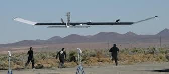
Zephyr 7 High Altitude Pseudo-Satellite,
Airbus’s high-altitude pseudo-satellite Zephyr 8 programme moves ahead - Aerospace TechnologyAirbus invites partners to test mission payloads with Zephyr 8 ‘Pseudo-Satellite’ | Defense Update:
Running exclusively on solar power and flying at high altitudes above the weather and above commercial air traffic, Zephyr 8 will bridge the gap between satellites and UAVs. Unlike reconnaissance satellites that monitor the earth surface from low-earth orbit, these HAPS will be able to persist over an area of interest providing satellite-like communications and intelligence, surveillance and reconnaissance (ISR) services without interruption. Through these evaluations Airbus’ Zephyr team is ready to help customers design, build and operate the mission payloads, or provide the necessary interface to integrate those payloads in upcoming test flights.Although the type of SATCOM link used was not reported, Ka band, with its lower weight and smaller antenna, and the wider bandwidth would be a logical choice for the Zephyr platform. The high altitude operation and very stable dynamics would mitigate Ka band limitations. Zephyr HAPS could serve as a bridge for Ku band MALE UAVs to connect to wideband Ka band satellite networks.
The test of the Zephyr 7 High Altitude Pseudo-Satellite, or HAPS, was conducted for Britain's Ministry of Defense in controlled airspace, the company said.Satellite used to control unmanned aerial vehicle - UPI.com
The aircraft carried a new primary payload and for the first time satellite communications were used to control and monitor the aircraft.
"The use of the SatCom link to control the aircraft beyond line-of-sight of the ground station is another critical aspect that we needed to test to move towards a pseudo-satellite form of operation where the Zephyrs can be controlled across the world from a central control station," said Jens Federhen, head of the Airbus HAPS program.
The Zephyr aircraft was developed by the British company QinetiQ and is now part of Airbus' HAPS program. The Zephyr 7 has a wingspan of nearly 74 feet and a weight of nearly 118 pounds when carrying a 5 pound payload. It's service ceiling is more than 70,000 feet.
Pseudo-satellites: The west wind blows afresh | The Economist
Airbus completes winter testing of Zephyr 7 in Southern Hemisphere - Airforce Technology
SATELLITE USED TO CONTROL UNMANNED AERIAL VEHICLE | Article - Thu 28 Aug 2014 07:39:54 PM UTC | airsoc.com, reach for the sky.
Current MALE and HALE UAV useage
MQ-1 Predator Unmanned Aerial Vehicle - Remote Piloted Aircraft (RPA)
The Predator uses unencrypted "bent pipe" commercial satellite links. The satellite terminal antenna dish shown below is installed inside the forward upward bulge where the cockpit might be in a manned platform. The dish must point and track a selected Ku band Geosat. This restricts maneuverability and attitude of the aircraft. Since the GeoSat is located in the equatorial geosynchronous orbit, high latitude operations are restricted.The Predator can run autonomously, executing simple missions such as reconnaissance on a program, or it can run under the control of a crew. The crew of a single Predator UAV consists of one pilot and two sensor operators. The pilot drives the aircraft using a standard flight stick and associated controls that transmit commands over a C-Band line-of-sight data link. When operations are beyond the range of the C-Band, a Ku-Band satellite link is used to relay commands and responses between a satellite and the aircraft [with some delay]. Onboard, the aircraft receives orders via an L-3 Com satellite data link system. The pilots and crews use the images and radar received from the aircraft to make decisions about controlling the plane.
 |
| Predator UAV Terminal |

The Predator Reconnaissance Communications System (w. ATC Radio) will include:
- Predator UAV, fully equipped with sensors and ATC Radio and Ku SDL, and LOS data link (within UAV operating range of launching and maintenance facilities).
- Transponder lease(s) on appropriately positioned commercial, Ku-band geosynchronous satellites. Lease, revenue arrangements and spot beam locations all established long before mission initiation.
- In-theater exploitation and control complex, including transportable satellite earth terminal (IESS-208, Type E2) with full duplex Ku-band receive and transmit capability. Complex would include exploitation capability and full connectivity to in theater voice communications complex. Remote pilot (GCS) accomplishes ATC with authorities near flight-path via data links and onboard AN/ARC-210 radio
- HowStuffWorks "How the Predator UAV Works"
How the Predator UAV Works
Ku-band_SATCOM_Data-Link_(KuSDL)_Predator_Sales-Sheet_WEB.pdf


Which band satellite to use Ka, or Ku
Ka-Band vs. Ku-Band - What's Better? | Fact CheckSatMagazine - Is Ka-Band The Ku- Killer?
the major talking point when it comes to connectivity on the move surrounds coming Ka-band capacity, which was, and probably still is, widely-perceived to be a Ku- killer.
Demand Grows for Broadband SATCOM Links to and From Aircraft | Defense News | defensenews.com

Test Data Indicate Possible Ka-band Weakness for UAV Links | SpaceNews.com
PARIS — Ongoing tests using military Ka-band satellite links to a ground terminal simulating an unmanned aerial vehicle (UAV) raise questions about how much bandwidth can be offloaded from UAVs flying below even mild cloud cover on otherwise sunny days, Astrium Services has concluded.“This whole nirvana you hear about massive data rates — well, show us what tests you’ve done,” said Dylan Browne, Astrium Services vice president for sales and marketing. “What we have found so far is a tough reality: Some customers will have to be kicked off the satellite link because of changed priorities in the military command at a time when bandwidth is not available.”
Astrium Services is using 10 megahertz of civil Ka-band frequency converted to the neighboring military Ka-band frequency aboard the Hylas-1 telecommunications satellite. Hylas-1, which was launched in November and declared ready for service in March, was designed to test this kind of payload flexibility.
Astrium’s preliminary conclusions are that the pitch and roll of UAVs combined with even intermittent clouds or dust concentrations could pose challenges for the use of Ka-band in conflict areas.
Satellite Service Ku Band Coverage Maps
NSS-6 Ku band coverage
In a presentation here to the MilSpace 2011 conference organized by SMi Group of London, Browne said the company is well aware that Ku-band has become too popular over the Middle East, South Asia and North Africa to permit much growth in UAV data links using that frequency.
With Ku-band satellites now spaced 2 degrees apart in geostationary orbit, rather than the previous standard of 4 degrees, a 1-meter, 16-watt antenna on a UAV transmitting at 10 megabits per second or more is likely to interfere with other satellites in the region. It is one of several reasons for the migration to Ka-band.
The U.S. Department of Defense and other military organizations are planning the gradual rollout of Ka-band capabilities in the coming years, notably the Warfighter Information Network-Tactical (WIN-T) terminals using the Wideband Global Satcom system’s Ka-band links.
Startup satellite operator Yahsat of the United Arab Emirates has a sizable amount of Ka-band satellite capacity being readied for government use, and London-based Inmarsat is building three large Ka-band satellites for near-global coverage for military and corporate customers.
.jpg)
No comments:
Post a Comment