In 1901, steamer ship City of Rio de Janeiro sank
on its way into the San Francisco Bay, killing 128 passengers and
disappearing into the ocean. The famous lost ship stayed disappeared for
over 100 years, its location suspected but never confirmed. Now, thanks to a sonar technology called "Echoscope," scientists have pinpointed the wreck's location, and created a 3D map of the briny remains.
An archeological expedition led by the Office of National Marine Sanctuaries Maritime Heritage Program this past November used an Echoscope
and a remote vehicle to trawl the bottom of the ocean. When they
finally discovered the ship around 287 feet below the surface, there
wasn't much left. Just "a crumpled, scarcely recognizable iron hulk
encased in more than a century worth of mud and sediment," according to
the agency's report. But the sonar technology and 3D images it produced
illuminated for researchers how the City of Rio sank; the way the ship is positioned indicates that it went down too quickly for most passengers to escape.
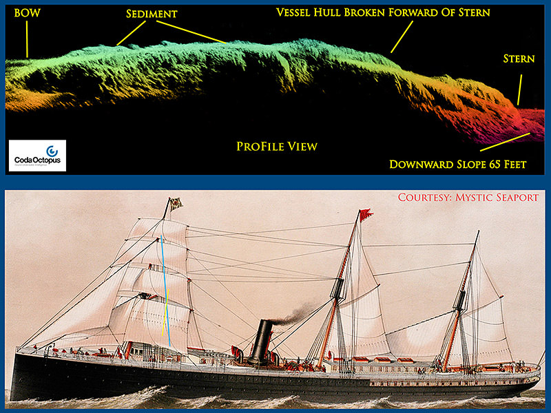 |
| Top - CodaOctopus 3-D Echoscope sonar profile view of SS City of Rio De Janeiro. Credit: Coda Octopus/NOAA Bottom - Painting of SS City of Rio De Janeiro. Credit: Mystic Seaport |
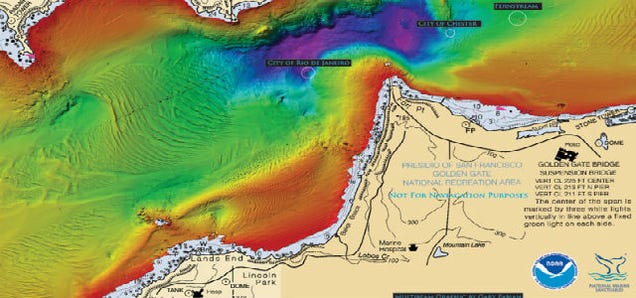
NOAA and partners today released three-dimensional sonar maps and images of an immigrant steamship lost more than 100 years ago in what many consider the worst maritime disaster in San Francisco history.
On Feb. 22, 1901, in a dense morning fog, the SS City of Rio de Janeiro struck jagged rocks near the Golden Gate Bridge and sank almost immediately, killing 128 of the 210 passengers and crew aboard the ship.

By generating over 16,000 beams per acoustic transmission and with a frame rate of over 10 pings per second, Echoscope® sonars provide unique underwater 3D acoustic movie imagery. Viewing the subsea scene in real time using patented 3D rendering techniques allows for immediate decision making during underwater positioning projects, whilst maintaining a measureable dataset for mapping purposes.
Used in a number of applications ranging from Port Security, IRM (Inspection, Repair and Maintenance), and cable or mattress laying through to marine construction and ROV intervention work, the Echoscope has proved to save vessel time and increase productivity during zero visibility subsea conditions.
Compact and portable and with the choice of either single frequency or dual frequency systems, the Echoscope can be rapidly deployed on vessels using an over-the-side pole mount or alternatively integrated onto a number of different ROVs or AUVs.
Each Echoscope 3D sonar is supplied with the modular USE (Underwater Survey Explorer) topside software package which can integrate the sonar to a number of auxiliary sensors like motion, heading and positioning systems.
The combination of Echoscope and USE software with their unique and patented capabilities is changing the mode of many subsea operations around the globe.
Published on Oct 19, 2012
Inspection
of the wreck "Integrity" located in a water depth of approximately 40
metres in the Firth of Forth, Scotland, UK. Using Echoscope-UIS
software, the real-time 3D image can be switched with an above-water
camera view, a 2D view or a chart overview.
No comments:
Post a Comment