 |
| Gaofen-3 Mockup - The SAR package featuring a large radar antenna 18 m in length |
 |
| Tracking data published by the U.S. military’s Joint Space Operations Center indicated the Long March 4C rocket placed the Gaofen 3 satellite into orbit at an altitude of nearly 460 miles (740 kilometers). The craft is circling Earth at an inclination of 98.4 degrees to the equator. |
Designed by CAST (China Academy of Space Technology), Gaofen-3 employs the CS-L3000B bus configured with multi-polarized C-band SAR at meter-level resolution. Development of the new satellite was initiated in December 2010, with the engineering development beginning in September 2013. The satellite was completed in March 2016. The new satellite has a designed lifespan of eight years and will mainly be used by the State Oceanic Administration (SOA) of China.
China Launches SAR Satellite Capable of Protecting Sovereignty : Tech : Yibada
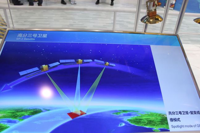
Talking to China Daily, China Academy of Space Technology's Gaofen 3 Project Head Xu Fuxiang explained that the satellite will be instrumental in closely monitoring marine environment as well as islands, reefs, ships and oil rigs that are located within the country's jurisdiction. Gaofen 3’s radar instrument has 12 imaging modes, ranging from wide-area imaging to close-up shots with a best resolution of 1 meter, or approximately 3.3 feet. That will allow the spacecraft to provide clear views of roads, buildings and boats, China’s official Xinhua news agency reported. As Gaofen 3 zooms around Earth, its radar instrument will scan along the satellite’s ground track, measuring microwave beams reflected off the planet’s land and water surfaces to create a map of structures, ships and urban infrastructure.
Gaofen 3 radar imaging satellite launched from Taiyuan by CZ-4C | China Space Report
The press release by CASC highlighted the versatility of Gaofen 3, which can operate in 12 different working modes, from high-resolution (1 m) to large-swatch (650 km), and from maritime imaging to combined land/water imaging. The 2,950 kg mass satellite operate on a 755 km LEO (98º inclination), with a designed operational life of 8 years, the longest among China’s LEO Earth-observation satellites. The radar package is capable of operating for up to an hour, another record in China’s radar satellites.
These images are downloaded through a high-rate data transmission link. Unlike conventional electro-optical imagery satellites, SAR satellites can operate in all-weather, day/night conditions, and can even capture images of underwater and underground targets.
Related/Background:
- Gaofen-3 Synthetic Aperture Radar imaging satellite | Errymath
- China's New Satellite To Provide Clear View Of Seas, Borders
- China launches hi-resolution synthetic aperture radar imaging satellite | The Indian Express
- Radar remote sensing satellite launched by China – Spaceflight Now
No comments:
Post a Comment