 |
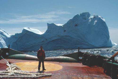
| Mid-sized iceberg astern a vessel on the Grand Banks offshore Newfoundland. (Photo: C-Core) |
Satellite SAR is very effective for surveilling sizeable areas of
the ocean; targets identified in SAR imagery can then be verified by
aerial reconnaissance, minimizing unnecessary but costly deployment of
aircraft. Desmond Power points to the economic benefit of RADARSAT-2,
adding that an oil company engaged C CORE for the first time this year
in order to save money. “Satellite monitoring is a way to save money
compared sending a vessel out there,” he says. “You can surveil up to
250,000 square kilometers for a couple of thousand dollars.”
 |
| Three satellite average daily coverage of Canada (image credit: CSA) |
In the Arctic, Power continues, increased variability within the
seasons is producing anomalous ice environments, which together with
increased maritime activity is making ship detection more complex. The
technology advances that are being developed through Polar Epsilon-2 to
enable increased accuracy in identifying ship and iceberg targets will
assist DND in protecting Canada’s Northern waters.
Developing the capability to discriminate between ships and icebergs
in northern latitudes is a common interest shared by Canada’s Department
of National Defense (DND) and the oil and gas industry. For DND, the
focus is on ship detection for maritime security, whereas oil and gas
companies are interested in detecting icebergs to ensure primarily the
safety and also the productivity of offshore exploration and production
operations.
MDA to deliver a broad-area maritime surveillance system using the RADARSAT Constellation Mission | news.sys-con.com
RICHMOND, BC, June 17, 2016 /CNW/ - MacDonald, Dettwiler and Associates Ltd. ("MDA" or the "Company") (TSX:MDA), a global communications and information company, today announced that
it has signed a CA$48.5 million (including taxes) contract with the Government of Canada to deliver an advanced broad-area global maritime and Arctic surveillance solution, called Polar Epsilon 2 (PE2), to the Department of National Defence (DND). The contract includes two years of in-service support to operate and maintain the delivered systems. The contract also has options which could increase the contract value to CA$63.1 million.
The PE2 ground systems will include ground segment systems with the capability to receive and exploit information from the RADARSAT Constellation Mission (RCM) Synthetic Aperture Radar (SAR) satellites, currently being built by MDA for the Canadian Space Agency. PE2 will provide DND with daily maritime information over millions of square kilometers from SAR imagery, all within minutes of imaging.
Polar Epsilon
The Polar Epsilon and Polar Epsilon-2 applied R&D projects are
focused on improving detection capabilities through the use of synthetic
aperture radar (SAR) via RADARSAT-2 and the RADARSAT Constellation Mission (RCM)—three satellites the Canadian Space Agency is scheduled to
launch in 2018. A partnership between DND and C-CORE of St. John’s,
Newfoundland and Labrador is developing the expertise to use SAR imagery
to differentiate between ships and icebergs. “This case clearly
demonstrates the synergy that exists between the Canadian government and
the oil and gas industry,” notes Desmond Power, vice-president of remote sensing at C-CORE. He explains that a year and a half ago, C-CORE
completed a project in which they developed the capability to provide
ice charts for the oil and gas industry, which invested $1.2 million in
research.
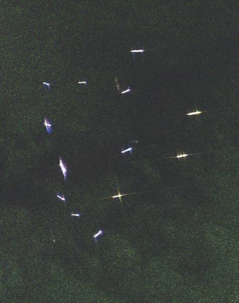 |
| A cluster of vessels near Gibraltar are vividly seen in this fine-resolution quad-polarized radar image; the more features such as antennae on deck, the more pronounced the tell-tale star-shaped signature. (Original image: MDA; processed by C-CORE) |
Now, C-CORE is developing further expertise in this area to
meet DND’s requirements. Power points out that SAR images “are not
pretty Google images. They’re funky-looking echoes instead of nice
shapes.” He adds that microwave radiation is a long wavelength, which
doesn’t reflect back in the same way that the eyes interpret, so it’s
not intuitive. Vessels show up in a diamond pattern. Bright rings in the
image indicate a large supply vessel. “Our people have the experience
to be able to look at images and say ‘That’s an iceberg’,” he says, “and
they’re right 90 to 95 percent of the time.”
Related/Background:
- spendergast: Canadian Maritime Domain Awareness Overview
- Canadian Progress Toward Marine and Coastal Applications of Synthetic Aperture Radar - vachon.pdf
- C-CORE launches project AxES (AIS, EO and Ships) - C-CORE
- Presentation to Arctic Patrol & Reconnaissance 2015 RadarSat Constellation Mission (RCM) - col-dooling.pdf
- RADARSAT-2: CANADA’S LOW KEY SPACE WORKHORSE | Ottawa Citizen
- DND renews contract for ship detection data | Ottawa Citizen
- Jianchao Fan; Jun Wang "Polarimetric SAR image segmentation based on spatially constrained kernel fuzzy C-means clustering", OCEANS 2015 - Genova, On page(s): 1 - 4
- Lang, W.; Zhang, P.; Wu, J.; Shen, Y.; Yang, X. "Incidence Angle Correction of SAR Sea Ice Data Based on Locally Linear Mapping", Geoscience and Remote Sensing, IEEE Transactions on, On page(s): 3188 - 3199 Volume: 54, Issue: 6, June 2016
- Liu, H.; Li, X.; Guo, H. "The Dynamic Processes of Sea Ice on the East Coast of Antarctica—A Case Study Based on Spaceborne Synthetic Aperture Radar Data from TerraSAR-X", Selected Topics in Applied Earth Observations and Remote Sensing, IEEE Journal of, On page(s): 1187 - 1198 Volume: 9, Issue: 3, March 2016
- Liu, H.; Guo, H.; Zhang, L. "SVM-Based Sea Ice Classification Using Textural Features and Concentration From RADARSAT-2 Dual-Pol ScanSAR Data", Selected Topics in Applied Earth Observations and Remote Sensing, IEEE Journal of, On page(s): 1601 - 1613 Volume: 8, Issue: 4, April 2015
- Leigh, S.; Zhijie Wang; Clausi, D.A. "Automated Ice–Water Classification Using Dual Polarization SAR Satellite Imagery", Geoscience and Remote Sensing, IEEE Transactions on, On page(s): 5529 - 5539 Volume: 52, Issue: 9, Sept. 2014
- Karvonen, J. "Baltic Sea Ice Concentration Estimation Based on C-Band Dual-Polarized SAR Data", Geoscience and Remote Sensing, IEEE Transactions on, On page(s): 5558 - 5566 Volume: 52, Issue: 9, Sept. 2014
- Zhu, T.; Li, F.; Heygster, G.; Zhang, S. "Antarctic Sea-Ice Classification Based on Conditional Random Fields From RADARSAT-2 Dual-Polarization Satellite Images", Selected Topics in Applied Earth Observations and Remote Sensing, IEEE Journal of, On page(s): 2451 - 2467 Volume: 9, Issue: 6, June 2016
- Ressel, R.; Frost, A.; Lehner, S. "A Neural Network-Based Classification for Sea Ice Types on X-Band SAR Images", Selected Topics in Applied Earth Observations and Remote Sensing, IEEE Journal of, On page(s): 3672 - 3680 Volume: 8, Issue: 7, July 2015
- Scott, K. Andrea; Ashouri, Zahra; Buehner, Mark; Pogson, Lynn; Carrieres, Tom "Assimilation of SAR data in the marginal ice zone", Radar Conference (RADAR), 2013 IEEE, On page(s): 1 - 5
- Hui Zhang; Wu, Q.M.J.; Thanh Minh Nguyen; Xingming Sun "Synthetic Aperture Radar Image Segmentation by Modified Student's t-Mixture Model", Geoscience and Remote Sensing, IEEE Transactions on, On page(s): 4391 - 4403 Volume: 52, Issue: 7, July 2014
- Pogson, Lynn; Carrieres, Tom; Buehner, Mark; Ross, Michael "SAR data assimilation using characteristic values", Radar Conference (RADAR), 2013 IEEE, On page(s): 1 - 5
- Amelard, R.; Wong, A.; Fan Li; Clausi, D.A. "Unsupervised classification of sea-ice using synthetic aperture radar via an adaptive texture sparsifying transform", Geoscience and Remote Sensing Symposium (IGARSS), 2013 IEEE International, On page(s): 3958 - 3961
- Ashouri, Zahra; Scott, Andrea "A heuristic method to use ice andwater probabilities from SAR imagery to improve ice concentration estimates", Geoscience and Remote Sensing Symposium (IGARSS), 2014 IEEE International, On page(s): 4868 - 4871
- S. Ochilov and D. A. Clausi, "Operational SAR Sea-Ice Image Classification," in IEEE Transactions on Geoscience and Remote Sensing, vol. 50, no. 11, pp. 4397-4408, Nov. 2012.
doi: 10.1109/TGRS.2012.2192278Abstract: Thousands of spaceborne synthetic aperture radar (SAR) sea-ice images are systematically processed every year in support of operational activities such as ship navigation and environmental monitoring. An automated approach that generates pixel-level sea-ice image classification is required since manual pixel-level classification is not feasible. Currently, using a standardized approach, trained ice analysts manually segment full SAR scenes into smaller polygons to record ice types and concentrations. Using these data, pixel-level classification can be achieved by initial unsupervised segmentation of each polygon, followed by automatic sea-ice labeling of the full scene. A fully automated Markov random field model that is used to assign labels to all segmented regions in the full scene has been designed and implemented. This approach is the first known successful end-to-end process for operational SAR sea-ice image classification. In addition, a novel performance evaluation framework has been developed to validate the segmentation and labeling of SAR sea-ice images. A trained sea-ice expert has conducted an arms length evaluation using this framework to generate a set of full-scene reference images used for testing. Testing demonstrates operational success of the labeling approach.
keywords: {geophysical image processing;geophysical techniques;image classification;image segmentation;radar imaging;sea ice;SAR scenes;SAR sea-ice image classification;automated Markov random held model;automatic sea-ice labeling;environmental monitoring;manual pixel-level classihcation;pixel-level sea-ice image classification;polygon initial unsupervised segmentation;ship navigation;spaceborne SAR sea-ice images;synthetic aperture radar;trained ice analysts;Image classification;Image segmentation;Labeling;Markov random fields;Sea ice;Synthetic aperture radar;Image classification;Markov random field (MRF);sea ice;synthetic aperture radar (SAR);unsupervised segmentation},
URL: http://ieeexplore.ieee.org/stamp/stamp.jsp?tp=&arnumber=6197709&isnumber=6339100
No comments:
Post a Comment